UPSC Articles

SCIENCE & TECHNOLOGY/ DISASTER MANAGEMENT/ GEOGRAPHY
Topic: General Studies 1,2,3:
- Science and Technology- developments and their applications and effects in everyday life.
- Disaster and disaster management.
Cyclones forecast
Context: Cyclone Nivar, that barrelled through Tamil Nadu and brought copious rain in its wake, was the third major cyclone to land on India’s coast this year, besides Amphan and Nisarga.
However, relatively fewer lives were lost compared to the havoc wreaked by Amphan in West Bengal in May. What aided relief operations in the anticipation of Nivar was that it largely conformed to forecasts issued by the India Meteorological Department (IMD).
How are cyclones forecast?
- Over the years, India’s ability to track the formation of cyclones has improved significantly.
- Radar Network: There is a network of 21 doppler weather radars (DWR) in the country (12 along the coast). Depending on where a storm is forming, these radars send pulses of radio waves to gauge the size as well as the speed at which water droplets are moving.
- Real time feedback: The earlier generation of radars was unable to track such progress in real time, but with DWRs, now the base standard of weather radars, it is usually possible to detect a potential storm at least four-five days in advance.
- International Collaborations: The IMD also collaborates with similar international networks, such as the Japan Meteorological Agency, the U.S. National Hurricane Center, and the U.S. Central Pacific Hurricane Center, and these bodies constantly send warnings and forecasts about changes in the ocean weather.
- Technologies that supplement radars: The near ubiquity of ocean-buoys that track changes in ocean sea surface temperatures as well as dedicated meteorological satellites improve the odds of early detection
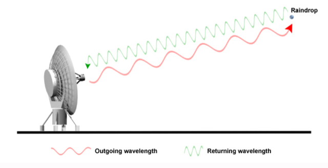
How radar works?
- The basics of radars is that a beam of energy, called radio waves, is emitted from an antenna. As they strike objects in the atmosphere, the energy is scattered in all directions with some of the energy reflected directly back to the radar.
- The larger the object, the greater the amount of energy that is returned to the radar. That provides us with the ability to “see” rain drops in the atmosphere.
- In addition, the time it takes for the beam of energy to be transmitted and returned to the radar also provides us with the distance to that object.
Doppler radar
- By their design, Doppler radar systems can provide information regarding the movement of targets as well as their position.
- When the radar transmits pulses of radio waves, the system keeps track of the phase (shape, position, and form) of those pulses.
- By measuring the shift (or change) in phase between a transmitted pulse and a received echo, the target’s movement directly toward or away from the radar is calculated.
- A positive phase shift implies motion toward the radar and a negative shift indicates motion away from the radar.
- The phase shift effect is similar to the “Doppler shift” observed with sound waves. With the “Doppler shift”, the sound pitch of an object moving toward your location is higher due to compression (a change in the phase) of sound waves. As an object moves away from your location, sound waves are stretched resulting in a lower frequency.
How difficult was it to track Nivar’s progress?
- April-June and October-December are India’s cyclone seasons.
- The arriving monsoon, as well as its retreat, stir up the surrounding seas and generate cyclones.
- Though the Bay of Bengal is three times more likely to generate cyclones, the ones that originate in the Arabian Sea are trickier, as the cyclone, while ostensibly moving away from India’s western coast, can suddenly ‘recurve’ and move back in.
- A challenge with re-curving cyclones is that it is hard for weather models to pick them early on.
- There are also fewer radars along India’s west coast than the eastern coast, and all these reasons make the Bay of Bengal cyclones more tractable.
- In this context, Nivar, because it conformed to a fairly predictable trajectory and was not super cyclonic in intensity, gave State administrations in Puducherry, Tamil Nadu and Andhra Pradesh time to prepare, and was far less damaging than Amphan.
- However, the cyclone season is not yet over and more systems are likely to form in the coming weeks, according to the IMD.
How has disaster warning changed?
- Tracking Depressions: The formation of cyclones is preceded by ‘depressions’, and they are often the first warnings. Not all depressions become cyclones, but many coastal States — especially those with a history of being battered — begin organising shelters and evacuation of coastal residents.
- Suspension of advisories on fish catches: Sea pockets, where cyclones form, are also places that drive schools of fish and lure fisherfolk. While meteorological agencies give advisories on where fish-catches are likely, they suspend such advisories during storm formation to dissuade fishermen from venturing out.
- Penetration of Mobile Phones: The ubiquity of mobile communication makes it much easier to quickly give warnings.
- Collaboration with Urban Local Bodies: The IMD also issues flood forecast maps, in collaboration with urban bodies that forecast which pockets in a city are likely to be flooded and where crop damage is likely to be maximum.
Conclusion
- Forecasts, on their own, are important, but they cannot override the importance of preparedness by State agencies.
Connecting the dots:
- Questions on Disaster Management along with Synopsis: Click Here
For a dedicated peer group, Motivation & Quick updates, Join our official telegram channel – https://t.me/IASbabaOfficialAccount
Subscribe to our YouTube Channel HERE to watch Explainer Videos, Strategy Sessions, Toppers Talks & many more…