IASbaba Prelims 60 Days Plan, Rapid Revision Series (RaRe)

Archives
Hello Friends
The 60 Days Rapid Revision (RaRe) Series is IASbaba’s Flagship Initiative recommended by Toppers and loved by the aspirants’ community every year.
It is the most comprehensive program which will help you complete the syllabus, revise and practice tests on a daily basis. The Programme on a daily basis includes
Daily Prelims MCQs from Static (Monday – Saturday)
- Daily Static Quiz will cover all the topics of static subjects – Polity, History, Geography, Economics, Environment and Science and technology.
- 20 questions will be posted daily and these questions are framed from the topics mentioned in the schedule.
- It will ensure timely and streamlined revision of your static subjects.
Daily Current Affairs MCQs (Monday – Saturday)
- Daily 5 Current Affairs questions, based on sources like ‘The Hindu’, ‘Indian Express’ and ‘PIB’, would be published from Monday to Saturday according to the schedule.
Daily CSAT Quiz (Monday – Friday)
- CSAT has been an Achilles heel for many aspirants.
- Daily 5 CSAT Questions will be published.
Note – Daily Test of 20 static questions, 10 current affairs, and 5 CSAT questions. (35 Prelims Questions) in QUIZ FORMAT will be updated on a daily basis.
To Know More about 60 Days Rapid Revision (RaRe) Series – CLICK HERE
60 Day Rapid Revision (RaRe) Series Schedule – CLICK HERE
Important Note
- Comment your Scores in the Comment Section. This will keep you accountable, responsible and sincere in days to come.
- It will help us come out with the Cut-Off on a Daily Basis.
- Let us know if you enjoyed today’s test 🙂
- You can post your comments in the given format
- (1) Your Score
- (2) Matrix Meter
- (3) New Learning from the Test
Test-summary
0 of 35 questions completed
Questions:
- 1
- 2
- 3
- 4
- 5
- 6
- 7
- 8
- 9
- 10
- 11
- 12
- 13
- 14
- 15
- 16
- 17
- 18
- 19
- 20
- 21
- 22
- 23
- 24
- 25
- 26
- 27
- 28
- 29
- 30
- 31
- 32
- 33
- 34
- 35
Information
The following Test is based on the syllabus of 60 Days Plan-2025 for UPSC IAS Prelims 2025.
To view Solutions, follow these instructions:
- Click on – ‘Start Test’ button
- Solve Questions
- Click on ‘Test Summary’ button
- Click on ‘Finish Test’ button
- Now click on ‘View Questions’ button – here you will see solutions and links.
You have already completed the test before. Hence you can not start it again.
Test is loading...
You must sign in or sign up to start the test.
You have to finish following test, to start this test:
Results
0 of 35 questions answered correctly
Your time:
Time has elapsed
You have scored 0 points out of 0 points, (0)
| Average score |
|
| Your score |
|
Categories
- Not categorized 0%
| Pos. | Name | Entered on | Points | Result |
|---|---|---|---|---|
| Table is loading | ||||
| No data available | ||||
- 1
- 2
- 3
- 4
- 5
- 6
- 7
- 8
- 9
- 10
- 11
- 12
- 13
- 14
- 15
- 16
- 17
- 18
- 19
- 20
- 21
- 22
- 23
- 24
- 25
- 26
- 27
- 28
- 29
- 30
- 31
- 32
- 33
- 34
- 35
- Answered
- Review
-
Question 1 of 35
1. Question
With reference to ocean currents, consider the following statements.
- Surface ocean currents constitute about 10 percent of all the water in the ocean.
- The cold waters of the Arctic Circle move towards warmer water in tropical and equatorial regions.
Which of the following statements given above is/are correct?
Correct
Test explained
Incorrect
Test explained
-
Question 2 of 35
2. Question
Which of the following Pacific Ocean currents originated due to the action of the trade winds from east to west?
Correct
Solution (b)
Explanation:
Statement 1 Statement 2 Statement 3 Statement 4 Incorrect Correct Incorrect Incorrect North equatorial current originates from Revilla Gigedo island west of Mexico and flows towards the Philippines Island covering a distance of about 12,000 km from east-west. It is a warm current. It derives from its water from the Californian current and the Southeast Monsoon drift which flows north along the Mexican coast. South equatorial current originated due to the action of the trade winds from east to west. It is a warm current. It extends for about 13,600km from east to west. It is stronger than the North equatorial current. It is further divided into many branches due to the presence of many islands and uneven surface topography. Kuroshio current (Black Tide) is a warm ocean current flowing in a north-easterly direction up to 30o N latitude and it carries warm water off the Formosa coast. It flows towards the north and meets the Oyashio cold current off the Kuril Islands. It is also called as Japan current. Californian current is flowing towards the south along the west coast of the U.S.A. between 23o N and 48o N latitudes. It is a cold current that exhibits a great amount of up welled water. When it enters the region of Trade winds, it is deflected to the right and joins the equatorial current. Incorrect
Solution (b)
Explanation:
Statement 1 Statement 2 Statement 3 Statement 4 Incorrect Correct Incorrect Incorrect North equatorial current originates from Revilla Gigedo island west of Mexico and flows towards the Philippines Island covering a distance of about 12,000 km from east-west. It is a warm current. It derives from its water from the Californian current and the Southeast Monsoon drift which flows north along the Mexican coast. South equatorial current originated due to the action of the trade winds from east to west. It is a warm current. It extends for about 13,600km from east to west. It is stronger than the North equatorial current. It is further divided into many branches due to the presence of many islands and uneven surface topography. Kuroshio current (Black Tide) is a warm ocean current flowing in a north-easterly direction up to 30o N latitude and it carries warm water off the Formosa coast. It flows towards the north and meets the Oyashio cold current off the Kuril Islands. It is also called as Japan current. Californian current is flowing towards the south along the west coast of the U.S.A. between 23o N and 48o N latitudes. It is a cold current that exhibits a great amount of up welled water. When it enters the region of Trade winds, it is deflected to the right and joins the equatorial current. -
Question 3 of 35
3. Question
The majority of reef-building corals are primarily restricted to:
Correct
Solution (c)
Explanation:
Reefs created by the Coral Polyp along the shallow shores of some tropical areas are known as Coral reefs. Coral polyps and Zooxanthellae have a symbiotic relationship. Zooxanthellae provide food to the polyps hiding in the pores of the reef while polyps provide a surface to zooxanthellae. Polyps also secrete mucus which covers the algae. It protects algae from harmful radiation. The marine life that forms a reef can flourish only under strict conditions of temperature, salinity, and water depth. (Hence option c is correct)
Incorrect
Solution (c)
Explanation:
Reefs created by the Coral Polyp along the shallow shores of some tropical areas are known as Coral reefs. Coral polyps and Zooxanthellae have a symbiotic relationship. Zooxanthellae provide food to the polyps hiding in the pores of the reef while polyps provide a surface to zooxanthellae. Polyps also secrete mucus which covers the algae. It protects algae from harmful radiation. The marine life that forms a reef can flourish only under strict conditions of temperature, salinity, and water depth. (Hence option c is correct)
-
Question 4 of 35
4. Question
Which of the following statements is correct about coral reefs?
- Nearly all of the reef building corals are found within the 21℃isotherm.
- Corals even survive with turbidity in the water.
- Fringing reefs are formed in the areas of high rainfall runoff.
Select the correct answer using the code given below:
Correct
Solution (a)
Explanation:
Statement 1 Statement 2 Statement 3 Correct Incorrect Incorrect Nearly all of the reef building corals are found within the 21oC isotherm. Most reefs occur in warm tropical waters between 30 degrees N and S latitudes. Poleward the water is too cold for corals to survive. Temperature below 18oC causes their death. Corals need sunlight to survive. They cannot live in water deeper than 75m. Also, they can’t survive when turbidity or suspension is there in water. Turbidity affects the clarity of the water as well as it blocks the pores on the surface making it difficult for the polyps to get their food. Coral reefs are remarkably flat on top. The upper surface is positioned at the level of the upper third of the tidal range. They are exposed during the low tide but must be covered at high tide. Fringing reefs are attached to land masses ranging from 0.5 to 1 km in width. The corals grow seaward towards their food supply. Beyond its seaward margin, the ocean water deepens rapidly. They are broken and discontinuous where a river stream is entering the sea. Fringing reefs are formed in the areas of low rainfall runoff. The greatest concentration of living material is usually at the seaward edge where plankton and water of normal salinity are available. Permanent fringing reefs are common in the Hawaiian Islands and in similar areas near the tropics. Incorrect
Solution (a)
Explanation:
Statement 1 Statement 2 Statement 3 Correct Incorrect Incorrect Nearly all of the reef building corals are found within the 21oC isotherm. Most reefs occur in warm tropical waters between 30 degrees N and S latitudes. Poleward the water is too cold for corals to survive. Temperature below 18oC causes their death. Corals need sunlight to survive. They cannot live in water deeper than 75m. Also, they can’t survive when turbidity or suspension is there in water. Turbidity affects the clarity of the water as well as it blocks the pores on the surface making it difficult for the polyps to get their food. Coral reefs are remarkably flat on top. The upper surface is positioned at the level of the upper third of the tidal range. They are exposed during the low tide but must be covered at high tide. Fringing reefs are attached to land masses ranging from 0.5 to 1 km in width. The corals grow seaward towards their food supply. Beyond its seaward margin, the ocean water deepens rapidly. They are broken and discontinuous where a river stream is entering the sea. Fringing reefs are formed in the areas of low rainfall runoff. The greatest concentration of living material is usually at the seaward edge where plankton and water of normal salinity are available. Permanent fringing reefs are common in the Hawaiian Islands and in similar areas near the tropics. -
Question 5 of 35
5. Question
With reference to coral reefs, consider the following statements.
- Great Barrier Reef is a single reef extending along the North East coast of Queensland.
- Kwajajein Atoll in the Marshall Islands is the largest atoll in the world.
Which of the following statements given above is/are correct?
Correct
Solution (b)
Explanation:
Statement 1 Statement 2 Incorrect Correct Barrier Reef is a reef parallel to the coast but separated from it by a deep lagoon or a strait. Great Barrier Reef is the largest construction of corals in the world. It extends along the North East coast of Queensland. It is not a single reef but a conglomeration of thousands of interlinking sediments. The largest atoll in terms of the size of its enclosed lagoon is Kwajalein, which is part of the Ralik Chain of the Marshall Islands in the central Pacific Ocean. Its land area is around 16.4 square km, but it encloses a lagoon that measures 2,174 square km in area. Incorrect
Solution (b)
Explanation:
Statement 1 Statement 2 Incorrect Correct Barrier Reef is a reef parallel to the coast but separated from it by a deep lagoon or a strait. Great Barrier Reef is the largest construction of corals in the world. It extends along the North East coast of Queensland. It is not a single reef but a conglomeration of thousands of interlinking sediments. The largest atoll in terms of the size of its enclosed lagoon is Kwajalein, which is part of the Ralik Chain of the Marshall Islands in the central Pacific Ocean. Its land area is around 16.4 square km, but it encloses a lagoon that measures 2,174 square km in area. -
Question 6 of 35
6. Question
What happens to corals when the water they live in becomes too warm?
Correct
Solution (b)
Explanation:
Warmer water temperatures can result in coral bleaching. When water is too warm, corals will expel the algae (zooxanthellae) living in their tissues causing the coral to turn completely white. This is called coral bleaching. When a coral bleaches, it is not dead. Corals can survive a bleaching event, but they are under more stress and are subject to mortality. When algae are lost, polyps start dying as less food is available to them. As more polyps start dying, the protective mucus released by them gets depleted and exposed to more algae, making them vulnerable to the sun. This triggers a chain reaction that can lead to the death of the entire reef. (Hence option b is correct)
Incorrect
Solution (b)
Explanation:
Warmer water temperatures can result in coral bleaching. When water is too warm, corals will expel the algae (zooxanthellae) living in their tissues causing the coral to turn completely white. This is called coral bleaching. When a coral bleaches, it is not dead. Corals can survive a bleaching event, but they are under more stress and are subject to mortality. When algae are lost, polyps start dying as less food is available to them. As more polyps start dying, the protective mucus released by them gets depleted and exposed to more algae, making them vulnerable to the sun. This triggers a chain reaction that can lead to the death of the entire reef. (Hence option b is correct)
-
Question 7 of 35
7. Question
In which of the following regions of the ocean is ocean acidification most pronounced?
Correct
Solution (b)
Explanation:
When carbon dioxide dissolves in seawater, the water becomes more acidic and the ocean’s pH (a measure of how acidic or basic the ocean is) drops. Carbon dioxide dissolves especially well in cold water. That is why ocean acidification is progressing primarily in the polar regions. Acidification of the Arctic Ocean could result in less availability of aragonite, an important building block for calcareous shells, as early as in the middle of this century. (Hence option b is correct)
Incorrect
Solution (b)
Explanation:
When carbon dioxide dissolves in seawater, the water becomes more acidic and the ocean’s pH (a measure of how acidic or basic the ocean is) drops. Carbon dioxide dissolves especially well in cold water. That is why ocean acidification is progressing primarily in the polar regions. Acidification of the Arctic Ocean could result in less availability of aragonite, an important building block for calcareous shells, as early as in the middle of this century. (Hence option b is correct)
-
Question 8 of 35
8. Question
Which of the following factors influenced Climate of India?
- Distance from the Sea
- Distribution of Land and Water
- Physiography of India
- The Himalayan Mountains
Select the correct answer using the code given below:
Correct
Solution (d)
Explanation:
Statement 1 Statement 2 Statement 3 Statement 4 Correct Correct Correct Correct With a long coastline, large coastal areas have an equable climate. Areas in the interior of India are far away from the moderating influence of the sea. Such areas have extremes of climate. That is why, the people of Mumbai and the Konkan coast have hardly any idea of extremes of temperature and the seasonal rhythm of weather. On the other hand, the seasonal contrasts in weather at places in the interior of the country such as Delhi, Kanpur and Amritsar affect the entire sphere of life. India is flanked by the Indian Ocean on three sides in the south and girdled by a high and continuous mountain-wall in the north. As compared to the landmass, water heats up or cools down slowly. This differential heating of land and sea creates different air pressure zones in different seasons in and around the Indian subcontinent. Difference in air pressure causes reversal in the direction of monsoon winds. The physiography or relief of India also affects the temperature, air pressure, direction and speed of wind and the amount and distribution of rainfall. The windward sides of Western Ghats and Assam receive high rainfall during June-September whereas the southern plateau remains dry due to its leeward situation along the Western Ghats. The lofty Himalayas in the north along with its extensions act as an effective climatic divide. The towering mountain chain provides an invincible shield to protect the subcontinent from the cold northern winds. These cold and chilly winds originate near the Arctic circle and blow across central and eastern Asia. The Himalayas also trap the monsoon winds, forcing them to shed their moisture within the subcontinent. Incorrect
Solution (d)
Explanation:
Statement 1 Statement 2 Statement 3 Statement 4 Correct Correct Correct Correct With a long coastline, large coastal areas have an equable climate. Areas in the interior of India are far away from the moderating influence of the sea. Such areas have extremes of climate. That is why, the people of Mumbai and the Konkan coast have hardly any idea of extremes of temperature and the seasonal rhythm of weather. On the other hand, the seasonal contrasts in weather at places in the interior of the country such as Delhi, Kanpur and Amritsar affect the entire sphere of life. India is flanked by the Indian Ocean on three sides in the south and girdled by a high and continuous mountain-wall in the north. As compared to the landmass, water heats up or cools down slowly. This differential heating of land and sea creates different air pressure zones in different seasons in and around the Indian subcontinent. Difference in air pressure causes reversal in the direction of monsoon winds. The physiography or relief of India also affects the temperature, air pressure, direction and speed of wind and the amount and distribution of rainfall. The windward sides of Western Ghats and Assam receive high rainfall during June-September whereas the southern plateau remains dry due to its leeward situation along the Western Ghats. The lofty Himalayas in the north along with its extensions act as an effective climatic divide. The towering mountain chain provides an invincible shield to protect the subcontinent from the cold northern winds. These cold and chilly winds originate near the Arctic circle and blow across central and eastern Asia. The Himalayas also trap the monsoon winds, forcing them to shed their moisture within the subcontinent. -
Question 9 of 35
9. Question
What is the primary reason for the difference in climate between northern and southern India?
Correct
Solution (d)
Explanation:
The Tropic of Cancer passes through the central part of India in east-west direction. Thus, northern part of the India lies in sub-tropical and temperate zone and the part lying south of the Tropic of Cancer falls in the tropical zone. The tropical zone being nearer to the equator, experiences high temperatures throughout the year with small daily and annual range. Area north of the Tropic of Cancer being away from the equator, experiences extreme climate with high daily and annual range of temperature. (Hence option d is correct)
Incorrect
Solution (d)
Explanation:
The Tropic of Cancer passes through the central part of India in east-west direction. Thus, northern part of the India lies in sub-tropical and temperate zone and the part lying south of the Tropic of Cancer falls in the tropical zone. The tropical zone being nearer to the equator, experiences high temperatures throughout the year with small daily and annual range. Area north of the Tropic of Cancer being away from the equator, experiences extreme climate with high daily and annual range of temperature. (Hence option d is correct)
-
Question 10 of 35
10. Question
How does the Coriolis Force influence the direction of the southwest monsoon in India?
Correct
Solution (a)
Explanation:
The Inter Tropical Convergence Zone (ITCZ) is a low pressure zone located at the equator where trade winds converge, and so, it is a zone where air tends to ascend. In July, the ITCZ is located around 20°°N-25°°N latitudes (over the Gangetic plain), sometimes called the monsoon trough. This monsoon trough encourages the development of thermal low over north and northwest India. Due to the shift of ITCZ, the trade winds of the southern hemisphere cross the equator between 40°° and 60°°E longitudes and start blowing from southwest to northeast due to the Coriolis force. It becomes southwest monsoon. In winter, the ITCZ moves southward, and so the reversal of winds from northeast to south and southwest, takes place. They are called northeast monsoons. (Hence option a is correct)
Incorrect
Solution (a)
Explanation:
The Inter Tropical Convergence Zone (ITCZ) is a low pressure zone located at the equator where trade winds converge, and so, it is a zone where air tends to ascend. In July, the ITCZ is located around 20°°N-25°°N latitudes (over the Gangetic plain), sometimes called the monsoon trough. This monsoon trough encourages the development of thermal low over north and northwest India. Due to the shift of ITCZ, the trade winds of the southern hemisphere cross the equator between 40°° and 60°°E longitudes and start blowing from southwest to northeast due to the Coriolis force. It becomes southwest monsoon. In winter, the ITCZ moves southward, and so the reversal of winds from northeast to south and southwest, takes place. They are called northeast monsoons. (Hence option a is correct)
-
Question 11 of 35
11. Question
With reference to the climates of the world, consider the following statements.
- Tropical monsoon climate is found over the Indian sub-continent and North Eastern part of South America only.
- Warm Temperate climate is characterised by hot, dry summer and mild, rainy winter.
- In the Marine West Coast Climate, the temperature is moderate and in winter, it is warmer than its latitude.
- Polar climates exist poleward beyond 60° latitude.
How many of the above statements are correct?
Correct
Solution (c)
Explanation:
Statement 1 Statement 2 Statement 3 Statement 4 Correct Incorrect Correct Correct Tropical monsoon climate (Am) is found over the Indian sub-continent, the North Eastern part of South America, and Northern Australia. Heavy rainfall occurs mostly in summer. Winter is dry. Warm temperate (mid-latitude) climates extend from 30° – 50° of latitude mainly on the eastern and western margins of continents. These climates generally have warm summers with mild winters. In the Marine West Coast Climate, due to marine influence, the temperature is moderate and in winter, it is warmer than for its latitude. The mean temperature in summer months ranges from 15°-20°C and in winter 4°-10°C. The annual and daily ranges of temperature are small. Polar climates exist poleward beyond 70° latitude. Polar climates consist of two types: (i) Tundra (ET); (ii) Ice Cap (EF). The tundra climate (ET) is so called after the types of vegetation, like low growing mosses, lichens and flowering plants. Incorrect
Solution (c)
Explanation:
Statement 1 Statement 2 Statement 3 Statement 4 Correct Incorrect Correct Correct Tropical monsoon climate (Am) is found over the Indian sub-continent, the North Eastern part of South America, and Northern Australia. Heavy rainfall occurs mostly in summer. Winter is dry. Warm temperate (mid-latitude) climates extend from 30° – 50° of latitude mainly on the eastern and western margins of continents. These climates generally have warm summers with mild winters. In the Marine West Coast Climate, due to marine influence, the temperature is moderate and in winter, it is warmer than for its latitude. The mean temperature in summer months ranges from 15°-20°C and in winter 4°-10°C. The annual and daily ranges of temperature are small. Polar climates exist poleward beyond 70° latitude. Polar climates consist of two types: (i) Tundra (ET); (ii) Ice Cap (EF). The tundra climate (ET) is so called after the types of vegetation, like low growing mosses, lichens and flowering plants. -
Question 12 of 35
12. Question
With reference to tropical humid climates, consider the following statements.
- In tropical humid climates, the Annual range of temperature and rainfall is low.
- Tropical wet and dry climates are found to the north and south of the Amazon forest in Brazil.
- Tropical evergreen forests with dense canopy cover are found in tropical monsoon climates.
How many of the above statements are correct?
Correct
Solution (b)
Explanation:
Statement 1 Statement 2 Statement 3 Correct Incorrect Correct Tropical humid climates exist between the Tropic of Cancer and the Tropic of Capricorn. The annual range of temperature is very low and annual rainfall is high. Tropical Wet and Dry Climate is found to the north and south of the Amazon forest in Brazil and adjoining parts of Bolivia and Paraguay in South America, Sudan, and south of Central Africa. Tropical wet and dry climate occurs north and south of tropical wet climate type climate regions. Tropical evergreen forests with dense canopy cover and large biodiversity are found in tropical wet climates. A significant amount of rainfall occurs in every month of the year. The warm and wet climate of tropical regions hosts the most biodiversity and tends to have ideal environmental conditions for plant growth. Incorrect
Solution (b)
Explanation:
Statement 1 Statement 2 Statement 3 Correct Incorrect Correct Tropical humid climates exist between the Tropic of Cancer and the Tropic of Capricorn. The annual range of temperature is very low and annual rainfall is high. Tropical Wet and Dry Climate is found to the north and south of the Amazon forest in Brazil and adjoining parts of Bolivia and Paraguay in South America, Sudan, and south of Central Africa. Tropical wet and dry climate occurs north and south of tropical wet climate type climate regions. Tropical evergreen forests with dense canopy cover and large biodiversity are found in tropical wet climates. A significant amount of rainfall occurs in every month of the year. The warm and wet climate of tropical regions hosts the most biodiversity and tends to have ideal environmental conditions for plant growth. -
Question 13 of 35
13. Question
Which of the following factors does not contribute to the excessive cold in northern India during the winter season?
Correct
Solution (d)
Explanation:
There are three main reasons for the excessive cold in north India during this season : (i) States like Punjab, Haryana and Rajasthan being far away from the moderating influence of sea experience continental climate. (ii) The snowfall in the nearby Himalayan ranges creates cold wave situation; and (iii) Around February, the cold winds coming from the Caspian Sea and Turkmenistanbring cold wave along with frost and fog over the northwestern parts of India. (Hence option 1,2 and 3 are correct)
The monsoon winds are a seasonal phenomenon that occurs during the summer months, not the winter. (Hence option d is incorrect)
Incorrect
Solution (d)
Explanation:
There are three main reasons for the excessive cold in north India during this season : (i) States like Punjab, Haryana and Rajasthan being far away from the moderating influence of sea experience continental climate. (ii) The snowfall in the nearby Himalayan ranges creates cold wave situation; and (iii) Around February, the cold winds coming from the Caspian Sea and Turkmenistanbring cold wave along with frost and fog over the northwestern parts of India. (Hence option 1,2 and 3 are correct)
The monsoon winds are a seasonal phenomenon that occurs during the summer months, not the winter. (Hence option d is incorrect)
-
Question 14 of 35
14. Question
Why do winter monsoons generally not cause rainfall in most parts of India?
Correct
Solution (c)
Explanation:
Winter monsoons do not cause rainfall as they move from land to the sea. It is because firstly, they have little humidity; and secondly, due to anti cyclonic circulation on land, the possibility of rainfall from them reduces. So, most parts of India do not have rainfall in the winter season. (Hence option c is correct).
Incorrect
Solution (c)
Explanation:
Winter monsoons do not cause rainfall as they move from land to the sea. It is because firstly, they have little humidity; and secondly, due to anti cyclonic circulation on land, the possibility of rainfall from them reduces. So, most parts of India do not have rainfall in the winter season. (Hence option c is correct).
-
Question 15 of 35
15. Question
With respect to rainfall in winter season, consider the following statements.
- The average winter rainfall in Delhi is around 53 mm caused by weak temperate cyclones from the Mediterranean sea.
- During October and November, northeast monsoon causes torrential rainfall over the Tamil Nadu coast.
Which of the following statements given above is/are correct?
Correct
Solution (c)
Explanation:
Statement 1 Statement 2 Correct Correct In northwestern India, some weak temperate cyclones from the Mediterranean sea cause rainfall in Punjab, Haryana, Delhi and western Uttar Pradesh. Although the amount is meagre, it is highly beneficial for rabi crops. The precipitation is in the form of snowfall in the lower Himalayas. It is this snow that sustains the flow of water in the Himalayan rivers during the summer months. The precipitation goes on decreasing from west to east in the plains and from north to south in the mountains. The average winter rainfall in Delhi is around 53 mm. During October and November, northeast monsoon while crossing over the Bay of Bengal, picks up moisture and causes torrential rainfall over the Tamil Nadu coast, southern Andhra Pradesh, southeast Karnataka and southeast Kerala. Incorrect
Solution (c)
Explanation:
Statement 1 Statement 2 Correct Correct In northwestern India, some weak temperate cyclones from the Mediterranean sea cause rainfall in Punjab, Haryana, Delhi and western Uttar Pradesh. Although the amount is meagre, it is highly beneficial for rabi crops. The precipitation is in the form of snowfall in the lower Himalayas. It is this snow that sustains the flow of water in the Himalayan rivers during the summer months. The precipitation goes on decreasing from west to east in the plains and from north to south in the mountains. The average winter rainfall in Delhi is around 53 mm. During October and November, northeast monsoon while crossing over the Bay of Bengal, picks up moisture and causes torrential rainfall over the Tamil Nadu coast, southern Andhra Pradesh, southeast Karnataka and southeast Kerala. -
Question 16 of 35
16. Question
What is the primary impact of Nor Westers on the agricultural sector of Bengal?
Correct
Solution (b)
Explanation:
Nor Westers are dreaded evening thunderstorms in Bengal and Assam. Their notorious nature can be understood from the local nomenclature of ‘Kalbaisakhi’, a calamity of the month of Baisakh. These showers are useful for tea, jute and rice cultivation. In Assam, these storms are known as “Bardoisila”. (Hence option b is correct)
Incorrect
Solution (b)
Explanation:
Nor Westers are dreaded evening thunderstorms in Bengal and Assam. Their notorious nature can be understood from the local nomenclature of ‘Kalbaisakhi’, a calamity of the month of Baisakh. These showers are useful for tea, jute and rice cultivation. In Assam, these storms are known as “Bardoisila”. (Hence option b is correct)
-
Question 17 of 35
17. Question
Which of the following statements are correct about tropical marine climate?
- A tropical marine climate is experienced by coastal areas 10° to 20° north or south of the equator.
- The trade winds blow all year round and are moist.
- It is prone to severe tropical cyclones and hurricanes.
Select the correct answer using the code given below:
Correct
Solution (d)
Explanation:
A tropical marine climate is usually experienced by islands and coastal areas 10° to 20° north or south of the equator. They receive rainfall all the time because of trade winds. (Hence statement 1 is correct)
In tropical marine climate the trade winds blow all year round and are moist, as they have passed over warm seas. Due to the steady influence of the trades, the tropical marine climate is more favourable for habitation, but it is prone to severe tropical cyclones and hurricanes. (Hence statement 2 and 3 are correct)
Incorrect
Solution (d)
Explanation:
A tropical marine climate is usually experienced by islands and coastal areas 10° to 20° north or south of the equator. They receive rainfall all the time because of trade winds. (Hence statement 1 is correct)
In tropical marine climate the trade winds blow all year round and are moist, as they have passed over warm seas. Due to the steady influence of the trades, the tropical marine climate is more favourable for habitation, but it is prone to severe tropical cyclones and hurricanes. (Hence statement 2 and 3 are correct)
-
Question 18 of 35
18. Question
What is the name of the cold current that is temporarily replaced by the warm El Niño current?
Correct
Solution (c)
Explanation:
EI-Nino is a complex weather system that appears once every three to seven years, bringing drought, floods and other weather extremes to different parts of the world. The system involves oceanic and atmospheric phenomena with the appearance of warm currents off the coast of Peru in the Eastern Pacific and affects weather in many places including India. EI-Nino is merely an extension of the warm equatorial current which gets replaced temporarily by cold Peruvian current or Humbolt current (locate these currents in your atlas). This current increases the temperature of water on the Peruvian coast by 10°°C. (Hence option c is correct)
Incorrect
Solution (c)
Explanation:
EI-Nino is a complex weather system that appears once every three to seven years, bringing drought, floods and other weather extremes to different parts of the world. The system involves oceanic and atmospheric phenomena with the appearance of warm currents off the coast of Peru in the Eastern Pacific and affects weather in many places including India. EI-Nino is merely an extension of the warm equatorial current which gets replaced temporarily by cold Peruvian current or Humbolt current (locate these currents in your atlas). This current increases the temperature of water on the Peruvian coast by 10°°C. (Hence option c is correct)
-
Question 19 of 35
19. Question
With reference to cold weather season of India, consider the following statements.
- The weather in this season is characterised by feeble high-pressure conditions over the southern plain.
- Winds start blowing from northwestern high-pressure zone to the low air pressure zone over the Indian Ocean.
- The weather conditions get disturbed by shallow cyclonic depressions originating over the east Mediterranean Sea.
How many of the above statements are correct?
Correct
Solution (b)
Explanation:
Statement 1 Statement 2 Statement 3 Incorrect Correct Correct By the end of December (22nd December), the sun shines vertically over the Tropic of Capricorn in the southern hemisphere. The weather in this season is characterised by feeble high pressure conditions over the northern plain. In south India, the air pressure is slightly lower. The isobars of 1019 mb and 1013 mb pass through northwest India and far south, respectively. The isobars of 1019 mb and 1013 mb pass through northwest India and far south, respectively. As a result, winds start blowing from northwestern high pressure zone to the low air pressure zone over the Indian Ocean in the south. During the winters, the weather in India is pleasant. The pleasant weather conditions, however, at intervals, get disturbed by shallow cyclonic depressions originating over the east Mediterranean Sea and travelling eastwards across West Asia, Iran, Afghanistan and Pakistan before they reach the northwestern parts of India. On their way, the moisture content gets augmented from the Caspian Sea in the north and the Persian Gulf in the south. Incorrect
Solution (b)
Explanation:
Statement 1 Statement 2 Statement 3 Incorrect Correct Correct By the end of December (22nd December), the sun shines vertically over the Tropic of Capricorn in the southern hemisphere. The weather in this season is characterised by feeble high pressure conditions over the northern plain. In south India, the air pressure is slightly lower. The isobars of 1019 mb and 1013 mb pass through northwest India and far south, respectively. The isobars of 1019 mb and 1013 mb pass through northwest India and far south, respectively. As a result, winds start blowing from northwestern high pressure zone to the low air pressure zone over the Indian Ocean in the south. During the winters, the weather in India is pleasant. The pleasant weather conditions, however, at intervals, get disturbed by shallow cyclonic depressions originating over the east Mediterranean Sea and travelling eastwards across West Asia, Iran, Afghanistan and Pakistan before they reach the northwestern parts of India. On their way, the moisture content gets augmented from the Caspian Sea in the north and the Persian Gulf in the south. -
Question 20 of 35
20. Question
Which of the following statement is correct about hot weather season of India?
- The temperatures in the hills of Western Ghats remain below 25°°C even during hot weather season.
- Because of the heating, the ITCZ moves northwards occupying a position centred at 25°°N in July.
Select the correct answer using the code given below:
Correct
Solution (c)
Explanation:
Statement 1 Statement 2 Correct Correct The hot weather season in south India is mild and not so intense as found in north India. The Peninsular situation of south India with moderating effect of the oceans keeps the temperatures lower than that prevailing in north India. So, temperatures remain between 26°°C and 32°°C. Due to altitude, the temperatures in the hills of Western Ghats remain below 25°°C. The summer months are a period of excessive heat and falling air pressure in the northern half of the country. Because of the heating of the subcontinent, the ITCZ moves northwards occupying a position centred at 25°°N in July. Roughly, this elongated low pressure monsoon trough extends over the Thar desert in the north-west to Patna and Chotanagpur plateau in the east-southeast. Incorrect
Solution (c)
Explanation:
Statement 1 Statement 2 Correct Correct The hot weather season in south India is mild and not so intense as found in north India. The Peninsular situation of south India with moderating effect of the oceans keeps the temperatures lower than that prevailing in north India. So, temperatures remain between 26°°C and 32°°C. Due to altitude, the temperatures in the hills of Western Ghats remain below 25°°C. The summer months are a period of excessive heat and falling air pressure in the northern half of the country. Because of the heating of the subcontinent, the ITCZ moves northwards occupying a position centred at 25°°N in July. Roughly, this elongated low pressure monsoon trough extends over the Thar desert in the north-west to Patna and Chotanagpur plateau in the east-southeast. -
Question 21 of 35
21. Question
The ‘Great Red Spot’ recently seen in news is related to which of the following planets?
Correct
Solution (b)
Context:
- New observations of the Great Red Spot on Jupiter have revealed that the planet’s atmosphere above and around the infamous storm is surprisingly interesting and active. In this context, UPSC can ask a question about the spot.
Explanation:
- Great Red Spot is an anticyclone, a long-lasting area of high pressure on Jupiter creating a persistent storm. Located in Jupiter’s Southern Hemisphere, it appears as a giant red spot on Jupiter’s surface. The source of the red coloration is unknown. It extends well above Jupiter’s main cloud layers. It is the largest known storm in the Solar System. With a diameter of 15,400 miles, it is almost twice the size of the entire Earth and one-sixth the diameter of Jupiter itself. Hence, option b is the correct answer.
Incorrect
Solution (b)
Context:
- New observations of the Great Red Spot on Jupiter have revealed that the planet’s atmosphere above and around the infamous storm is surprisingly interesting and active. In this context, UPSC can ask a question about the spot.
Explanation:
- Great Red Spot is an anticyclone, a long-lasting area of high pressure on Jupiter creating a persistent storm. Located in Jupiter’s Southern Hemisphere, it appears as a giant red spot on Jupiter’s surface. The source of the red coloration is unknown. It extends well above Jupiter’s main cloud layers. It is the largest known storm in the Solar System. With a diameter of 15,400 miles, it is almost twice the size of the entire Earth and one-sixth the diameter of Jupiter itself. Hence, option b is the correct answer.
-
Question 22 of 35
22. Question
Abel Prize, seen in news recently is associated with?
Correct
Solution (c)
Context:
- The prestigious Abel Prize for mathematics was recently awarded to Japanese mathematician Masaki Kashiwara, a specialist in algebraic analysis, representation theory, and sheaf theory. In this context, a question can be asked by UPSC about the Abel Prize.
Explanation:
- The Abel Prize recognises pioneering scientific achievements in mathematics. It is named after Norwegian mathematician Niels Henrik Abel (1802-29), who in his short life made pioneering contributions to multiple fields. The prize was established by the Norwegian Parliament in 2002, on Abel’s 200th anniversary. First awarded in 2003, the Abel Prize is often considered to be an equivalent of the Nobel Prize, which does not have a category for mathematics. Hence, option c is the correct answer.
Incorrect
Solution (c)
Context:
- The prestigious Abel Prize for mathematics was recently awarded to Japanese mathematician Masaki Kashiwara, a specialist in algebraic analysis, representation theory, and sheaf theory. In this context, a question can be asked by UPSC about the Abel Prize.
Explanation:
- The Abel Prize recognises pioneering scientific achievements in mathematics. It is named after Norwegian mathematician Niels Henrik Abel (1802-29), who in his short life made pioneering contributions to multiple fields. The prize was established by the Norwegian Parliament in 2002, on Abel’s 200th anniversary. First awarded in 2003, the Abel Prize is often considered to be an equivalent of the Nobel Prize, which does not have a category for mathematics. Hence, option c is the correct answer.
-
Question 23 of 35
23. Question
Consider the following statements about Comptroller and Auditor General (CAG) of India:
- The CAG of India is appointed by the President of India through a warrant under his hand and seal.
- He holds office for six years or until reaching the age of 65, whichever comes first.
- He audits the expenditure from the Consolidated Fund of India and state funds.
- He can be removed by the President in the same manner as a Supreme Court judge.
How many of the above statements are correct?
Correct
Solution (d)
Context:
- The Comptroller and Auditor General (CAG) report on ‘Prevention and Mitigation of Vehicular Air Pollution in Delhi’ highlights serious concerns regarding Air Quality Monitoring, Vehicular Pollution, and Government Accountability. In this context, a question can be asked by UPSC about CAG.
Explanation:
- The CAG of India is the head of the Indian Audit and Accounts Department (IA-AD) and is responsible for auditing government expenditures to ensure financial accountability. As per Article 148 of the Indian Constitution, the CAG safeguards the public purse and monitors financial transactions at the central and state levels. He is appointed by the President of India through a warrant under his hand and seal. He holds office for six years or until reaching the age of 65, whichever comes first. Hence, statements 1 and 2 are correct.
- The CAG is one of the key pillars of Indian democracy, alongside the Supreme Court, Election Commission, and Union Public Service Commission (UPSC). He audits the expenditure from the Consolidated Fund of India and state funds. He can be removed by the President in the same manner as a Supreme Court judge, which requires a special majority resolution in both Houses of Parliament. Hence, statements 3 and 4 are correct.
Incorrect
Solution (d)
Context:
- The Comptroller and Auditor General (CAG) report on ‘Prevention and Mitigation of Vehicular Air Pollution in Delhi’ highlights serious concerns regarding Air Quality Monitoring, Vehicular Pollution, and Government Accountability. In this context, a question can be asked by UPSC about CAG.
Explanation:
- The CAG of India is the head of the Indian Audit and Accounts Department (IA-AD) and is responsible for auditing government expenditures to ensure financial accountability. As per Article 148 of the Indian Constitution, the CAG safeguards the public purse and monitors financial transactions at the central and state levels. He is appointed by the President of India through a warrant under his hand and seal. He holds office for six years or until reaching the age of 65, whichever comes first. Hence, statements 1 and 2 are correct.
- The CAG is one of the key pillars of Indian democracy, alongside the Supreme Court, Election Commission, and Union Public Service Commission (UPSC). He audits the expenditure from the Consolidated Fund of India and state funds. He can be removed by the President in the same manner as a Supreme Court judge, which requires a special majority resolution in both Houses of Parliament. Hence, statements 3 and 4 are correct.
-
Question 24 of 35
24. Question
Test question
Correct
Test explained
Incorrect
Test explained
-
Question 25 of 35
25. Question
Consider the following statements about Indian Naval Sailing Vessel (INSV) Tarini:
- INSV Tarini is an indigenously built sailing vessel built under Make in India Initiative.
- The vessel is named after the Tara-Tarini hill shrine in Odisha, which was historically revered by sailors for safe voyages.
- It is equipped with a Raymarine navigation suite, satellite communication systems, and emergency steering mechanisms to operate under extreme conditions.
Which of the above statements is/are correct?
Correct
Solution (d)
Context:
- The Indian Naval Sailing Vessel (INSV) Tarini has reached Cape Town, South Africa, marking the fourth and final international stop in its global circumnavigation expedition, Navika Sagar Parikrama II. So, UPSC can ask a question about the vessel.
Explanation:
- INSV Tarini is an indigenously built, 56-foot sailing vessel commissioned into the Indian Navy in February 2017. It was built by Aquarius Shipyard Ltd., Goa, under the Make in India initiative. Hence, statement 1 is correct.
- The vessel is named after the Tara-Tarini hill shrine in Odisha, which was historically revered by sailors for safe voyages. In Sanskrit, ‘Tarini’ means both boat and saviour. It is equipped with a Raymarine navigation suite, satellite communication systems, and emergency steering mechanisms, allowing it to operate under extreme conditions. Hence, statements 2 and 3 are correct.
Incorrect
Solution (d)
Context:
- The Indian Naval Sailing Vessel (INSV) Tarini has reached Cape Town, South Africa, marking the fourth and final international stop in its global circumnavigation expedition, Navika Sagar Parikrama II. So, UPSC can ask a question about the vessel.
Explanation:
- INSV Tarini is an indigenously built, 56-foot sailing vessel commissioned into the Indian Navy in February 2017. It was built by Aquarius Shipyard Ltd., Goa, under the Make in India initiative. Hence, statement 1 is correct.
- The vessel is named after the Tara-Tarini hill shrine in Odisha, which was historically revered by sailors for safe voyages. In Sanskrit, ‘Tarini’ means both boat and saviour. It is equipped with a Raymarine navigation suite, satellite communication systems, and emergency steering mechanisms, allowing it to operate under extreme conditions. Hence, statements 2 and 3 are correct.
-
Question 26 of 35
26. Question
With reference to Chile, consider the following statements:
- Chile is the largest producer of copper globally.
- Chile is regarded as the “Gateway to Antarctica” due to its geographical proximity.
- The country is dominated by the Rockies Mountains, the most extended mountain range in the world.
Which of the above statements is/are correct?
Correct
Solution (b)
Context:
- India and Chile have initiated discussions on a comprehensive trade agreement that aims to enhance economic cooperation. In this context, UPSC can ask a question about Chile and the geographical features present here.
Explanation:
- Located in South America, Chile is a long, narrow country with an average width of 110 miles (~178 km). It is the largest producer of copper globally. Copper is a key component in electronic devices, renewable energy systems, and electric vehicles. It is also a part of the “Lithium Triangle” along with Argentina and Bolivia, a crucial region for battery production. Hence, statement 1 is correct.
- Chile is regarded as the “Gateway to Antarctica” due to its geographical proximity. India and Chile have signed a Letter of Intent to enhance collaboration on Antarctic exploration and research. This aligns with India’s polar research ambitions, complementing its Antarctic and Arctic missions. Hence, statement 2 is correct.
- The country is dominated by the Andes Mountains (the most extended mountain range in the world). The Andes are the highest mountain range outside of Asia. The range’s highest peak, Argentina’s Aconcagua, rises to an elevation of about 6,961 m. Hence, statement 3 is not correct.
Incorrect
Solution (b)
Context:
- India and Chile have initiated discussions on a comprehensive trade agreement that aims to enhance economic cooperation. In this context, UPSC can ask a question about Chile and the geographical features present here.
Explanation:
- Located in South America, Chile is a long, narrow country with an average width of 110 miles (~178 km). It is the largest producer of copper globally. Copper is a key component in electronic devices, renewable energy systems, and electric vehicles. It is also a part of the “Lithium Triangle” along with Argentina and Bolivia, a crucial region for battery production. Hence, statement 1 is correct.
- Chile is regarded as the “Gateway to Antarctica” due to its geographical proximity. India and Chile have signed a Letter of Intent to enhance collaboration on Antarctic exploration and research. This aligns with India’s polar research ambitions, complementing its Antarctic and Arctic missions. Hence, statement 2 is correct.
- The country is dominated by the Andes Mountains (the most extended mountain range in the world). The Andes are the highest mountain range outside of Asia. The range’s highest peak, Argentina’s Aconcagua, rises to an elevation of about 6,961 m. Hence, statement 3 is not correct.
-
Question 27 of 35
27. Question
Consider the following statements about Sangama Dynasty:
- The Sangama Dynasty was the founding dynasty of the Vijayanagara Empire.
- The Sangama Dynasty was founded by Krishnadeva Raya.
Which of the above statements is/are correct?
Correct
Solution (a)
Context:
- A set of rare copper plates dating back to the early 15th century, from the reign of Devaraya I of the Sangama Dynasty, has been unveiled in Bengaluru by Falcon Coins Gallery in collaboration with the Archaeological Survey of India (ASI). In this context, a question about the dynasty can be asked by UPSC.
Explanation:
- The Sangama Dynasty was the founding dynasty of the Vijayanagara Empire, ruling from 1336 to 1485 AD. Established by Harihara I and Bukka Raya I, this dynasty laid the foundation for one of the most powerful empires in South India. The rulers of this dynasty significantly strengthened administration, military power, and territorial expansion, making Vijayanagara a dominant political and cultural centre. Hence, statement 1 is correct and statement 2 is not correct.
Incorrect
Solution (a)
Context:
- A set of rare copper plates dating back to the early 15th century, from the reign of Devaraya I of the Sangama Dynasty, has been unveiled in Bengaluru by Falcon Coins Gallery in collaboration with the Archaeological Survey of India (ASI). In this context, a question about the dynasty can be asked by UPSC.
Explanation:
- The Sangama Dynasty was the founding dynasty of the Vijayanagara Empire, ruling from 1336 to 1485 AD. Established by Harihara I and Bukka Raya I, this dynasty laid the foundation for one of the most powerful empires in South India. The rulers of this dynasty significantly strengthened administration, military power, and territorial expansion, making Vijayanagara a dominant political and cultural centre. Hence, statement 1 is correct and statement 2 is not correct.
-
Question 28 of 35
28. Question
Consider the following statements about North Sentinel Island, seen in news recently:
- It is a part of Lakshadweep islands located in Arabian Sea.
- It harbours one of the world’s last secluded tribes, the Sentinelese.
Which of the above statements is/are correct?
Correct
Solution (b)
Context:
- A U.S. national was recently arrested in the Andaman and Nicobar Islands for allegedly entering the prohibited tribal reserve area of North Sentinel Island. In this context, a question can be asked by UPSC about the island.
Explanation:
- North Sentinel Island is one of the Andaman Islands – an archipelago in the Bay of Bengal – and part of the Indian Union Territory of Andaman and Nicobar Islands. It is located west of the central cluster of the Andaman Islands. The island measures approximately 8 kilometers (5.0 mi) in length and 7 kilometers (4.3 mi) in width, covering an area of about 60 square kilometers (23 sq mi). The island is densely covered in tropical rainforest. Hence, statement 1 is not correct.
- It harbours one of the world’s last secluded tribes — the Sentinelese. They are believed to be direct descendants of the first humans who migrated out of Africa around 60,000 years ago. The tribe has lived in voluntary isolation for thousands of years, fiercely resisting contact with the outside world. Hence, statement 2 is correct.
Incorrect
Solution (b)
Context:
- A U.S. national was recently arrested in the Andaman and Nicobar Islands for allegedly entering the prohibited tribal reserve area of North Sentinel Island. In this context, a question can be asked by UPSC about the island.
Explanation:
- North Sentinel Island is one of the Andaman Islands – an archipelago in the Bay of Bengal – and part of the Indian Union Territory of Andaman and Nicobar Islands. It is located west of the central cluster of the Andaman Islands. The island measures approximately 8 kilometers (5.0 mi) in length and 7 kilometers (4.3 mi) in width, covering an area of about 60 square kilometers (23 sq mi). The island is densely covered in tropical rainforest. Hence, statement 1 is not correct.
- It harbours one of the world’s last secluded tribes — the Sentinelese. They are believed to be direct descendants of the first humans who migrated out of Africa around 60,000 years ago. The tribe has lived in voluntary isolation for thousands of years, fiercely resisting contact with the outside world. Hence, statement 2 is correct.
-
Question 29 of 35
29. Question
Consider the following statements about Katchatheevu Islands, seen in news recently:
- Katchatheevu is an uninhabited island situated in the Palk Strait between India and Sri Lanka.
- It was formed due to a volcanic eruption.
- British India and Sri Lanka both claimed the island until the 1974 agreement settled sovereignty in India’s favour.
Which of the above statements is/are correct?
Correct
Solution (b)
Context:
- The Tamil Nadu Legislative Assembly has once again unanimously adopted a resolution urging the Union government to retrieve Katchatheevu from Sri Lanka. In this context, a question can be asked by UPSC about the island.
Explanation:
- Katchatheevu is a 285-acre uninhabited island situated in the Palk Strait between India and Sri Lanka. It is 33 km northeast of Rameswaram (India) and 62 km southwest of Jaffna (Sri Lanka). It was formed due to a volcanic eruption in the 14th century. Hence, statements 1 and 2 are correct.
- Initially ruled by the Jaffna kingdom (Sri Lanka), later controlled by the Ramnad Zamindari under the Nayak dynasty (Madurai). British India and Sri Lanka both claimed the island until the 1974 agreement settled sovereignty in Sri Lanka’s favour. Hence, statement 3 is not correct.
Incorrect
Solution (b)
Context:
- The Tamil Nadu Legislative Assembly has once again unanimously adopted a resolution urging the Union government to retrieve Katchatheevu from Sri Lanka. In this context, a question can be asked by UPSC about the island.
Explanation:
- Katchatheevu is a 285-acre uninhabited island situated in the Palk Strait between India and Sri Lanka. It is 33 km northeast of Rameswaram (India) and 62 km southwest of Jaffna (Sri Lanka). It was formed due to a volcanic eruption in the 14th century. Hence, statements 1 and 2 are correct.
- Initially ruled by the Jaffna kingdom (Sri Lanka), later controlled by the Ramnad Zamindari under the Nayak dynasty (Madurai). British India and Sri Lanka both claimed the island until the 1974 agreement settled sovereignty in Sri Lanka’s favour. Hence, statement 3 is not correct.
-
Question 30 of 35
30. Question
With reference to Binturong, seen in news recently, which of the following statements is/are correct?
- It is also known as the bearcat.
- It is found only in India and Bhutan.
- It is listed as Endangered in the IUCN Red List.
Select the correct answer using the code given below:
Correct
Solution (a)
Context:
- A rare Binturong was recently captured on a camera trap set up by the Wildlife Trust of India’s Garo Green Spine project team in the Narang Wari Village Reserve Forest (VRF), located in the buffer zone of Balpakram National Park. In this context, a question can be asked by UPSC about Binturong.
Explanation:
- Binturong is a catlike omnivore of the civet family. It is the largest civet in India, colloquially known as the bearcat. It has long, shaggy hair, tufted ears, and a long, bushy, prehensile tail. The colour generally is black with a sprinkling of whitish hairs. It is principally nocturnal and crepuscular (that is, active during twilight). Hence, statement 1 is correct.
- It is found in dense forests of Southeast Asia. Its range extends from Nepal, India, and Bhutan southward to the Indonesian islands of Sumatra and Java and eastward to Borneo. And it is listed as Vulnerable in the IUCN Red List. Hence, statements 2 and 3 are not correct.
Incorrect
Solution (a)
Context:
- A rare Binturong was recently captured on a camera trap set up by the Wildlife Trust of India’s Garo Green Spine project team in the Narang Wari Village Reserve Forest (VRF), located in the buffer zone of Balpakram National Park. In this context, a question can be asked by UPSC about Binturong.
Explanation:
- Binturong is a catlike omnivore of the civet family. It is the largest civet in India, colloquially known as the bearcat. It has long, shaggy hair, tufted ears, and a long, bushy, prehensile tail. The colour generally is black with a sprinkling of whitish hairs. It is principally nocturnal and crepuscular (that is, active during twilight). Hence, statement 1 is correct.
- It is found in dense forests of Southeast Asia. Its range extends from Nepal, India, and Bhutan southward to the Indonesian islands of Sumatra and Java and eastward to Borneo. And it is listed as Vulnerable in the IUCN Red List. Hence, statements 2 and 3 are not correct.
-
Question 31 of 35
31. Question
Passage – 1
Child-rearing involves nurturing and guiding a child through various stages of development. Parents navigate a dynamic journey, adapting to the changing needs and personalities of their children. Understanding and meeting a child’s needs requires a multifaceted approach. Effective communication, setting boundaries, and providing a supportive environment contribute to a child’s emotional well-being. Balancing discipline with love and fostering independence while ensuring safety present intricate challenges. Parents often find joy in the process of imparting values, skills, and knowledge. Providing a secure foundation for a child’s exploration of the world contributes to the fulfilling nature of parenting.
Q.31) Which of the following is/are the most rational and logical inference/inferences that can be made from the passage?
- Only parents can contribute to the emotional well-being of their children.
- A supportive environment and good communication are ingredients of a good child-rearing practice.
Select the correct answer from the code given below:
Correct
Solution (b)
Explanation
Inference 1 is incorrect: Refer to the line: “Parents navigate a dynamic journey …communication, setting boundaries, and providing a supportive environment contribute to a child’s emotional well-being.” This line does underline the role of parents in emotional development of their children. However, it does not mean that others (like friends and teachers) do not contribute to emotional well-being of children. So, this inference is not correct.
Inference 2 is correct: The given inference is correct as it is based on the lines “Effective communication, setting boundaries, and providing a supportive environment contribute to a child’s emotional well-being.”
Incorrect
Solution (b)
Explanation
Inference 1 is incorrect: Refer to the line: “Parents navigate a dynamic journey …communication, setting boundaries, and providing a supportive environment contribute to a child’s emotional well-being.” This line does underline the role of parents in emotional development of their children. However, it does not mean that others (like friends and teachers) do not contribute to emotional well-being of children. So, this inference is not correct.
Inference 2 is correct: The given inference is correct as it is based on the lines “Effective communication, setting boundaries, and providing a supportive environment contribute to a child’s emotional well-being.”
-
Question 32 of 35
32. Question
Which one of the following is best implied by the passage?
Correct
Solution (d)
Explanation
Option (a) is incorrect: This option captures only the positive aspect of child-rearing which is a small part of the passage. Other aspects like the challenges of child-rearing are not captured in this option. Also, the passage does not mention that the end goal is for them to become “responsible and compassionate model citizens.” Therefore, this answer option is incorrect.
Option (b) is incorrect: The passage is about the complexity and good things of child-rearing. Child rearing, as done by parents, includes the transfer of values, skills, and knowledge. However, whether such rearing depends on societal values or not is not covered in the passage. So, this is not the best-implied meaning of the passage.
Option (c) is incorrect: The context of child rearing and success is not covered in the passage. The passage does not link good child rearing with a successful life or vice-a-versa. Hence, this is not the best-implied meaning of the passage.
Option (d) is correct: The given option is based on the lines “Balancing discipline with love and fostering independence while ensuring safety present intricate challenges. Parents often find joy in the process of imparting values, skills, and knowledge.” These lines validate that child rearing is a complex process, but parents do enjoy it.
Incorrect
Solution (d)
Explanation
Option (a) is incorrect: This option captures only the positive aspect of child-rearing which is a small part of the passage. Other aspects like the challenges of child-rearing are not captured in this option. Also, the passage does not mention that the end goal is for them to become “responsible and compassionate model citizens.” Therefore, this answer option is incorrect.
Option (b) is incorrect: The passage is about the complexity and good things of child-rearing. Child rearing, as done by parents, includes the transfer of values, skills, and knowledge. However, whether such rearing depends on societal values or not is not covered in the passage. So, this is not the best-implied meaning of the passage.
Option (c) is incorrect: The context of child rearing and success is not covered in the passage. The passage does not link good child rearing with a successful life or vice-a-versa. Hence, this is not the best-implied meaning of the passage.
Option (d) is correct: The given option is based on the lines “Balancing discipline with love and fostering independence while ensuring safety present intricate challenges. Parents often find joy in the process of imparting values, skills, and knowledge.” These lines validate that child rearing is a complex process, but parents do enjoy it.
-
Question 33 of 35
33. Question
Find the missing letter pair in the following matrix.
LX GT DK IR TV KP XU ? NM Correct
Solution (c)
Explanation
Given matrix:
- Column Row
C1 C2 C3 R1 LX GT DK R2 IR TV KP R3 XU ? NM Let’s consider R1C1,
In the term ‘LX’, the product of the alphabetical position of L (12) and reverse alphabetical position of X (3) = 12 × 3 = 36 = (6)2.
Applying a similar pattern in the whole matrix, we get:
LX 36
GT 49
DK 64
IR 81
TV 100 KP 121 XU 144
? 169 NM 196
R1C2 = GT = alphabetical value of G × reverse alphabetical value of T = 7×7 = 72
R1C3 = DK = alphabetical value of D × reverse alphabetical value of K = 4×16 = 82 R2C1 = IR = alphabetical value of I × reverse alphabetical value of R = 9×9 = 92
R2C2 = TV = alphabetical value of T × reverse alphabetical value of V = 20×5 = 102
R2C3 = KP = alphabetical value of K × reverse alphabetical value of P = 11×11 = 112
R3C1 = XU = alphabetical value of X × reverse alphabetical value of U = 24×6 = 122
R3C2 = 169 = 13×13 = alphabetical position of M × reverse alphabetical position of N = MN R3C3 = NM = alphabetical value of N × reverse alphabetical value of M = 14×14 = 142
Hence, required term is ‘MN’.
So, option (c) is the correct answer.
Incorrect
Solution (c)
Explanation
Given matrix:
- Column Row
C1 C2 C3 R1 LX GT DK R2 IR TV KP R3 XU ? NM Let’s consider R1C1,
In the term ‘LX’, the product of the alphabetical position of L (12) and reverse alphabetical position of X (3) = 12 × 3 = 36 = (6)2.
Applying a similar pattern in the whole matrix, we get:
LX 36
GT 49
DK 64
IR 81
TV 100 KP 121 XU 144
? 169 NM 196
R1C2 = GT = alphabetical value of G × reverse alphabetical value of T = 7×7 = 72
R1C3 = DK = alphabetical value of D × reverse alphabetical value of K = 4×16 = 82 R2C1 = IR = alphabetical value of I × reverse alphabetical value of R = 9×9 = 92
R2C2 = TV = alphabetical value of T × reverse alphabetical value of V = 20×5 = 102
R2C3 = KP = alphabetical value of K × reverse alphabetical value of P = 11×11 = 112
R3C1 = XU = alphabetical value of X × reverse alphabetical value of U = 24×6 = 122
R3C2 = 169 = 13×13 = alphabetical position of M × reverse alphabetical position of N = MN R3C3 = NM = alphabetical value of N × reverse alphabetical value of M = 14×14 = 142
Hence, required term is ‘MN’.
So, option (c) is the correct answer.
-
Question 34 of 35
34. Question
In a row of children, Manoj is tenth from the left and Kamal is thirteenth from the right. Vimal is 20th from the right end and third to the right of Manoj. How many children are there between Manoj and Kamal?
Correct
Solution (a)
Explanation
According to the question,
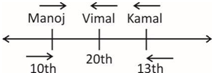
Thus, there are 6 people in between Kamal and Vimal.
Vimal is third to the right of Manoj. So, there are two people in between Manoj and Vimal. Hence, there are a total of (6 + 2 + 1) i.e. 9 persons in between Manoj and Kamal.
Hence, option (a) is the right answer.
Incorrect
Solution (a)
Explanation
According to the question,
Thus, there are 6 people in between Kamal and Vimal.
Vimal is third to the right of Manoj. So, there are two people in between Manoj and Vimal. Hence, there are a total of (6 + 2 + 1) i.e. 9 persons in between Manoj and Kamal.
Hence, option (a) is the right answer.
-
Question 35 of 35
35. Question
Six persons are standing around a circular table facing the center. Balram is between Kamal and Kishan. Manoj is between Sanjay and Vishal. Kamal is on the left of Sanjay. Who is on the left of Kishan?
Correct
Solution (b)
Explanation
As per the given information, we can draw the following sitting arrangement:
Hence, it is clear that Vishal is on the left of Kishan.
So, option (b) is the right answer.
Incorrect
Solution (b)
Explanation
As per the given information, we can draw the following sitting arrangement:
Hence, it is clear that Vishal is on the left of Kishan.
So, option (b) is the right answer.
All the Best
IASbaba


