TLP-UPSC Mains Answer Writing

SYNOPSIS: IASbaba’s TLP – 2018: UPSC Mains General Studies Questions [23rd November 2017]- Day 4
1. Comment on the pattern of ocean surface temperature of the world. What are the factors that affect this pattern? Discuss.
Approach:
This year a question was asked on the salinity profile of Oceans. That was technical but that is how UPSC is. We are getting very technical questions in GS geography. In this question there are two aspects that are to be taken care of –
First how the temperature profile is changing and second what are the factors causing that change.
It’s is a better approach to cover both the things together and with factor we can write the change.
Body
Sea surface temperature (SST) is the water temperature close to the ocean’s surface. The exact meaning of surface varies according to the measurement method used, but it is between 1 millimetre (0.04 in) and 20 metres (70 ft) below the sea surface.
Factors affecting temperature of ocean regions
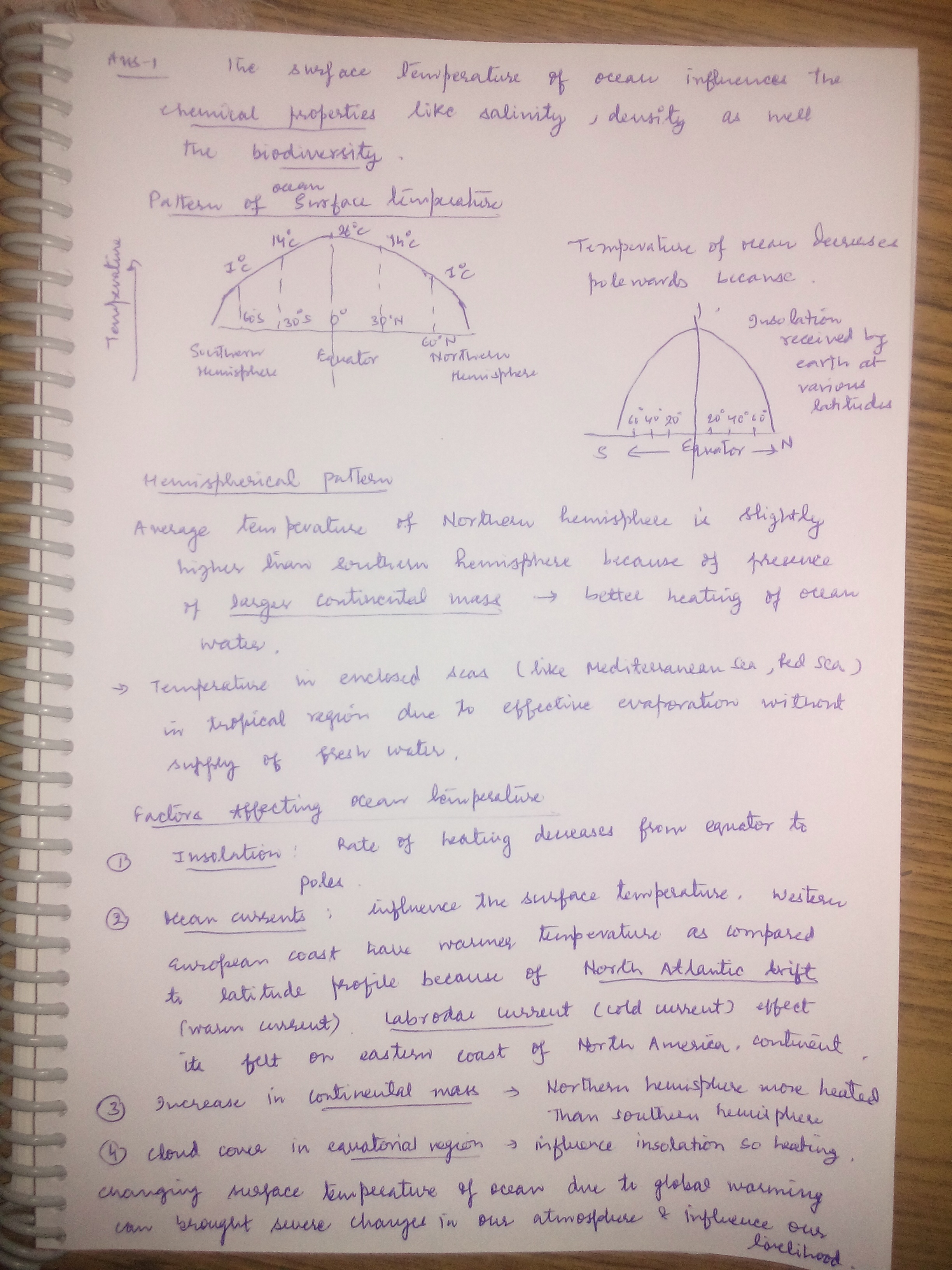
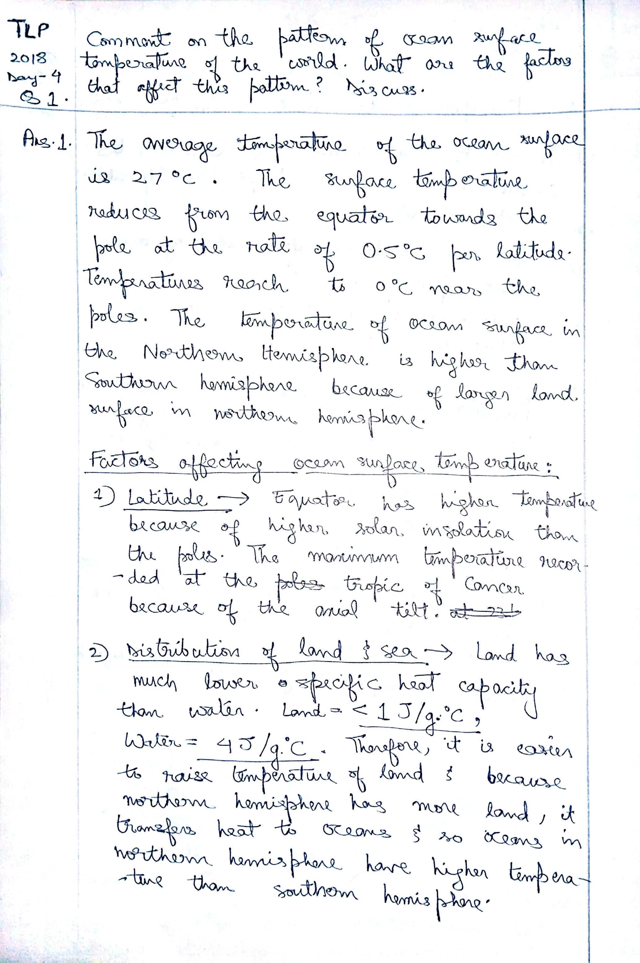
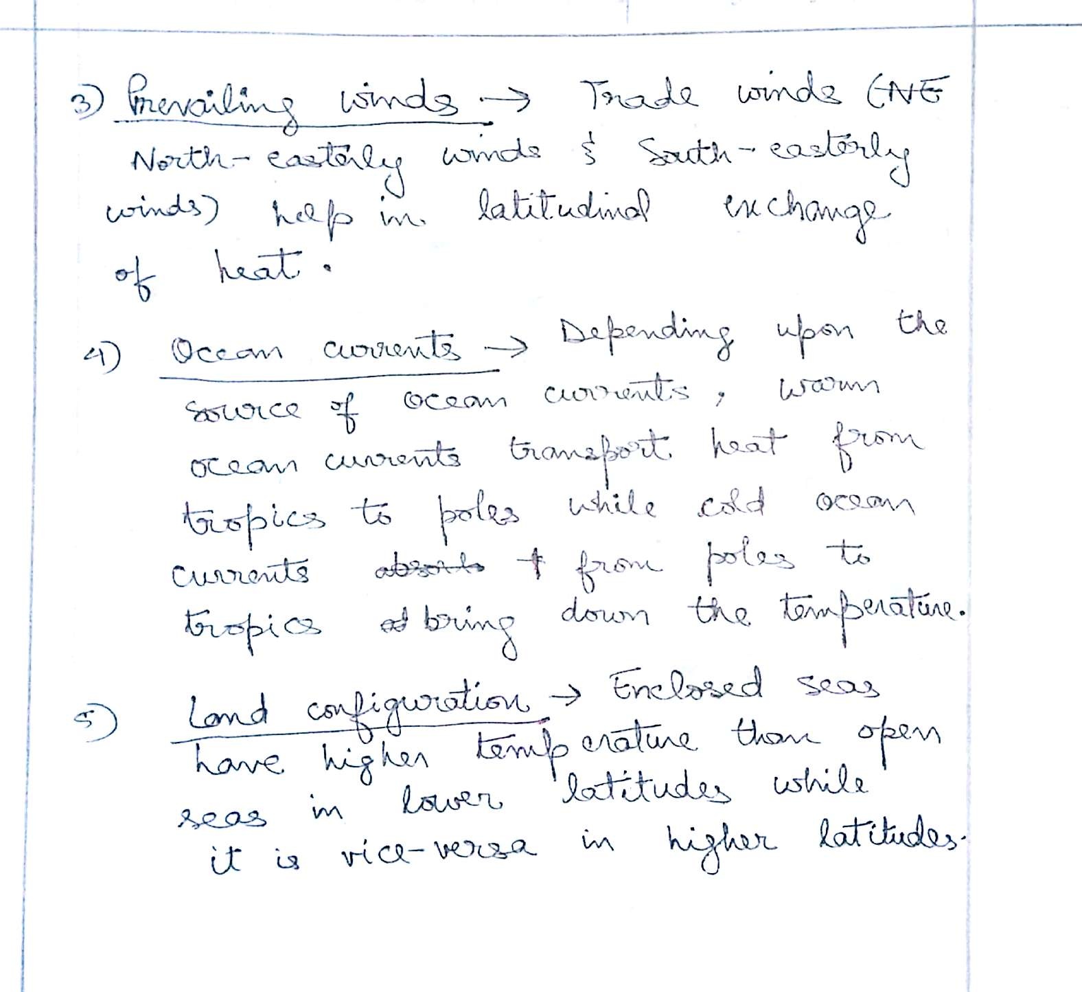
- Insolation and Albedo (proportion of insolation reflected back): Insolation is highest at equator and it decreases as we move towards pole. As sun is the basic source of energy, temperature profile also follows the same pattern.
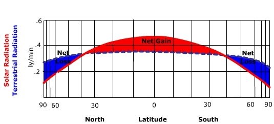
- Cloud cover: Cloud cover hinders the direct insolation. At a given time earth is covered 50% with clouds. As equator is covered with clouds, temperature at tropics is higher than the equator.
- Salinity – increases boiling point of water, thus evaporation decreases. Hence with higher salinity temperature is high.
- Enclosed sea record higher temperature than open sea where inter-mixing of warm and cold water takes place.
- Contact with land: Oceans in the northern hemisphere are warmer than in the southern hemisphere due to greater contact with land surface
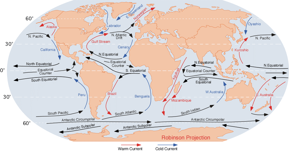
- Ocean Currents: This is a mechanism of temperature distribution in ocean. Where warm currents carry warm water from equator towards the pole and vice versa. Cold currents have cooling effect in an area like Peru Current and Labrador Current. Because of Labrador current during winters in northern hemisphere ports are closed on the western Atlantic down to 40o while because of the presence of hot gulf current ports at Norway cost are open upto 60o.
- Upwelling: On the eastern side of ocean water comes to the surface from the depth of ocean. This water is very cold and have a cooling effect on the surface.
Connecting the dots:
- Vertical temperature profile of ocean
- How does the salinity and density profile water changes in ocean?
Best Answer 1: Poltu
Best Answer 2: Rohan
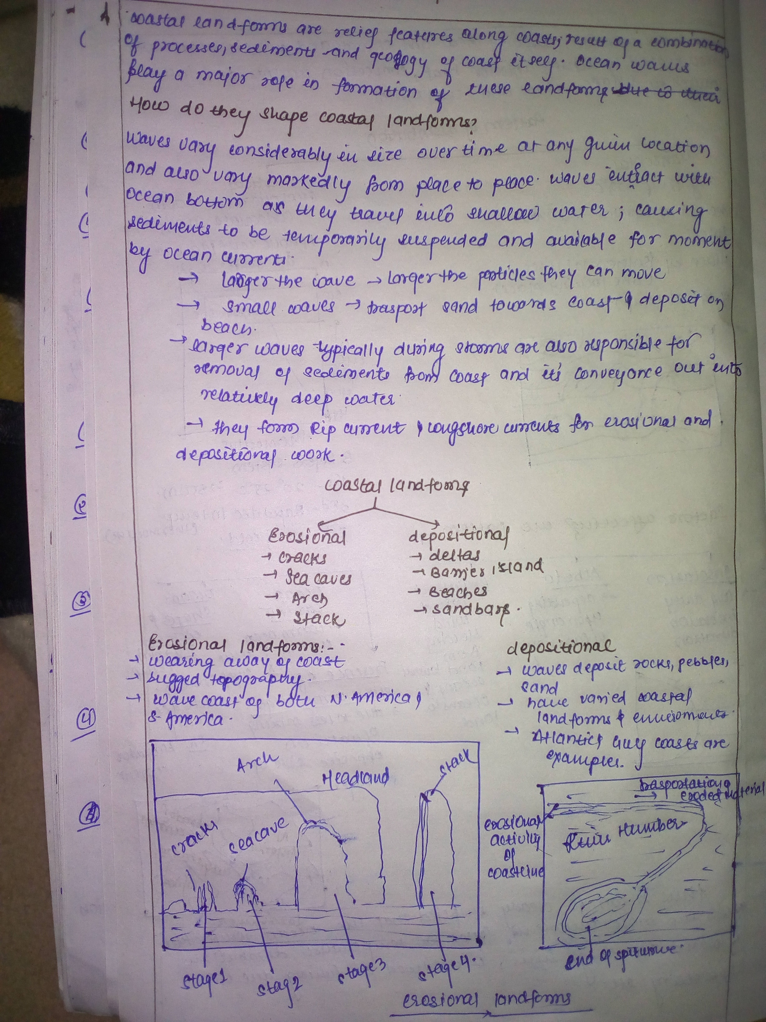
Q.2) How do ocean waves shape the coastal landform? Discuss with the help of suitable examples.
Background:
The landforms that develop and persist along the coast are the result of a combination of processes acting upon the sediments and rocks present in the coastal zone. The most prominent of these processes involves waves and the currents that they generate, along with tides. Other factors that significantly affect coastal morphology are climate and gravity.
Approach:
Introduce with how coastal landforms will form and then focus on how ocean waves will shape the coastal land forms, then explain different types of coastal landforms with suitable examples.
Introduction:
Coastal landforms, any of the relief features present along any coast, the result of a combination of processes, sediments, and the geology of the coast itself. The landforms that develop and persist along the coast are the result of a combination of processes acting upon the sediments and rocks present in the coastal zone. The most prominent of these processes involves waves and the currents that they generate, along with tides. Other factors that significantly affect coastal morphology are climate and gravity.
Landforms of Erosional Coasts:
There are two major types of coastal morphology: one is dominated by erosion and the other by deposition. They exhibit distinctly different landforms, though each type may contain some features of the other.
Erosional coasts typically exhibit high relief and rugged topography. They tend to occur on the leading edge of lithospheric plates, the west coasts of both North and South America being excellent examples.
Sea cliffs: The most widespread landforms of erosional coasts are sea cliffs. These very steep to vertical bedrock cliffs range from only a few metres high to hundreds of metres above sea level. E.g. The coasts of California and Oregon.
Wave-cut platforms: At the base of most cliffs along a rocky coast one finds a flat surface at about the mid-tide elevation. E.g. Shore platform at St Bees Head, UK.
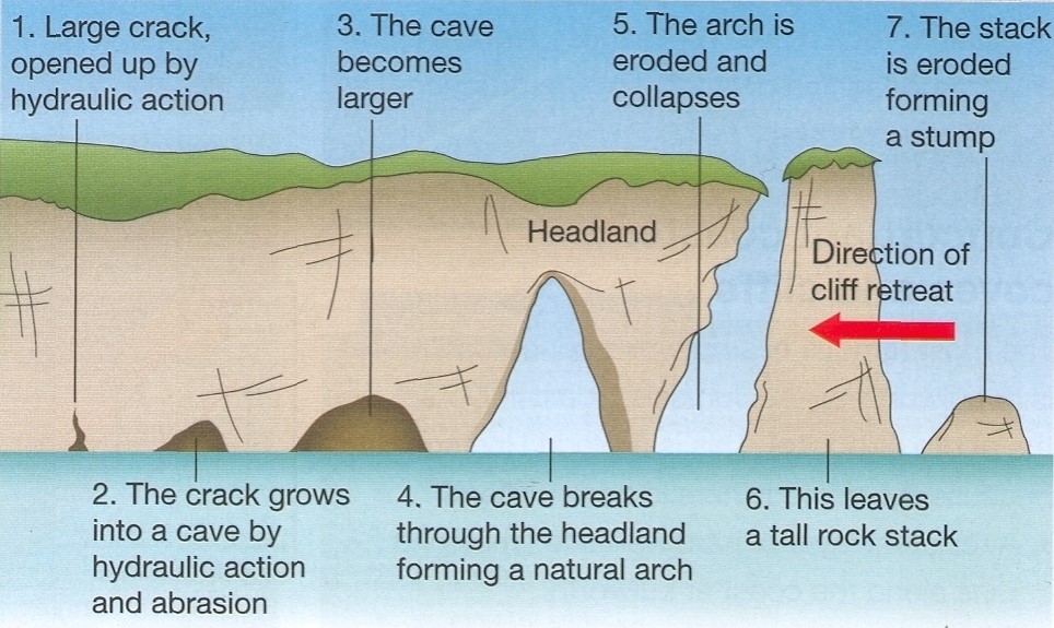
Sea stacks: Erosion along rocky coasts occurs at various rates and is dependent both on the rock type and on the wave energy at a particular site. E.g. Apostles stacks in Victoria, Australia.
Sea arches: Which forms as the result of different rates of erosion typically due to the varied resistance of bedrock. E.g. Kleftiko Beach, on the Greek island of Milos.
Sea cave: It is formed by the forces of the sea, waves seething at the rock face of a coast line, produce sometimes huge caverns, which are typically not very long.
Coastal deposition is the laying down of material on the coast by the sea. It occurs when waves lose energy or when large inputs of sediment are made into the coastal system – perhaps due to the arrival of fluvial sediment at a river estuary.
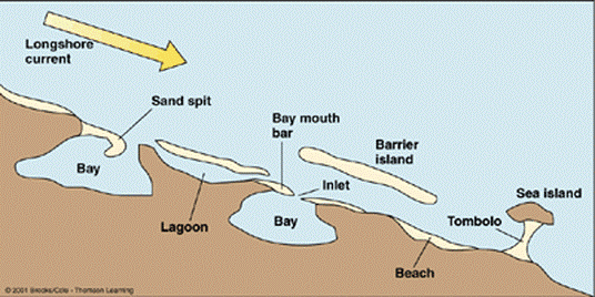
Depositional coasts can be described in terms of the following types:
- Deltas,
- Beaches
- Dunes
- Strand-plain coasts,
- Lagoons, and
- Tombolo
Deltas: An accumulation of sediment at the mouth of a river extending beyond the trend of the adjacent coast is called a delta. E.g. the Mississippi Delta.
Beaches: they are formed from deposits of sediment. E.g. gravel beaches of New England.
Dunes: Immediately landward of the beach are commonly found large, linear accumulations of sand known as dunes. E.g. Thar Desert.
Strand-plain coasts: Some wave-dominated coasts do not contain estuaries and have no barrier island system. These coasts, however, do have beaches and dunes, and may even have coastal marshes. E.g. western Louisiana and eastern Texas.
Lagoons: Sometimes due to deposition of waves and currents, both ends of the bar join to enclose a part of sea water between the coast and the bar E.g. Chilika and Pulicat lakes are examples of Lagoon Lake.
Tombolo: It is a deposition landform in which an island is attached to the mainland by a narrow piece of land such as a spit or bar. E.g. Chesil Beach.
Connecting dots: Question has asked about how ocean waves shape the coastal reforms and it has specifically asked to explain with suitable examples, which most of the students has missed while writing their answer.
Best answer: Disha
Q.3 What are the factors that cause soil erosion. Is it a major issue in India? Discuss. Do you think the ongoing agrarian crisis has been aggravated by the problem of soil erosion? Explain.
Approach:
The answer will have following parts-
- What is soil erosion?
- Factors that cause soil erosion.
- The issue of soil erosion in India- Is it major or minor?
- Relation between ongoing agrarian crisis and soil erosion.
- Diagram- Must in geography answers.
What is soil erosion?
Soil erosion refers to washing away and removal of top layers of soil by agents of denudation like water, wind, glacier etc.
Factors leading to soil erosion are:
- Rainfall: Northern plains soil eroded by frequent flood in the region. Sudden nature of monsoon causes soil erosion. The prolonged dry spell that precedes monsoon causes sheet erosion when monsoon occurs
- Topography: Steep slopes are more prone to erosion.
- Soil Quality: Soil texture, chemical composition and absorbing capacity also decides rate of erosion. Porous soils are least affected by erosion while impervious soil erode gradually by action of water.
- Faulty agricultural practices such as shifting cultivation, indiscriminate use of fertilizers etc
- Other anthropogenic factors like urbanization, over-grazing, deforestation and industrialization.
The issue of soil erosion in India- Is it major or minor?
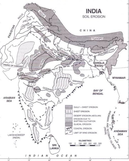
It has been estimated that an area of over 80 million hectares or about one-fourth of our total area is exposed to wind and water erosion out of which 40 million hectares of land has undergone serious erosion.
About 21 million hectares are subject to severe wind erosion in Rajasthan and adjoining areas of Punjab, Haryana, and Gujarat
Pic credit: http://cdn.yourarticlelibrary.com/wp-content/uploads/2013/11/clip_image002107.jpg
Relation between ongoing agrarian crisis and soil erosion:
Though there are various reasons behind ongoing agrarian crisis like high input prices, seed unavailability, lack of fund, market access etc., soil erosion is only aggravating it.
- Loss of important nutrients from the soil ultimately lowers the productivity thereby hurting farmers’ profit.
- Nutrient quality degradation thus more use of fertilizer resulting in increasing expenditure on fertilizers, pesticides, insecticides etc
- Loss of underground water recharge due to soil erosion.
- Widespread ravines in chambal basin.
- Extension of arid land caused by wind erosion aggravated by deforestation, finally culminated into desertification.
Conclusion:
Given the vitality of soil for agriculture, issues like soil erosion and degradation must be handled in effective way. Soil health card, organic farming, forestation enhancement using CAMPA fund, watershed management, contour ploughing, terrace farming, mulching are few progressive steps that should be adopted.
Best answer: mun-mun
Soil erosion is defined as the detachment and movement of topsoil by the action of wind or running water especially as a result of changes brought about by human activity (such as unsuitable or mismanaged agricultural methods). It is leading cause of soil degradation and aggravating the various socio-economic and environmental issues. Following factors lead to it:
- Deforestation: Removal of vegetation cover has caused widespread erosion in Western Ghats, Uttar Pradesh and in Himachal Pradesh.
• Faulty Cultivation Methods: In the Nilgiris, land has been opened for cultivation of tuber crops like potatoes and ginger without undertaking anti-erosive measures like terracing of slopes. Further, hill areas of North-East, Chhotanagpur, etc have suffered erosion of soil because of shifting cultivation.
• Overgrazing: The tread of cattle hardens the soil and prevents new shoots from emerging. Overgrazing by goats is a serious problem in certain stretches of the Aravalis and in Punjab and Himachal hills.
• Wrong irrigation practices: Excessive use of irrigation water in canal command may lead to secondary salinisation, affecting, thereby, the soil and crop productivity.
• Lack of Proper Surface Drainage: Because of proper drainage, waterlogging occurs in low lying areas which loosens the top-soil and makes it prone to erosion.
Magnitude of the Problem in India: India is losing 5,334 million tonnes of soil every year due to soil erosion because of indiscreet and excess use of fertilisers, insecticides and pesticides over the years. In states like Madhya Pradesh, Rajasthan, Maharashtra and Punjab, upto 15 per cent of the total land suffers from soil erosion. Some Glaring Examples of Soil Erosion in India:
- Desertification of Rajasthan: Wind erosion, coupled with loss of surface cover in the Aravallis has made the challenge of halting the march of desert in Rajasthan.
• Coastal Erosion: Sand movement from the coast in the Saurashtra region of Gujarat, where the once flourishing ports are now covered with advancing sand-dunes.
Though reasons are plenty such as lack of fund, market access etc but Soil erosion is aggravating the Indian agriculture crisis in following ways:
• Deposition of Sand and Gravel on Agricultural Lands: The wind-borne sand encroaches the arable lands and makes them unfertile. Crops are damaged due to sand storms.
• Decline in Soil Capacity: When the soil is removed bodily from field the ability of the land to supply moisture for plant growth is reduced and the beneficial activity of micro-organisms lessened. Due to these bad effects, the yields are lowered.
• Degradation through the creation of gullies and ravines, which makes the land inappropriate for agricultural production
Given the importance of soil there is a need for micro-ecological management to stop the degradation before its impacts become catastrophic. Ministry of Agriculture’s various programmes, namely; Soil Health Card Scheme, National Watershed Development Project for Rainfed Areas (NWDPRA), Soil Conservation in the Catchments of River Valley Project and Flood Prone River (RVP&FPR) and Reclamation and Development of Alkali & Acid Soils (RADAS) are steps in the right direction.
4. Why are coastal regions vulnerable? What are the potential threats for coastal regions in India? Do you think a strict regime for coastal regulation is required in India? Examine.
Background: This topic is relevant and will become more relevant in future due to studies on coastal vulnerability and threats to coastal eco system from anthropogenic and natural factors. Globally many big cities are located in coastal regions also resource exploitation becomes important due to increased resource demand.
Approach: First part of question is straightforward and simple. You can start by defining coastal region; write few words about importance of coastal regions, Indian Coast or any other such information.
You need to deal separately with vulnerability and threats part. Write Vulnerability due to climatic and exploitative reasons. Threats should be diverse from natural phenomenon to recent danger of Terror attacks etc
You should draw a diagram for clarity and better presentation. Last part is important requiring examination of strict regime for coastal regulation. You should begin with examining present regulatory mechanisms and highlight their failures. Later on write measures and suggestions and conclude accordingly.
Introduction: Coastal areas are commonly defined as the interface or transition areas between land and sea, including large inland lakes. They are diverse in function and form. The Indian Coastal stretch is made up of diverse ecosystems such as estuaries, lagoons, mangroves, wetlands, beaches and sand dunes.
Body:
Coastal regions are the most vulnerable locations on the earth as they lie in the vicinity of oceans. Slight increase in ocean water levels, events like cyclone, climate change problems have widespread impacts on the all dimensions of life be it economic, social, political.
Coastal regions are vulnerable due to,
Population Density: The average population density in coastal areas is about 80 persons per square kilometer, twice the world’s average population density.
Migration: Migration is a key factor affecting coastal zones. The arrival of new fishermen, with the introduction of new fishing techniques and increased access to credit and markets, contributes to over-exploitation of marine resources.
Urbanization: Many of the world’s major cities are located in coastal areas, and a large portion of economic activities are concentrated in these cities. This has a deleterious effect on mangroves, which absorb the impact of storms and offer nutrients for most of the world’s marine life.
Population’s Interaction with Other Factors: Tourism, fishing, and aquaculture are industries with major economic influences on coastal ecosystems.
In spite of being crucial for development of the nation, export potential through maritime trade, fisheries Coastal regions haven’t been properly regulated till date. For example
- Fragmented decision making, no coordination between coastal states. Various entities such as Marine police force, Coastal Command authorities and Coast guards cause delay in effective action. An effective regulation will streamline the process.
- Encroachment of the wetlands, exploitation of mangroves, sand mining etc would be effectively tackled in case of strict regulations
- Deep sea fishing should be promoted and regulated. Unsustainable fishing practices should be minimized
- Coastal community development should be prioritized.
- Infrastructure development should be disaster resilient.
Conclusion: SagarMala project, Coastal economic zones, Coastal command authority etc are the step in right direction. Early warning system, mitigation and preparation should be streamlined. Coastal regulation is crucial for development of the areas but it should fulfill the aspirations of the local population and should not be too strict.
Connecting the dots: UPSC being in habit of asking multidisciplinary topics from any desired angle. You should be prepared to answer from Economic, Environmental and security related angles. Need to understand from which perspective question is asked and reproduce points accordingly.
Best Answer: Suescribbles
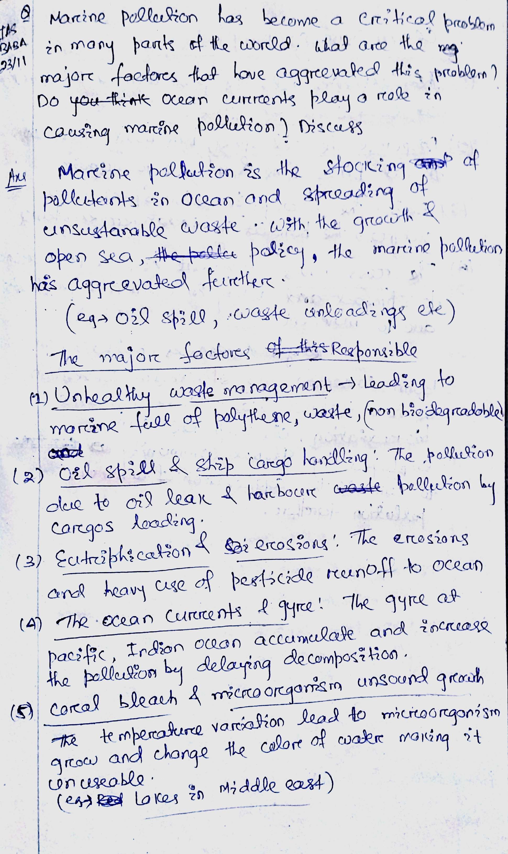
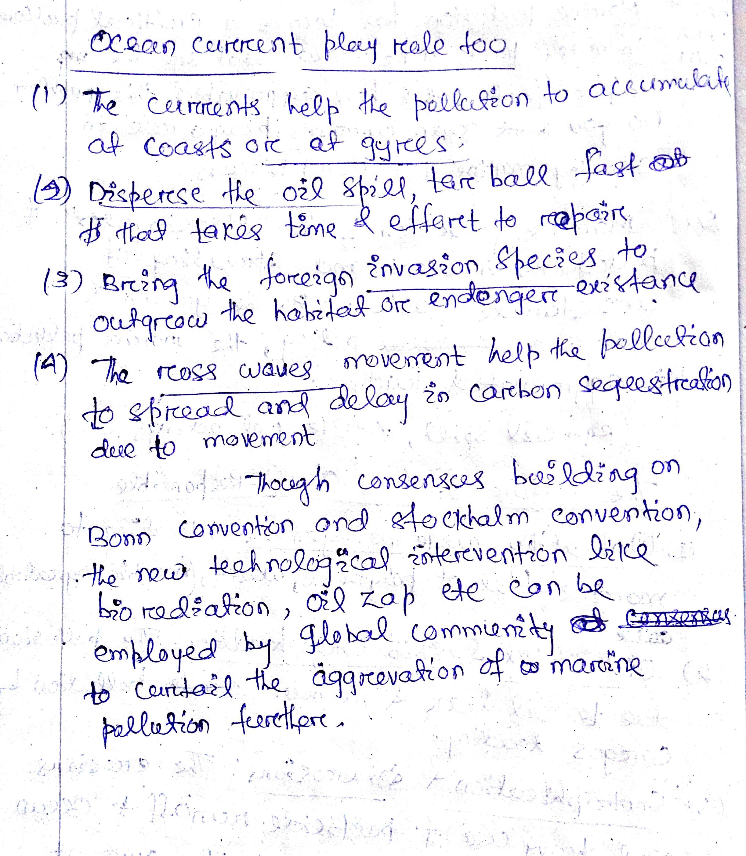
5. Marine pollution has become a critical problem in many parts of the world. What are the major factors that have aggravated this problem? Do ocean currents play a role in causing marine pollution? Discuss.
Approach:
In the introduction mention what do you mean by Marine pollution and a line or two about the problems faced by it. Then in the main part of answer, give around 5-6 points on the factors that leads to marine pollution, here don’t just mention in random order. Categorizing them will fetch you good marks. Then explain how Ocean currents play a role in causing marine pollution.
Background:
Around 70% of our earth consists of water, which plays a vital role in maintaining the ecological and biological cycle of earth. Marine pollution can be explained as a situation where due to continued exploitation by humans, the marine environment is getting degraded causing problems all around the world.
Body:
Points to be covered:
Major factors that have aggravated this problem:
- Unscientific Agricultural Practices: Excess use of chemical fertilizers resulting in polluting run off water and ground water table reaching oceans.
- Industrial wastes: Chemical wastes, Radio-active wastes, Polluted waters.
- Off-shore activities: Mining, Drilling, shipping, oil spillage etc.
- Urbanization: Around coastal cities which has resulted in maximum damage to marine environment
- Defence purposes: Testing weapons, nuclear disasters among others.
Ocean Currents role in causing Marine pollution:
- Transportation: Due to continue circulation, they transport toxic substances from place of origin to destination.
- Breakdown: High energy currents break down the wastes into small fragments, helping in easy transfer and consumption by marine creatures.
- Gyres: Circulations leads to gyres, causing garbage islands. Ex: The Great pacific Garbage island.
- Eutrophication: Nutrient transfer leading to increase in Phytoplankton in water bodies.
Conclusion:
Major cause of pollution is due to human being. Unless stringent measures taken are, there will be nothing left for our future generation. World bodies should come together to find a solution which is effective than the present London convention with provisions for heavy penalties and enforcements.
Connecting the dots:
- Eutrophication, its causes and effects.
- Ocean acidification.
- Plastics problem to marine environment.
Best Answer: lone fighter


