UPSC Articles
INTERNATIONAL/ SECURITY
Topic: General Studies 2,3:
- India and its neighborhood- relations.
- Security challenges and their management in border areas
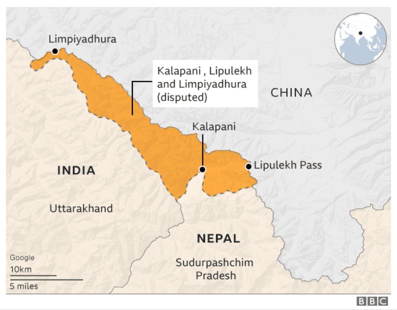
India-Nepal border dispute: Kalapani and Lipulekh
Context: The Nepal government’s decision to pass the constitutional amendment ratifying a change in its maps that include Lipulekh, Kalapani and Limpiyadhura, territories that India controls, marks a decidedly new phase in ties.
Treaty of Sugauli
- The Nepalese kingdom had stretched from the Sutlej river in the west to the Teesta river in the East.
- However, Nepal lost the Anglo-Nepalese War and the resulting Treaty of Sugauli, 1816 limited Nepal to its present territories.
- The Sugauli Treaty stated that Nepal ceded to British the whole of the lowlands between the Rivers Kali and Rapti.
- The Kali River is formed by the union of two headwaters: the Kalapani river that originates below the Lipulekh Pass and the Kuthi Yankit river that rises below the Limpiyadhura range. Both the streams have been termed ‘Kali River’ on different occasions.
- The valley of Kalapani, with the Lipulekh Pass at the top, forms the Indian route to Kailash–Manasarovar.
- The Kali River serves as the boundary between Uttarakhand (Kumaon region) and Nepal from Limpiyadhura.
- In addition to Mahakali/Sharda (West), Gandak/Narayani (South) and Mechi (East) are two other rivers which demarcate the border between India and Nepal.
- By 2007, the Nepal-India Technical Level Joint Boundary Working Group agreed on 182 strip maps covering almost 98% of the boundary, except the two disputed areas of Kalapani and Susta.

Image Source: Karvaan India
Issue of Kalapani area
- Over the decades, these rivers have changed courses several times, giving rise to disputes, claims and counterclaims on land.
- The Nepal government claims that by taking advantage of Nepal’s negligence in guarding its borders, India has encroached on its borderland.
- The former director-general of the Department of Survey of Nepal, claims that maps from 1850 and 1856, prepared by the Survey of India with the participation of Nepali authorities, clearly state that the Mahakal River originates from Limpiyadhura, 16 km northwest of Kalapani, thereby proving that Kalapani belongs to Nepal.
- However, India has consistently refused to accept those maps as proof.
- Indian officials insist that a map drawn up by the British colonial government in 1875 should be considered instead.
- The 1875 map allegedly shows the origin of the Mahakali River to the east of Kalapani. Unlike the maps from 1850 and 1856, the 1875 map does not have Nepal’s certification.
Controversy about Lipulekh pass
- The Lipulekh pass, as well as the Limpayadhura pass (or Limpiya pass), are on Nepal border with Tibet.
- The Lipulekh Pass links Uttarakhand with China’s Tibetan Autonomous Region. The pass is near the tri-junction of India, Nepal and China
- The Lipulekh Pass is situated at an altitude of 5,000 metres. Nepal claims that the Indian army has encroached 372 km2 towards Limpiyadhura from Kalapani since the 1962 Indo-China war. At that time, Nepal, as a friendly neighbour, granted permission to the Indian army to set up a camp in the region.
- Subsequently, despite several firm requests by Nepal’s prime minister at the time, to evacuate the camp, Indian troops stayed put.
- Because of the asymmetric power relationship between the two countries, Nepal has not been able to force India to withdraw its troops from the area
India carried out four escalatory actions in a row –
- First, in May 2015 it signed an agreement with China to use the Lipu Lekh Pass for trade; Kathmandu immediately protested to both New Delhi and Beijing.
- Second, in November 2019 India published a new map that showed Kalapani within its territory.
- Third, India’s defence minister Rajnath Singh inaugurated a road link to Lipu Lekh amid Covid-19 and an ongoing political crisis in Kathmandu.
- Fourth was the statement by Indian Army Chief General M.M. Naravane, implying China had instigated Nepal to lay claims on the area.
Danger of Crisis snowballing into
- At the base of the rift is the lack of diplomatic manoeuvring by India to de-escalate the issue.
- While New Delhi contends that it was willing to discuss matters at a mutually convenient date, Kathmandu says the Ministry of External Affairs (MEA) has rejected two dates suggested by the Nepal
- Nepal also alleges India has routinely dismissed requests from the Nepal Ambassador for a meet with the Foreign Secretary.
- Also, MEA said Kalapani talks could wait until both countries had dealt with the coronavirus pandemic first, which further enraged the Nepali government.
- This was in contrast with India’s participation by videoconference in bilateral and multilateral meetings.
- Meanwhile, Mr. Oli’s (Nepal PM) push towards the amendment at exactly the same time as the India-China border stand-off bolstered the belief that he is speaking with confidence borne from Beijing’s backing.
- The Oli government, which seeks to build its legacy by overturning what it calls “unequal” agreements made by the monarchy, could also cause a security nightmare for India
- If Nepal opens up other parts of their long boundary, and reverses old commitments on open and unsecured border posts, the bilateral relationship will worsen benefitting China.
Conclusion
It is necessary the two nations resolve their issues through dialogue lest they face more serious consequences.
Connecting the dots:
- India-China border flare up
- India-Bangladesh relationship and the peaceful resolution of boundary issues


