IASbaba's Daily Static Quiz
ARCHIVES
DAILY STATIC QUIZ (PYQs)
It will cover PYQs all the topics of static subjects – Polity, History, Geography, Economics, Environment and Science and technology.
Daily 5 questions (Monday to Saturday) will be posted from static topics (PYQs)
The questions will be in the quiz format so you will be able to answer them directly on the portal.
Schedule
- Week 1 – Polity
- Week 2 – Economics
- Week 3 – History and Art & Culture
- Week 4 – Geography
- Week 5 – Environment and Science & Technology
Same cycle will be repeated from Week 6.
Make the best use of the initiative. All the best!
To Know More about Ace the Prelims (ATP) 2021 – CLICK HERE
Important Note:
- Don’t forget to post your marks in the comment section. Also, let us know if you enjoyed today’s test 🙂
- After completing the 5 questions, click on ‘View Questions’ to check your score, time taken and solutions.
Test-summary
0 of 5 questions completed
Questions:
- 1
- 2
- 3
- 4
- 5
Information
To view Solutions, follow these instructions:
- Click on – ‘Start Test’ button
- Solve Questions
- Click on ‘Test Summary’ button
- Click on ‘Finish Test’ button
- Now click on ‘View Questions’ button – here you will see solutions and links.
You have already completed the test before. Hence you can not start it again.
Test is loading...
You must sign in or sign up to start the test.
You have to finish following test, to start this test:
Results
0 of 5 questions answered correctly
Your time:
Time has elapsed
You have scored 0 points out of 0 points, (0)
| Average score |
|
| Your score |
|
Categories
- Not categorized 0%
| Pos. | Name | Entered on | Points | Result |
|---|---|---|---|---|
| Table is loading | ||||
| No data available | ||||
- 1
- 2
- 3
- 4
- 5
- Answered
- Review
-
Question 1 of 5
1. Question
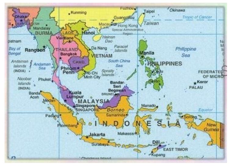
What is the correct sequence of occurrence of the following cities in South-East Asia as one proceeds from south to north? (2014)
- Bangkok
- Hanoi
- Jakarta
- Singapore
Select the correct answer using the code given below:
Correct
Solution (c)
 Incorrect
Solution (c)

-
Question 2 of 5
2. Question
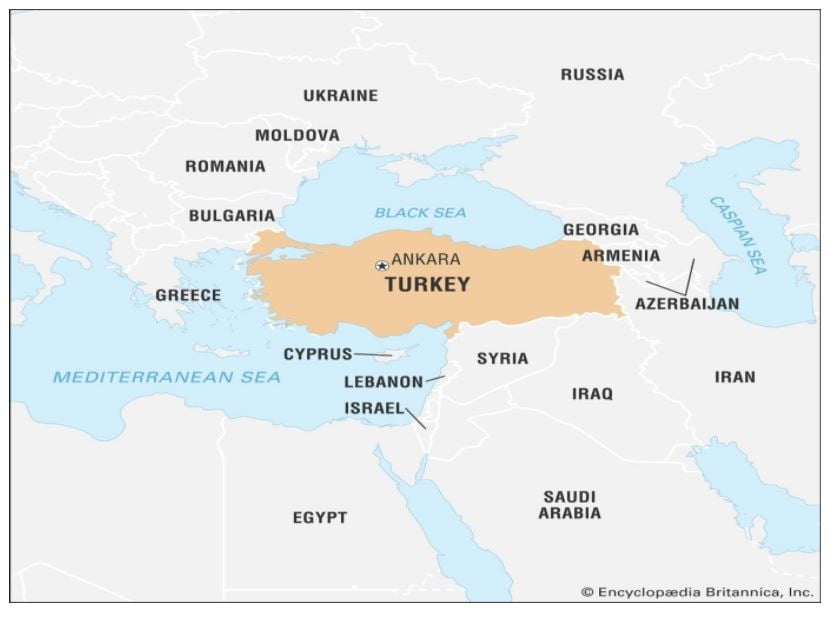
Turkey is located between (2014)
Correct
Solution (b)
 Incorrect
Solution (b)

-
Question 3 of 5
3. Question
Consider the following pairs: (2014)
Hills Region
- Cardamom Hills : Coromandel Coast
- Kaimur Hills : Konkan Coast
- Maadeo Hills : Central India
- Mikir Hills : North-East India
Which of the above pairs are correctly matched?
Correct
Solution (c)
The Cardamom Hills or Yela Mala are mountain range of southern India and part of the southern Western Ghats located in southeast Kerala and southwest Tamil Nadu.
Kaimur Range is the eastern portion of the Vindhya Range, about 483 kilometres long, extending from around Katangi in Jabalpur district of Madhya Pradesh to around Sasaram in Rohtas district of Bihar. It passes through the Rewa and Mirzapur divisions.
The Mahadeo Hills run east and west through Betul, Chhindwara, and Seoni districts, separating the basin of the Narmada River to the north from that of the Wainganga and Wardha rivers, tributaries of the Godavari, to the south. The hills slope gently in the north, but drop steeply to the south onto the Deccan Plateau.
Mikir Hills are a group of hills located to the south of the Kaziranga National Park, Assam.[1] The easternmost Meghalaya comprising the detached Mikir Hills is partly isolated being surrounded by three sides.
Incorrect
Solution (c)
The Cardamom Hills or Yela Mala are mountain range of southern India and part of the southern Western Ghats located in southeast Kerala and southwest Tamil Nadu.
Kaimur Range is the eastern portion of the Vindhya Range, about 483 kilometres long, extending from around Katangi in Jabalpur district of Madhya Pradesh to around Sasaram in Rohtas district of Bihar. It passes through the Rewa and Mirzapur divisions.
The Mahadeo Hills run east and west through Betul, Chhindwara, and Seoni districts, separating the basin of the Narmada River to the north from that of the Wainganga and Wardha rivers, tributaries of the Godavari, to the south. The hills slope gently in the north, but drop steeply to the south onto the Deccan Plateau.
Mikir Hills are a group of hills located to the south of the Kaziranga National Park, Assam.[1] The easternmost Meghalaya comprising the detached Mikir Hills is partly isolated being surrounded by three sides.
-
Question 4 of 5
4. Question
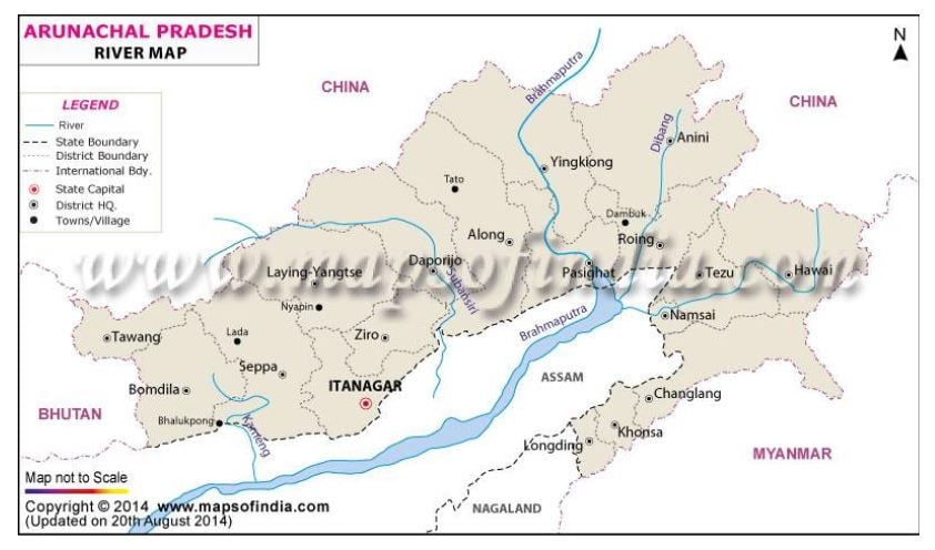
Consider the following rivers: (2014)
- Barak
- Lohit
- Subansiri
Which of the above flows/flow through Arunachal Pradesh?
Correct
Solution (b)
Rivers flowing through Arunachal Pradesh

Barak River flows through Assam, Tripura and Nagaland
Incorrect
Solution (b)
Rivers flowing through Arunachal Pradesh

Barak River flows through Assam, Tripura and Nagaland
-
Question 5 of 5
5. Question
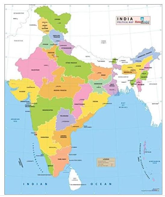
Which one of the following pairs of States of India indicates the easternmost and westernmost State? (2015)
Correct
Solution (d)
 Incorrect
Solution (d)


