IASbaba's Daily Static Quiz
ARCHIVES
DAILY STATIC QUIZ (PYQs)
It will cover PYQs all the topics of static subjects – Polity, History, Geography, Economics, Environment and Science and technology.
Daily 5 questions (Monday to Saturday) will be posted from static topics (PYQs)
The questions will be in the quiz format so you will be able to answer them directly on the portal.
Schedule
- Week 1 – Polity
- Week 2 – Economics
- Week 3 – History and Art & Culture
- Week 4 – Geography
- Week 5 – Environment and Science & Technology
Same cycle will be repeated from Week 6.
Make the best use of the initiative. All the best!
To Know More about Ace the Prelims (ATP) 2021 – CLICK HERE
Important Note:
- Don’t forget to post your marks in the comment section. Also, let us know if you enjoyed today’s test 🙂
- After completing the 5 questions, click on ‘View Questions’ to check your score, time taken and solutions.
Test-summary
0 of 5 questions completed
Questions:
- 1
- 2
- 3
- 4
- 5
Information
To view Solutions, follow these instructions:
- Click on – ‘Start Test’ button
- Solve Questions
- Click on ‘Test Summary’ button
- Click on ‘Finish Test’ button
- Now click on ‘View Questions’ button – here you will see solutions and links.
You have already completed the test before. Hence you can not start it again.
Test is loading...
You must sign in or sign up to start the test.
You have to finish following test, to start this test:
Results
0 of 5 questions answered correctly
Your time:
Time has elapsed
You have scored 0 points out of 0 points, (0)
| Average score |
|
| Your score |
|
Categories
- Not categorized 0%
| Pos. | Name | Entered on | Points | Result |
|---|---|---|---|---|
| Table is loading | ||||
| No data available | ||||
- 1
- 2
- 3
- 4
- 5
- Answered
- Review
-
Question 1 of 5
1. Question
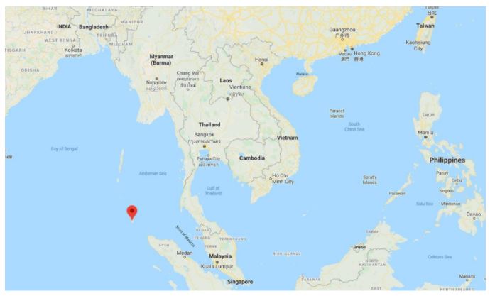
Which of the following is geographically closest to Great Nicobar?
Correct
Solution (a)
Sumatra island is located 180 km to the south of Great Nicobar.
 Incorrect
Solution (a)
Sumatra island is located 180 km to the south of Great Nicobar.

-
Question 2 of 5
2. Question
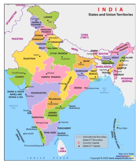
If you travel by road from Kohima to Kottayam, what is the minimum number of States within India through which you can travel, including the origin and the destination?
Correct
Solution (b)
The shortest route from Kohima (Nagaland) to Kottayam (Kerala) passes through the following states: Nagaland-Assam-West BengalOdisha-Andhra Pradesh-Tamil Nadu-Kerala
 Incorrect
Solution (b)
The shortest route from Kohima (Nagaland) to Kottayam (Kerala) passes through the following states: Nagaland-Assam-West BengalOdisha-Andhra Pradesh-Tamil Nadu-Kerala

-
Question 3 of 5
3. Question
From the ecological point of view, which one of the following assumes importance in being a good link between the Eastern Ghats and the Western Ghats?
Correct
Solution (a)
Sathyamangalam forest range is the Gateway to Eastern Ghats, is a significant ecosystem and a wildlife corridor in the Nilgiri Biosphere Reserve between the Western Ghats and the rest of the Eastern Ghats and a genetic link between the five other protected areas which it adjoins, including the Billigiriranga Swamy Temple Wildlife Sanctuary, Sigur Plateau, Mudumalai National Park, Bandipur National Park and the Cauvery Wildlife Sanctuary.
Incorrect
Solution (a)
Sathyamangalam forest range is the Gateway to Eastern Ghats, is a significant ecosystem and a wildlife corridor in the Nilgiri Biosphere Reserve between the Western Ghats and the rest of the Eastern Ghats and a genetic link between the five other protected areas which it adjoins, including the Billigiriranga Swamy Temple Wildlife Sanctuary, Sigur Plateau, Mudumalai National Park, Bandipur National Park and the Cauvery Wildlife Sanctuary.
-
Question 4 of 5
4. Question
At one of the place in India, if you stand on the seashore and watch the sea, ‘you will find that the sea water recedes from the shore line a few kilometres and comes back to the shore, twice a day, and you can actually walk on the sea floor when the water recedes. This unique phenomenon is seen at
Correct
Solution (c)
A unique phenomenon rarely seen anywhere else, the sea recedes by as much as five kilometres every day on the Chandipur beach in eastern India, not just enthralling the onlooker but also offering an opportunity to literally walk into the sea.
Incorrect
Solution (c)
A unique phenomenon rarely seen anywhere else, the sea recedes by as much as five kilometres every day on the Chandipur beach in eastern India, not just enthralling the onlooker but also offering an opportunity to literally walk into the sea.
-
Question 5 of 5
5. Question
What are the benefits of implementing the ‘Integrated Watershed Development Programme?
- Prevention of soil runoff
- Linking the country’s perennial rivers with seasonal rivers
- Rainwater harvesting and recharge of groundwater table
- Regeneration of natural vegetation
Select the correct answer using the code given below:
Correct
Solution (C)
Integrated Watershed Management Programme (IWMP) is implemented by Department of Land Resources of Ministry of Rural Development. The main objective of IWMP is to restore ecological balance by harnessing, conserving and developing degraded natural resources such as soil, vegetative cover and water. Guidelines for IWMP are provided. Get details about Desert Development Programme (DDP). Important documents like format for Annual Action Plan (AAP), format of State Perspective and Strategic Plan (SPSP), etc are also provided. Contact addresses of the divisions are also available.
Integrated watershed development programme nowhere mentions interlinking of rivers
Incorrect
Solution (C)
Integrated Watershed Management Programme (IWMP) is implemented by Department of Land Resources of Ministry of Rural Development. The main objective of IWMP is to restore ecological balance by harnessing, conserving and developing degraded natural resources such as soil, vegetative cover and water. Guidelines for IWMP are provided. Get details about Desert Development Programme (DDP). Important documents like format for Annual Action Plan (AAP), format of State Perspective and Strategic Plan (SPSP), etc are also provided. Contact addresses of the divisions are also available.
Integrated watershed development programme nowhere mentions interlinking of rivers


