IASbaba's Daily Current Affairs Analysis

Archives
(PRELIMS & MAINS Focus)
Syllabus
- Prelims – SCIENCE AND TECHNOLOGY
Context: On May 25, the National Aeronautics and Space Administration (NASA) launched one of the two climate satellites, which would study heat emissions at Earth’s poles. The second satellite will be launched in the following days.
Background:-
- The two shoebox-sized cube satellites, or CubeSats, will measure how much heat the Arctic and Antarctica — two of the coldest regions on the Earth — radiate into space and how this influences the planet’s climate. The mission has been named PREFIRE (Polar Radiant Energy in the Far-InfraRed Experiment) and was jointly developed by NASA and the University of Wisconsin-Madison (US).
what are CubeSats?
- CubeSats are essentially miniature satellites whose basic design is a 10 cm x 10 cm x 10 cm (which makes up for “one unit” or “1U”) cube — just a little bigger than a Rubik’s cube — and weight not more than 1.33 kg. Depending on the CubeSat’s mission, the number of units can be 1.5, 2, 3, 6, and 12U, according to NASA.
- These satellites were first developed in 1999 as educational tools. However, owing to their low cost and less mass in comparison to traditional satellites, they began to be put in orbit for technology demonstrations, scientific research, and commercial purposes.
- Each of the PREFIRE satellites is a 6U CubeSat. They measure around 90 cm in height and nearly 120 cm in width when the solar panels, which will power the satellite, are deployed. The two satellites will be placed in a near-polar orbit (a type of low Earth orbit) at an altitude of about 525 kilometres.
Why do researchers want to measure heat emissions at Earth’s poles?
- It has to do with the Earth’s energy budget, which is the balance between the amount of heat incoming to Earth from the Sun and the amount of heat outgoing from Earth into space. The difference between the two determines the planet’s temperature and climate.
- A large amount of the heat radiated from the Arctic and Antarctica is emitted as far-infrared radiation — wavelengths of 3 μm to 1,000 μm within the infrared range of electromagnetic radiation. However, there is currently no way to measure this type of energy. As a result, there is a gap in knowledge about the planet’s energy budget.
What is the PREFIRE mission?
- The PREFIRE mission will change that. Its two CubeSats can study far-infrared radiation from the Earth’s pole and the data collected by them would help scientists better understand the energy budget of the planet.
- The observations will help understand the fundamentals of Earth’s heat balance, allowing to better predict how our ice, seas, and weather will change in the face of global warming.
- Each of the PREFIRE CubeSat is equipped with a thermal infrared spectrometer — known as Thermal Infrared Spectrometer (TIRS) — to measure the amount of infrared and far-infrared radiation from the Arctic and Antarctica. The spectrometer features specially shaped-mirrors and detectors for splitting and measuring infrared light, according to NASA.
- The CubeSats will also measure the amount of far-infrared radiation trapped by atmospheric water vapour and clouds at the poles and how this influences the greenhouse effect in the region.
Source: Indian Express
Syllabus
- Prelims & Mains – ENVIRONMENT
Context: India’s megacities of Delhi, Mumbai, Chennai, Bengaluru, Kolkata and Hyderabad are experiencing worsening “heat stress” , according to a study by Delhi-based Centre for Science and Environment.
Background:
- The CSE study comes at a time when the country is seeing prolonged heatwaves this summer.Odisha recorded 18 heatwave days, while West Bengal recorded 16 in April. A long heatwave is currently prevailing over Rajasthan and parts of Haryana and Delhi.
Key Takeaways
- Worsening “heat stress” in the six metros under study is due to a trend of rising relative humidity over the past two decades.
- Relative humidity (RH) (expressed as a percent) measures water vapour, but RELATIVE to the temperature of the air.
- In other words, it is a measure of the actual amount of water vapour in the air compared to the total amount of vapour that can exist in the air at its current temperature. Warm air can possess more water vapor (moisture) than cold air.
- Besides rising relative humidity, these cities are also experiencing warmer nights as land surface temperatures are not falling at the same rate as a decade ago, said the analysis, blaming this on the “urban heat island” effect.
- “Urban heat island” effect refers to the trapping of heat due to an increase in built-up area, declining green cover, congestion, heat absorption by urban structures, and heat generated by human activities. This causes the heart of megacities to be much warmer, especially at night, than its outskirts and neighbouring towns.
- Hot nights are as dangerous as mid-day peak temperatures. People get little chance to recover from day-time heat if temperatures remain high overnight.
- The combination of rising air and land surface temperatures and high relative humidity is increasing the heat index and heat stress in these cities. Heat index is a measure of discomfort felt due to high heat and humidity.
- With the exception of Bengaluru, all the other metros have seen a 5-10 per cent rise in average relative humidity during summer, the study noted. According to data, in the last decade, summers in Hyderabad were 10 per cent more humid on an average – the highest among all metros. In Delhi, Mumbai, Kolkata and Chennai, humidity increased by 8 per cent, 7 per cent and 5 per cent, respectively.
- The combination of high heat and humidity can compromise the human body’s main cooling mechanism: sweating. The evaporation of sweat from skin cools our bodies, but higher humidity levels limit this natural cooling, the study said. The combination of these two factors makes people sick and, in some cases, can also prove fatal, even at lower ambient temperatures.
- There is a need to implement emergency measures during heatwaves to protect public health, and also to develop longer term strategies to mitigate heat by increasing green areas and waterbodies, improving thermal comfort in buildings, and reducing waste heat from vehicles, air conditioners and industries.
Source: Indian Express
Syllabus
- Prelims & Mains – Geography & Disaster Management
Context: Cyclone rain-triggered landslides in the Northeast spotlights need for building resilience to multi-hazard disasters.
Background:
- About 13% of India’s area, spread over 15 states and four Union Territories, is prone to landslides.
Key Takeaways
- Cyclone-triggered landslides have hit Northeastern states on earlier occasions as well. Cyclone Aila had caused landslide events in this region in May 2009.
- The latest episode spotlights the need for building resilience to multi-hazard disasters. One event can trigger another, and can lead to multiple disasters simultaneously.
- Over the last few years, India has witnessed events in which heavy rainfall has resulted in a breach of glacial lakes, causing flash floods that have resulted in landslides and flooding.
- Although India has done well to prepare and safeguard itself against certain natural events such as cyclones, landslides remain a weak point.
What are Landslides?
- A landslide is defined as the movement of a mass of rock, debris, or earth down a slope. Landslides are a type of “mass wasting,” which denotes any down-slope movement of soil and rock under the direct influence of gravity. The term “landslide” encompasses five modes of slope movement: falls, topples, slides, spreads, and flows. These are further subdivided by the type of geologic material (bedrock, debris, or earth). Debris flows (commonly referred to as mudflows or mudslides) and rock falls are examples of common landslide types.
- Almost every landslide has multiple causes. Slope movement occurs when forces acting down-slope (mainly due to gravity) exceed the strength of the earth materials that compose the slope. Causes include factors that increase the effects of down-slope forces and factors that contribute to low or reduced strength.
- Landslides can be initiated in slopes already on the verge of movement by rainfall, snowmelt, changes in water level, stream erosion, changes in ground water, earthquakes, volcanic activity, disturbance by human activities, or any combination of these factors. Earthquake shaking and other factors can also induce landslides underwater. These landslides are called submarine landslides. Submarine landslides sometimes cause tsunamis that damage coastal areas.
Landslide vulnerability: India’s Case
- About 0.42 million square km of India’s landmass, or about 13% of its area, spread over 15 states and four Union Territories, is prone to landslides, according to the Geological Survey of India (GSI).
- This covers almost all the hilly regions in the country. About 0.18 million square km, or 42% of this vulnerable area is in the Northeastern region, where the terrain is mostly hilly.This area is also prone to earthquakes, which too, are a major trigger for landslides.
- Government data show that between 2015 and 2022, the eight states in this region, including Sikkim, recorded 378 major landslide events which resulted in loss of life or damage to property. In the country as a whole, Kerala saw the largest number of landslides — 2,239 — most of which occurred after the disastrous 2018 floods in the state.
- The National Disaster Management Authority (NDMA) has been working with GSI and other agencies to mitigate and manage the risks from landslides.
- A National Landslide Risk Management Strategy was finalised in 2019, which talked about vulnerability mapping, identifying the most vulnerable locations, development of an early warning system, and preparation of mountain zone regulations. But most of the work still remains to be done.
Early warning
- Some early warning systems have been developed and deployed on a trial basis at a few locations. These warning systems are linked to rainfall forecasts from IMD. The rainfall prediction is combined with soil and terrain information to calculate whether it is likely to result in displacement of land.
- Most landslides in the hilly regions are caused by heavy rainfall. Earthquakes can trigger landslides too. Since earthquakes themselves cannot be predicted, we cannot have a landslide early warning based on earthquakes. But rainfall-based early warning systems for landslides seem to work well.
- Rainfall forecasts, on the other hand, come quite early. Reliable location-specific predictions are available at least a day in advance. Scientists create a rainfall threshold for land movement and soil displacement at each landslide-prone location. If the rainfall forecast is higher than the threshold, an early warning for landslides is issued.
Human pressure
- The risk from landslides has been exacerbated by the failure to remain mindful of the terrain’s ability to withstand the load. Many hilly areas do not have building regulations. Often, regulations are not implemented effectively.
- New constructions, infrastructure development, and even agricultural practices can increase the risk of landslides.
- Every mountainous area has a carrying capacity. Sustainability has to be factored in, so that the load does not exceed the carrying capacity.
Source: Indian Express
Syllabus
- Prelims & Mains – SCIENCE
Context: Vice President recently visited National Aerospace Limited (NAL) facilities and laid the foundation stone of the Centre for Carbon Fiber and Prepregs in Bengaluru.
Background:
- Carbon fiber can have higher cost than other materials which has been one of the limiting factors of adoption.
Key Takeaways
- Carbon fiber, also known as graphite fiber or carbon graphite, is a material consisting of thin, strong crystalline filaments of carbon. These fibers are about 5 to 10 micrometers in diameter and composed mostly of carbon atoms.
- The properties of carbon fibers include:
- High stiffness
- High tensile strength
- High strength-to-weight ratio
- High chemical resistance
- High-temperature tolerance
- Low thermal expansion
- These properties make carbon fiber popular in various fields such as aerospace, civil engineering, military, motorsports, and other competition sports. However, they are relatively expensive compared to similar fibers, such as glass fibers, basalt fibers, or plastic fibers.
- Carbon fibers are usually combined with other materials to form a composite. For example, when permeated with a plastic resin and baked, it forms carbon-fiber-reinforced polymer which has a very high strength-to-weight ratio and is extremely rigid although somewhat brittle. Carbon fibers are also composited with other materials, such as graphite, to form reinforced carbon-carbon composites, which have a very high heat tolerance.
- Carbon fiber-reinforced materials are used to make aircraft and spacecraft parts, racing car bodies, golf club shafts, bicycle frames, fishing rods, automobile springs, sailboat masts, and many other components where light weight and high strength are needed.
Source: Hindu
Syllabus
- Prelims & Mains – Geography
Context: At least 36 people were killed in heavy rains and landslides in four northeastern states on Tuesday, May 28, under the impact of Cyclone Remal.
Background:
- Tropical cyclones develop in tropical oceans at least 5° – 30° latitude north or south of the equator, where the sea temperature is at least 27 °C. They are important on Earth for transferring heat and energy between the equator and the poles.
About TROPICAL CYCLONES :
- Tropical cyclones are formed in the region between the Tropics of Capricorn and Cancer.
- They’re large-scale weather systems that form over tropical or subtropical oceans and coalesce into surface wind circulation.
- Tropical cyclones are one of the world’s most destructive natural disasters.
Favourable Conditions for the Formation of Tropical Cyclone
- A large area of water surface with a temperature above 27° C
- The Coriolis force is strong enough to form a cyclonic vortex.
- Variations in the vertical wind speed are minor.This allows the storm clouds to rise vertically to high levels.
- A weak low-pressure area or low-level cyclonic circulation already exists.
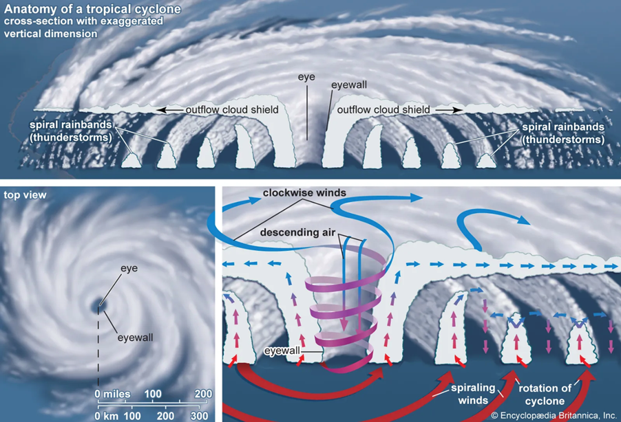
- Above the sea level system, there should be a higher divergence.
Origin of Tropical Cyclones
- Tropical cyclones arise over tropical oceans in late summers and have a thermal origin (August to mid-November).
- Because of the Coriolis effect, the powerful local convectional currents take on a whirling motion at these regions.
Developmental Stages of Tropical Cyclone
Tropical cyclones can be classified into three stages throughout their development:
- Formation and Initial Development Stage
- The transport of water vapor and heat from the warm ocean to the overlying air, largely through evaporation from the sea surface, is crucial to the creation and early development of a cyclonic storm.
- Convection with condensation of rising air above the ocean surface stimulates the creation of huge vertical cumulus clouds.
- Mature Stage
- The air rises in powerful thunderstorms as a tropical storm intensifies, and it tends to spread out horizontally at the tropopause level.
- When air spreads out, a positive pressure is created at high elevations, speeding up the downward migration of air due to convection.
- When subsidence is induced, the air warms up due to compression, resulting in a warm ‘Eye’ (low-pressure center).
- A mature tropical cyclone in the Indian Ocean has a concentric pattern of highly turbulent large cumulus thundercloud bands as its principal physical feature.
- Modification and Decay
- As soon as its source of warm moist air begins to ebb or is abruptly cut off, a tropical cyclone begins to weaken in terms of core low pressure, internal warmth, and extremely fast speeds.
- This occurs after it reaches land or passes across chilly water.
Source: Bureau of Meteorology
Syllabus
- Mains – GS 3
Context: The National Bank for Agriculture and Rural Development (NABARD) unveiled its Climate Strategy 2030 document which aims to address India’s need for green financing.
Background:
- Despite the pressing demand, where India requires approximately US$ 170 billion annually to reach a cumulative total of over US$ 2.5 trillion by 2030, current green finance inflows are critically insufficient.
NABARD’s Climate Strategy 2030:
- It is structured around four key pillars:
- Accelerating Green Lending by focusing on increasing green financing across various sectors.
- Market-making role by playing a broader role in creating a conducive market environment for green finance.
- Internal Green Transformation by implementing sustainable practices within NABARD’s operations.
- Strategic Resource Mobilisation by mobilising resources effectively to support green initiatives.
- This strategy is designed to tackle the financial gap between the required investment for sustainable initiatives and the current inflow of green finance.
- India requires approximately USD 170 billion annually by 2030, aiming for a cumulative total of over USD 2.5 trillion. However, current green finance inflows are critically insufficient, with only about USD 49 billion garnered as of 2019-20.
- The majority of funds in India are earmarked for mitigation efforts, with only USD 5 billion allocated towards adaptation and resilience. This reflects minimal private sector engagement in these areas due to challenges in bankability and commercial viability.
Green Financing:
- Green financing refers to the mobilisation of financial resources to support investments that have a positive environmental impact.
- These investments can range from renewable energy projects and energy efficiency initiatives to sustainable infrastructure development and climate-smart agriculture.
Significance of Green Financing:
- The traditional financial system often prioritises short-term profits over long-term environmental sustainability. Green financing aims to bridge this gap by:
- Facilitating the Transition to a Low-carbon Economy by channelling funds towards renewable energy and clean technologies, green financing helps reduce reliance on fossil fuels and mitigate greenhouse gas emissions.
- Promoting Climate Adaptation and Resilience by making investments in green infrastructure like flood defences and early warning systems can help communities adapt to the changing climate and reduce the impact of natural disasters.
- Unlocking New Economic Opportunities by shifting towards a green economy creates new markets for clean technologies and sustainable practices, stimulating innovation and job creation.
Issues/Challenges Related to Green Financing:
- Green projects often require higher initial investments compared to conventional projects, which can deter investors despite long-term cost savings and environmental benefits.
- Green projects often have longer payback periods and may not align with short-term investment horizons or financial targets of investors and financial institutions.
- The absence of globally accepted standards for green investment leads to ambiguity and inconsistency in evaluating their environmental impact and financial performance. Also, without clear and standardised criteria, there is a risk of greenwashing, where investments are misrepresented as environmentally friendly without delivering substantial sustainability benefits.
Source: NABARD
Practice MCQs
Q1.) Consider the following statements about tropical cyclones
- They are important on Earth for transferring heat and energy between the equator and the poles.
- Tropical cyclones are difficult to form over a region within 5 degrees of latitude from the Equator because the Coriolis force there is too small.
- As soon as itssource of warm moist air begins to ebb or is abruptly cut off, a tropical cyclone begins to weaken.
How many of the statements given above are correct?
- Only one
- Only two
- All three
- None
Q2.) Consider the following statements
- Carbon nanotubes are exponentially more expensive and stronger than carbon fibers.
- Carbon fiber is used in various industries due to its high tensile strength and resistance to corrosion.
- Carbon Nanotubes (CNTs)are cylindrical structures made entirely of carbon atoms arranged in a hexagonal lattice.
How many of the statements given above are correct?
- Only one
- Only two
- All three
- None
Q3.) Consider the following statements regarding Earth’s heat budget:
- The heat budget of Earth is the balance between the energy Earth receives from the Sun and the energy it radiates back into space.
- Albedo refers to the fraction of solar energy reflected back into space by Earth’s surface and atmosphere.
- Greenhouse gases such as carbon dioxide and methane play no role in Earth’s heat budget.
Which of the statements given above is/are correct?
- 1 and 2 only
- 2 and 3 only
- 1 and 3 only
- 1, 2, and 3
Comment the answers to the above questions in the comment section below!!
ANSWERS FOR ’ 29th May 2024 – Daily Practice MCQs’ will be updated along with tomorrow’s Daily Current Affairs.st
ANSWERS FOR 28th May – Daily Practice MCQs
Q.1) – b
Q.2) – b
Q.3) – a