The Current Affairs questions are based on sources like ‘The Hindu’, ‘Indian Express’ and ‘PIB’, which are very important sources for UPSC Prelims Exam. The questions are focused on both the concepts and facts. The topics covered here are generally different from what is being covered under ‘Daily Current Affairs/Daily News Analysis (DNA) and Daily Static Quiz’ to avoid duplication. The questions would be published from Monday to Saturday before 2 PM. One should not spend more than 10 minutes on this initiative.
This is a part of our recently launched, NEW INITIATIVE IASbaba’s INTEGRATED REVISION PLAN (IRP) 2020 – Road Map for the next 100 Days! FREE INITIATIVE!
We will make sure, in the next 4 months not a single day is wasted. All your energies are channelized in the right direction. Trust us! This will make a huge difference in your results this time, provided that you follow this plan sincerely every day without fail.
Gear up and Make the Best Use of this initiative.
Do remember that, “the difference between Ordinary and EXTRA-Ordinary is PRACTICE!!”
Don’t forget to post your marks in the comment section. Also, let us know if you enjoyed today’s test 🙂
After completing the 5 questions, click on ‘View Questions’ to check your score, time taken and solutions.
Time limit: 0
Test-summary
0 of 5 questions completed
Questions:
1
2
3
4
5
Information
To view Solutions, follow these instructions:
Click on – ‘Start Test’ button
Solve Questions
Click on ‘Test Summary’ button
Click on ‘Finish Test’ button
Now click on ‘View Questions’ button – here you will see solutions and links.
You have already completed the test before. Hence you can not start it again.
Test is loading...
You must sign in or sign up to start the test.
You have to finish following test, to start this test:
Results
0 of 5 questions answered correctly
Your time:
Time has elapsed
You have scored 0 points out of 0 points, (0)
Average score
Your score
Categories
Not categorized0%
Your result has been entered into leaderboard
Loading
maximum of 10 points
Pos.
Name
Entered on
Points
Result
Table is loading
No data available
1
2
3
4
5
Answered
Review
Question 1 of 5
1. Question
Consider the following statements with respect to Garima Greh:
The purpose of this scheme is to provide only shelter to transgender person only
It is under Social Justice & Empowerment ministry
Which of the above statements is/are correct?
Correct
Solution (c)
‘Garima Greh: A Shelter Home for Transgender Persons is under Union Minister for Social Justice & Empowerment
Under Garima Greh Scheme of Shelter Home for Transgender Persons, Garima Greh: Shelter Home for Transgender Persons’ has been inaugurated, in Vadodara, Gujarat.
It includes shelter facility, food, clothing, recreational facilities, skill development opportunities, legal support, technical advice for gender transition and surgeries, etc.
The Nodal Ministry has identified 10 cities to set up the 13 Shelter Homes and extend the facilities to Transgender persons, in association with selected 13 Community based organizations (CBOs) in the country on pilot basis.
The cities include Vadodara, New Delhi, Patna, Bhubaneswar, Jaipur, Kolkata, Manipur, Chennai, Raipur and Mumbai.
The scheme will rehabilitate a minimum of 25 transgender persons in each homes identified by the Ministry.
Incorrect
Solution (c)
‘Garima Greh: A Shelter Home for Transgender Persons is under Union Minister for Social Justice & Empowerment
Under Garima Greh Scheme of Shelter Home for Transgender Persons, Garima Greh: Shelter Home for Transgender Persons’ has been inaugurated, in Vadodara, Gujarat.
It includes shelter facility, food, clothing, recreational facilities, skill development opportunities, legal support, technical advice for gender transition and surgeries, etc.
The Nodal Ministry has identified 10 cities to set up the 13 Shelter Homes and extend the facilities to Transgender persons, in association with selected 13 Community based organizations (CBOs) in the country on pilot basis.
The cities include Vadodara, New Delhi, Patna, Bhubaneswar, Jaipur, Kolkata, Manipur, Chennai, Raipur and Mumbai.
The scheme will rehabilitate a minimum of 25 transgender persons in each homes identified by the Ministry.
Question 2 of 5
2. Question
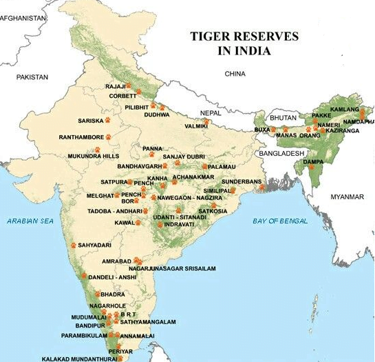
The Pilibhit Tiger Reserve which was recently awarded TX2 award for doubling the number of tigers in the past four years is in which state?
Correct
Solution (a)
TX2 award:
Launched recently, these awards were open to submissions from any site in a tiger range country that has achieved remarkable measurable progress since 2010.
Site: An area having a functional tiger population, legally designated as a “site” under national legislation.
Award winners were announced on 23rd November 2020 – the 10 year anniversary for the global TX2 goal.
Sites will receive a small financial grant to be used to further tiger conservation.
TX2 Award: It goes to one site that has achieved remarkable and measurable increase in its tiger population since 2010.
Conservation Excellence Award: This award recognises one site that has achieved excellence in two or more of these five themes:
Tiger and prey population monitoring and research (tiger translocation/prey augmentation),
Effective site management,
Enhanced law enforcement & protection & ranger welfare improvement,
Community based conservation, benefits and human-wildlife conflict mitigation and
Habitat and prey management.
Pilibhit Tiger Reserve:
Location: Pilibhit district, Lakhimpur Kheri District and Bahraich District of Uttar Pradesh
The northern edge of the reserve lies along the Indo-Nepal border while the southern boundary is marked by the river Sharada and Khakra.
Incorrect
Solution (a)
TX2 award:
Launched recently, these awards were open to submissions from any site in a tiger range country that has achieved remarkable measurable progress since 2010.
Site: An area having a functional tiger population, legally designated as a “site” under national legislation.
Award winners were announced on 23rd November 2020 – the 10 year anniversary for the global TX2 goal.
Sites will receive a small financial grant to be used to further tiger conservation.
TX2 Award: It goes to one site that has achieved remarkable and measurable increase in its tiger population since 2010.
Conservation Excellence Award: This award recognises one site that has achieved excellence in two or more of these five themes:
Tiger and prey population monitoring and research (tiger translocation/prey augmentation),
Effective site management,
Enhanced law enforcement & protection & ranger welfare improvement,
Community based conservation, benefits and human-wildlife conflict mitigation and
Habitat and prey management.
Pilibhit Tiger Reserve:
Location: Pilibhit district, Lakhimpur Kheri District and Bahraich District of Uttar Pradesh
The northern edge of the reserve lies along the Indo-Nepal border while the southern boundary is marked by the river Sharada and Khakra.
Question 3 of 5
3. Question
Chhath Puja was recently in news, is related to which god?
Correct
Solution (b)
Chhath is a Hindu festival dedicated to the Sun god and his wife Usha in order to thank them for bestowing the bounties of life on earth.
The word chhath means sixth and the festival is celebrated on the sixth day of the month Kartika of the Hindu lunar Bikram Sambat calendar.
The festival is observed over a period of four days, Goddess Chhathi Maiya is worshipped during the Chhath Puja.
The main worshipers, called Parvaitin, are usually women.
However, many men also observe this festival as Chhath is not a gender-specific festival.
The rituals include holy bathing, fasting, standing in water for long periods of time, and offering prayers and food to the setting and rising sun.
The festival is observed most elaborately in Mithila Province of Nepal, Terai-Madhesh region of Nepal, Indian states of Bihar, Jharkhand and UP.
Incorrect
Solution (b)
Chhath is a Hindu festival dedicated to the Sun god and his wife Usha in order to thank them for bestowing the bounties of life on earth.
The word chhath means sixth and the festival is celebrated on the sixth day of the month Kartika of the Hindu lunar Bikram Sambat calendar.
The festival is observed over a period of four days, Goddess Chhathi Maiya is worshipped during the Chhath Puja.
The main worshipers, called Parvaitin, are usually women.
However, many men also observe this festival as Chhath is not a gender-specific festival.
The rituals include holy bathing, fasting, standing in water for long periods of time, and offering prayers and food to the setting and rising sun.
The festival is observed most elaborately in Mithila Province of Nepal, Terai-Madhesh region of Nepal, Indian states of Bihar, Jharkhand and UP.
Question 4 of 5
4. Question
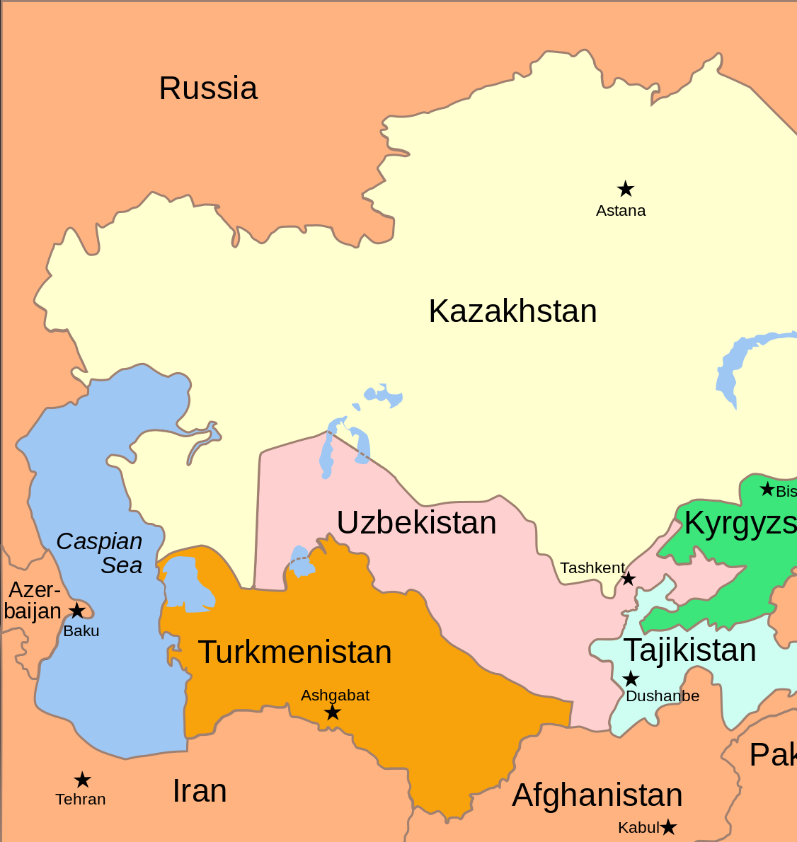
Arrange the following Places from North to South:
Kabul
Astana
Tashkent
Ashgabat
Which of the following order is/are correct?
Correct
Solution (b)
Incorrect
Solution (b)
Question 5 of 5
5. Question
Consider the following Statements with respect to Electronic Vaccine Intelligence Network (eVIN):
eVIN is an indigenously developed technology
WHO is associating with India under this Mission
Which of the above statements is/are correct?
Correct
Solution (a)
The Indian government is using eVIN (Electronic Vaccine Intelligence Network) in association with the United Nations Development Program (UNDP) to identify primary beneficiaries and vaccine distribution networks.
eVIN is an indigenously developed technology.
It digitises vaccine stocks and monitors the temperature of the cold chain through a smartphone application.
The innovative eVIN was first launched across 12 states in 2015 to support better vaccine logistics management at cold chain points.
eVIN supports the central government’s Universal Immunization Programme by providing real-time information on vaccine stocks and flows, and storage temperatures across all cold chain points across states and UTs.
Incorrect
Solution (a)
The Indian government is using eVIN (Electronic Vaccine Intelligence Network) in association with the United Nations Development Program (UNDP) to identify primary beneficiaries and vaccine distribution networks.
eVIN is an indigenously developed technology.
It digitises vaccine stocks and monitors the temperature of the cold chain through a smartphone application.
The innovative eVIN was first launched across 12 states in 2015 to support better vaccine logistics management at cold chain points.
eVIN supports the central government’s Universal Immunization Programme by providing real-time information on vaccine stocks and flows, and storage temperatures across all cold chain points across states and UTs.