UPSC Articles
INTERNATIONAL/ HISTORY
Topic: General Studies 1 & 2:
- Modern Indian history from about the middle of the eighteenth century
- India and its neighborhood- relations.
India-Nepal Border issue
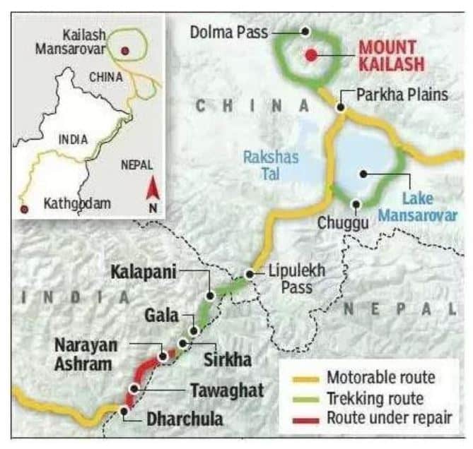
Context: The inauguration of a road from Dharchula to Lipu Lekh (China border) by India’s Defence Minister over videoconferencing on May 8th 2020. This has now been followed by Nepal’s charge claiming that the stretch passes though Nepalese territory.
Did You Know?
- The Lipulekh Pass links Uttarakhand with China’s Tibetan Autonomous Region.
- The pass is near the tri-junction of India, Nepal and China

Pic Source: Eenadu
Significance of the route:
- The conversion of the trekking route to a metalled road is a boon to both pilgrims and traders.
- At present, the travel to Kailash Mansarovar takes around two to three weeks through Sikkim or Nepal routes.
- Lipulekh route had a trek of 90 Km through high altitude terrain and the elderly yartris faced lot of difficulties.
- Now, this yatra will get completed by vehicles.
- Additionally, this road follows the traditional pilgrim route for the Kailash-Mansarovar yatra.
The Sugauli Treaty
- The Nepalese kingdom had stretched from the Sutlej river in the west to the Teesta river in the East.
- However, Nepal lost the Anglo-Nepalese War and the resulting Treaty of Sugauli, 1816 limited Nepal to its present territories.
- The Sugauli Treaty stated that Nepal ceded to British the whole of the lowlands between the Rivers Kali and Rapti.
- The Survey of India maps since the 1870s showed the area of Lipu Lekh down to Kalapani as part of British India.
- Both the Rana rulers of Nepal and the Nepalese Kings accepted the boundary and did not raise any objection with the government of India after India’s Independence
What is the present controversy?
- The present controversy has arisen since the Nepalese contest that the tributary that joins the Mahakali river at Kalapani is not the Kali river.
- Therefore, Nepal now contends that the Kali river lies further west to the Lipu Lekh pass and claims both Kalapani & Susta belong to Nepal
- By 2007, the Nepal-India Technical Level Joint Boundary Working Group agreed on 182 strip maps covering almost 98% of the boundary, except the two disputed areas of Kalapani and Susta.
Nepal’s reaction has been unusually aggressive towards India
- Force Deployment: Nepal has deployed its armed police close to Kalapani. The timing and the manner in which it was deployed has raised concerns in New Delhi
- India’s passive presence: The Indo-Tibetan Border Police is also located in Kalapani since it is close to the India-China border. Indian forces are not there because of Nepal.
- New Nepalese Maps: Nepal’s actions of authorising a new map extending its territory across an area sensitive for India’s defence, has further complicated the situation
- Political Opportunism: The controversy has given Nepal’s Prime Minister K.P. Sharma Oli an opportunity to divert attention about criticism of his own government’s shortcomings
- China’s Politics: Nepal at the behest of China has objected to India’s initiative as China is bound to benefit by deteriorating India-Nepal relations
Way Ahead
- The approval of the strip maps by the respective governments (that of the Nepalese Government is still awaited),
- The resolution of the differences of opinion over Kalapani and Susta
- Speeding up the erection of damaged or missing border pillars.
Conclusion
Compared to what was accomplished between India and Bangladesh, the India-Nepal border issues appear more easily solvable
Connecting the dots:
- China’s Belt and Road Initiative & India’s Neighbourhood First Policy
- India- Bangladesh Border (maritime & land) dispute resolution


