UPSC Articles
INTERNATIONAL/ SECURITY
Topic: General Studies 2,3:
- India and its neighborhood- relations
- Challenges in managing the borders
Galwan Valley: In depth view
Context: The deterioration in India-China relationship in recent past because of violence in Galwan Valley
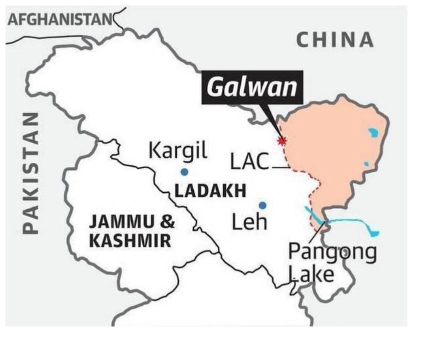
Where is Galwan Valley?
- The valley refers to the land that sits between steep mountains that buffet the Galwan River.
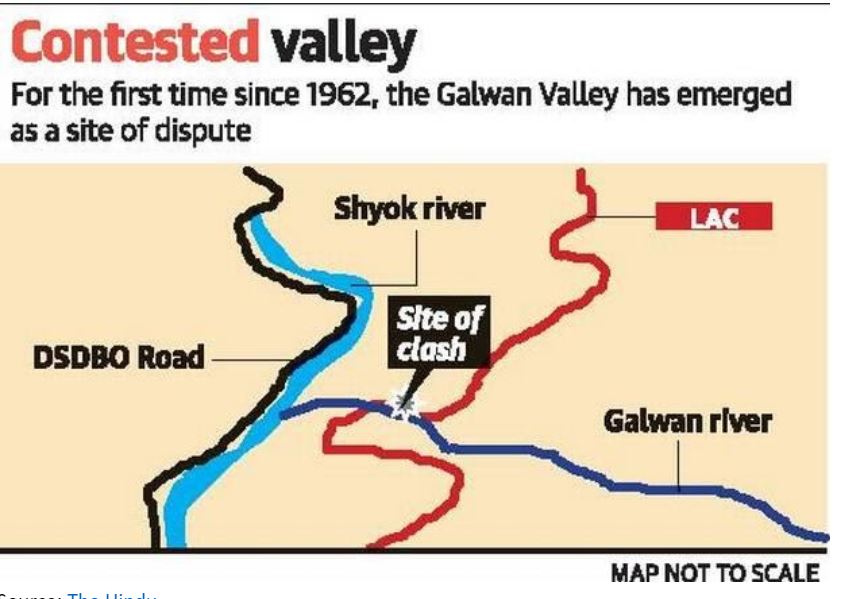
- The river has its source in Aksai Chin, on China’s side of the LAC, and it flows from the east to Ladakh, where it meets the Shyok river on India’s side of the LAC.
- The valley is strategically located between Ladakh in the west and Aksai Chin in the east (currently controlled by China)
- At its western end are the Shyok river and the Darbuk-Shyok-Daulet Beg Oldie (DSDBO) road.
- Its eastern mouth lies not far from China’s vital Xinjiang Tibet road, now called the G219 highway.

Source: The Hindu
What is the recent flare-up in this sector?
- The Line of Actual Control (LAC) lies east of the confluence of the Galwan and Shyok rivers in the valley, up to which both India and China have been patrolling in recent years.
- The LAC refers to territory under the effective control of each side, not to their entire territorial claim.
- For instance, India’s territorial claims extend 38,000 sq km on the other side of the LAC across all of Aksai Chin, but the LAC India observes runs through the valley.
- However, Beijing is now saying the entire Galwan valley is on its side of the LAC, which pegs the LAC further west near the Shyok river.
- The DSDBO road has helped India plug the infrastructure gap near the LAC region. This is being viewed with suspicion by China which wants to maintain its upper hand in the region vis-à-vis military mobilization
- India has rejected the claim as “exaggerated and untenable”.

Source: The Hindu
Are China’s claims new?
- In 1959, then Premier Zhou Enlai said a 1956 map portrayed the correct alignment. This showed the entire Galwan Valley as a part of India.
- However, in June 1960 China put out a map claiming sovereignty over the valley. A Chinese map from November 1962 also claims the entire valley, but subsequent maps have not shown the western tip of the river as a part of China.
- Therefore, most Chinese maps show most of Galwan river on China’s side of the line, but short of the confluence.
- By now staking a claim to the entire Galwan Valley and up to the confluence of the rivers, China is, in India’s view, unilaterally altering the LAC here.
Are there any initiatives to deal with this differing perception on LAC?
- According to the 1993 Border Peace and Tranquility Agreement (BPTA), India and China agreed to “strictly respect and observe the LAC between the two sides”.
- This referred to the LAC at the time, rendering irrelevant the line of actual control in 1959 or 1962
- It also says that when necessary, the two sides shall jointly check and determine the segments of LAC where they have different views as to its alignment
- Clarifying the LAC has also been explicitly codified in the 1996 agreement on confidence-building measures and subsequent agreements.
Why the problem in finding a resolution?
- China has refused to exchange maps in the western sector to take the resolution process forward.
- China appears to view an unsettled border as holding some leverage with India, one of the many pressure points it could use to keep India off-guard
Conclusion
Apart from insisting on a timely and early clarification of the LAC, India should take a long view of realigning its South Asia policy (to counter-balance China)
Connecting the dots:
- China’s Belt & Road Initiative
- India’s Act East Policy


