The Big Picture- RSTV, UPSC Articles


India, Nepal Map Row
Archives
TOPIC: General Studies 2
- India’s relation with neighbours – Nepal
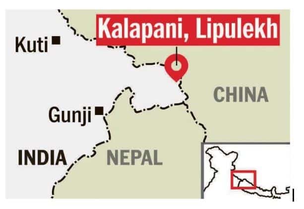
In News: The Ministry of External Affairs slammed the Nepal government’s approval of a new Nepalese map that shows territories contested with India as a part of Nepal.
- Nepal Prime Minister KP Sharma Oli asserted that Lipulekh, Kalapani and Limpiyadhura belong to Nepal and vowed to “reclaim” them from India through political and diplomatic efforts, as his Cabinet endorsed a new political map showing the three areas as Nepalese territory.
- Nepal has also claimed a large tract of land across Uttar Pradesh’s Gorakhpur in Susta as a part of its territory in the new maps and has since asked India to remove “encroachments” from the area.
- India called the move a unilateral act which is not based on historical facts and evidence. It urged Kathmandu “to respect India’s sovereignty and territorial integrity”.
Why these regions – Reprise of an old story
Modi government’s most recent gift to Hindu pilgrims is a road to reach Kailash-Manasarovar in Tibet. The road traverses territory claimed by Nepal. Hence, in a bid to assert its claim over the territory, the government of Nepal unveiled a new political map of the country which included the regions of Kalapani, Lipulekh and Limpiyadhura as part of its sovereign territory. Nepal has rejected India’s claim over these territories.
India carried out four escalatory actions in a row –
- First, in May 2015 it signed an agreement with China to use the Lipu Lekh Pass for trade; Kathmandu immediately protested to both New Delhi and Beijing.
- Second, in November 2019 India published a new map that showed Kalapani within its territory.
- Third, India’s defence minister Rajnath Singh inaugurated a road link to Lipu Lekh amid Covid-19 and an ongoing political crisis in Kathmandu.
- Fourth was the statement by Indian Army Chief General M.M. Naravane, implying China had instigated Nepal to lay claims on the area.
However, India’s sovereignty over the Lipulekh Pass is yet to be established as it continues to be a disputed region.
- India’s claims do not acknowledge the fact that, in the last 26 years of discussions, the Nepal-India Joint Technical Level Boundary Committee, which was able to settle nearly 97% of the border, has failed to resolve the dispute over Kalapani and Susta.
- In 2009, the then Indian external affairs minister, Pranab Mukherjee, on a visit to Nepal said that both sides had “agreed to resolve the long standing border disputes between the two countries at various places, including Kalapani and Susta through further discussions.”
- The Lipulekh Pass, which lies at the centre of the current dispute, is situated at an altitude of 5,000 metres. Nepal claims that the Indian army has encroached 372 square kilometres towards Limpiyadhura from Kalapani since the 1962 Indo-China war. At that time, Nepal, as a friendly neighbour, granted permission to the Indian army to set up a camp in the region.
- Subsequently, despite several firm requests by Nepal’s prime minister at the time, Kirti Nidhi Bista, to evacuate the camp, Indian troops stayed put. Because of the asymmetric power relationship between the two countries, Nepal has not been able to force India to withdraw its troops from the area.
Treaty of Sugauli
Demarcation of the modern India-Nepal border began on March 4, 1816, after the Treaty of Sugauli was signed between the British East India Company and the Kingdom of Nepal in 1911. The treaty, which declared the Mahakali River of Nepal as the border between the two countries, was expected to resolve border issues. It didn’t.
Can rivers be the decision makers?
The Kali River is formed by the union of two headwaters: the Kalapani river that originates below the Lipulekh Pas and the Kuthi Yankit river that rises below the Limpiyadhura range. Both the streams have been termed ‘Kali River’ on different occasions. The Kali River serves as the boundary between Uttarakhand (Kumaon region) and Nepal from Limpiyadhura (30.227°N 80.920°E). The Lipulekh pass, as well as the Limpayadhura pass (or Limpiya pass), are on Nepal border with Tibet.
In addition to Mahakali/Sharda (West), Gandak/Narayani (South) and Mechi (East) are two other rivers which demarcate the border between India and Nepal. Around 600 kilometres of the India-Nepal border is defined by rivers: the Mechi in the east, Mahakali in the west, and Naryani in the Susta area.
Over the decades, these rivers have changed courses several times, giving rise to disputes, claims and counterclaims on land. The Nepal government claims that by taking advantage of Nepal’s negligence in guarding its borders, India has encroached on its borderland. Reports from Nepal claim that Indians from UP and Bihar have encroached on over 60,000 hectares of land in 23 out of the 75 bordering districts.
This is a classic case of misunderstanding between two friends who share open borders and free movement of people.
The former director-general of the Department of Survey of Nepal, claims that maps from 1850 and 1856, prepared by the Survey of India with the participation of Nepali authorities, clearly state that the Mahakal River originates from Limpiyadhura, 16 km northwest of Kalapani, thereby proving that Kalapani belongs to Nepal.
However, India has consistently refused to accept those maps as proof. Indian officials insist that a map drawn up by the British colonial government in 1875 should be considered instead. This map allegedly shows the origin of the Mahakali River to the east of Kalapani. Unlike the maps from 1850 and 1856, the 1875 map does not have Nepal’s certification.
The Way Forward
As both countries are laying claim to the same piece of land, the time has come for both countries to sit for talks to solve this issue. This time, the Prime Minister of Nepal should hold a direct conversation with his Indian counterpart Narendra Modi to resolve the territorial issue.
Nepal should come up with all historical evidence available and present its case. Due to political instability in Nepal and India’s strong influence in domestic politics, Nepal’s leaders were reluctant to discuss this issue seriously. Nepal should be ready to face India and India should be ready to hold serious bilateral dialogues to resolve this issue.
Connecting the Dots:
- What is the strategic importance of the region? Why do both sides stake claim to the area? Discuss.
- It’s time for India and Nepal to hold talks on the border issue. Discuss.


