Science and Technology

Context: Recently consultative committee of Ministry of Civil Aviation meets in New Delhi to discuss GAGAN (GPS Aided Geo Augmented Navigation).
About GAGAN:
- GAGAN is an acronym for GPS Aided GEO Augmented Navigation.
- It is a Space Based Augmentation System (SBAS) jointly developed by ISRO and AAI to provide the best possible navigational services over Indian FIR (Flight Information Region) with the capability of expanding to neighbouring FIRs.
- GAGAN is a system of satellites and ground stations that provide GPS signal corrections, giving you better position accuracy.
- GPS alone does not meet the ICAOs navigational requirements for accuracy, integrity and availability.
- GAGAN corrects for GPS signal errors caused by Ionospheric disturbances, timing and satellite orbit errors and also it provides vital information regarding the health of each satellite.
Services Offered under GAGAN:
- Aviation, Forest management, Railways signalling, Scientific Research for Atmospheric Studies, Natural Resource and Land Management, Location based services, Mobile, Tourism.
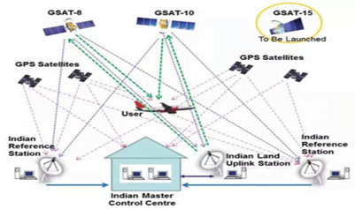
How it works?
- GAGAN consists of set of ground reference stations positioned across various locations in India called Indian Reference Station (INRES), which gathers GPS satellite data.
- A master station, Indian Master Control Centre (INMCC) collects data from reference stations and create GPS correction messages.
- The corrected differential messages are uplinkeded via Indian Uplink Station (INLUS) and then broadcasted on a signal from three geostationary satellites (GSAT-8, GSAT-10 and GSAT-15).
- The information on this signal is compatible with basic GPS signal structure, which means any SBAS enabled GPS receiver can read this signal.
Coverage Area:
- Two GEOs simultaneously transmit the GAGAN signal in space. GAGAN GEO footprint expands from Africa to Australia and GAGAN system has capability to cater 45 reference stations for expansion to neighbouring countries.
- GAGAN provides a civil aeronautical navigation signal consistent with International Civil Aviation Organization (ICAO) Standards and Recommended Practices (SARPs) as established by the Global Navigation Satellite System (GNSS) Panel.
- The GAGAN system provides Non-precision approach (NPA) service accurate to within the radius of 1/10th of a nautical mile (Required Navigation Performance or RNP-0.1) over the Indian FIR as well as precision approach service of APV-1.0 (Approach with Vertical guidance) over the Indian landmass on nominal days.
- The system is interoperable with other international SBAS systems such as the S. Wide Area Augmentation System (WAAS), the European Geostationary Navigation Overlay Service (EGNOS), and the Japanese MTSAT Satellite Augmentation System (MSAS), and provides seamless air navigation across regional boundaries.
Source: PIB
Previous Year Question
Q.1) With reference to the Indian Regional Navigation Satellite System (IRNSS), consider the following statements:
- IRNSS has three satellites in geostationary and four satellites in geosynchronous orbits.
- IRNSS covers entire India and about 5500 sq. km beyond its borders.
- India will have its own satellite navigation system with full global coverage by the middle of 2019.
Which of the statements given above is/are correct? (2018)
- 1 only
- 1 and 2 only
- 2 and 3 only
- None


