Uncategorized

TLP: GEOGRAPHY SYNOPSIS [DAY 8, 9 & 10]
Geography TLP: Day 8 synopsis
3. Examine the causes of environmental degradation in hill areas. Suggest an appropriate development strategy for the hilly tracts of India. (25 marks)
Directives: the first part of the question is easy as it asks you to simply enumerate the causes of environmental degradation. The most important ones are:
- Shifting cultivation
- Soil erosion due to deforestation and overgrazing
- Construction of dams and reservoirs
- Slope destabilization due to rampant and uncontrolled construction of roads and buildings giving rise to landslides
- Mining activities
- Rivers in the hilly region are getting polluted due to polluting industries and residential areas located on their banks
- Growing influx of tourism
- Loss of biodiversity due to anthropogenic activities and so on
The second part is a bit tricky though. You can be as innovative as possible. It was sad to see hardly anyone giving examples in this question. Your policy prescriptions must be clubbed with suitable examples. Moreover, a brief discussion on the concept of sustainable hill area development in the beginning would have been better. Nevertheless, here are some pointers to this sustainable strategy:
- Ecosystem approach to hill area development
- Tackling special problems in an integrated manner to address steep terrain, soil erosion, fluctuating water table etc by preventing shifting cultivation, deforestation, overgrazing etc
- Modifying the livestock composition to suit local conditions
- Prevention of forest cover to be lost as fuel wood by creating alternative sources of energy
- Fodder and seed development plans as per local conditions
- Development of rural industries based on local skills and resources
- Horticulture and plantation crops
- Cost of infra development to be minimized
- Preservation of sustainable livelihood and ease the drudgery of the people of HAs etc
4. What do you understand by watershed management? Explain its components. What are the challenges being faced in its implementation at the grass-root level? What can be done to address these challenges. (25 marks)
Directives: This is a simple and straight question. The fodder for this question is available in standard geography books. Still we provide you with some pointers. Expand them yourself.
Watershed development objectives:
- Ecological
- Economy
- Employment
- Equity
- Export
Components:
- Geomorphological
- Plantation management
- Energy management
- Livestock management
- Agricultural management
- Social management
Challenges
- Lack of social cohesion
- Lack of community participation
- Violation of rules and arising conflicts
- Watershed committee leadership disputes
As far as suggestions are concerned, you can come up with as many as you want.
5. On an outline map, show the distribution of tribal population in India. What do think are the challenges for developing these areas? Critically examine the strategies adopted for the development of tribal areas in India. (25 marks)
Directives: The map part was easy. Many of you need to better your map drawing skills. It will improve your marks. The second part is also easy as you were supposed to simply count the challenges being faced by tribal areas due to lack of development or as a result of development.
Most you didn’t do well in dealing with the part asking for the critical examination of tribal area development strategies. First you were required to discuss in brief the philosophical basis that prompted for the adoption of tribal area development plans. Then, you were supposed to provide an analysis of the successes and failures of various initiatives including the Tribal Sub Plan.
In conclusion, you could provide a brief explanation as to how the strategies should evolve to take into account the issues of sustainability, cultural identity and uniqueness, livelihood, human development etc.
Geography TLP: Day 9 synopsis
3. The constitution of NITI Aayog would go a long way in ensuring the balance between the developmental imperatives and decentralized planning in India and also keeping intact the federal philosophy. Critically comment (25 marks)
Directives: In the initial para, you were required to discuss as to how the decades old planning process in India was essentially a centralized one and dissociated from ground reality. You must keep in mind that you are writing a geography answer. Your treatment of the limitations of the earlier planning process must take into account the fact that planning process in India somehow neglected the geography of an area and that itself was a result of the centralized planning process. Examples of plantation of eucalyptus, indiscriminate use of fertilizers, development of irrigation in not so suited regions, extraction of groundwater for irrigation, construction of dams and reservoirs without taking into account local environmental problems and people’s aspirations etc were result of centralized planning. You were also supposed to deal the federal imbalance created by the planning process. A brief reference to the geographical basis of federalism would have improved your answer.
In the second part, an analysis of the philosophy behind the constitution of NITI Aayog was required. Mention of the following points along with their explanation was needed:
- Increased role of states in the planning process
- More focus on collaborative action and cooperative federalism
- Idea of giving high weightage to local needs and aspirations
- Idea of pilot projects
- Idea of incorporating best practices from different parts of the country
4. The River Interlinking Project (RIP), if not suitably modified to Indian physiography and climate, is fraught with severe ecological hazards. In light of the given statement, analyse the pros and cons of RIP in India. (25 marks)
Directives: the question is highly specific and required a specific answer. You were required to deal only with an ecological view point.
Pros: very few
- Rejuvenation of river ecosystems in otherwise dry basins
- Groundwater recharge in otherwise dry basins due to transfer of water from the surplus region during dry season
- Protection from floods and droughts
Other benefits are only socio-economic which all of you know but need not mention here. Our focus has to be on the cons of this plan which are lot too many. The most important ones are:
- Millions of years of ecological balance would be disturbed
- Problem of sedimentation and bio-nutrient loss due to construction of dams
- Loss of ecological niche of the downstream regions
- Loss of all benefits accruing from river flooding
- Adverse impact on agriculture
- Rise in hydraulic gradient making groundwater replenishment increasingly difficult
- Submergence of forested areas due to construction of dams
- Altered monsoon patterns due to increased salinity and reduced evaporation
- Marine transgression
- Coastal delta erosion by sea waves due to lack of sediment supply
- Break in the symbiotic relationship between marine and plant life systems on the earth.
5. Given a chance to create a group of special category states, what geographical basis would you adopt? Also discuss the possible strategies that you would recommend for their development. (25 marks)
Directives: This was an open ended question. There was no limit imposed to your imagination. The only thing required was to impart your answer a complete geographical outlook. It is possible if you incorporated the following aspects:
- Population
- Forest cover
- Agricultural potential
- Resource endowment
- Strategic location
- Industrial development status and potential
- Energy potential
- Presence of hilly/ difficult terrain
- Proportion of tribal population
- Harsh climate etc
Similarly, even the second part could be dealt by providing as many sustainable solutions as possible.
Geography TLP: Day 10 synopsis
This was your first day for physical geography. Unlike human geography where there can be many perspectives to a question and you could provide as many dimensions as possible, majority of the portions in physical geography are fact based and governed by natural forces. In fact physical geography deals with these forces and their impact on the landscape. Therefore, there is not much that can be provided as synopsis for synopsis except for some directives to improve your presentation. Therefore, in this phase, we will be very brief with our synopsis.
3. Write a short note on the heat budget of the earth. Also discuss the anthropogenic factors that are responsible for disrupting this balance. What are its consequences? (25 marks)
Directives: A very basic question and thus a tricky one. How will you ensure that you get above average marks in this question? Only one solution: use innovative diagrams and flowcharts. Don’t write the answer as a 10th standard student. Be more descriptive, innovative and precise. We found a good image on google for your reference. You can use it in your answers.
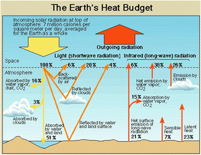
The second part was only a modified statement that was asking you to enumerate the causes and consequences of global temperature change.
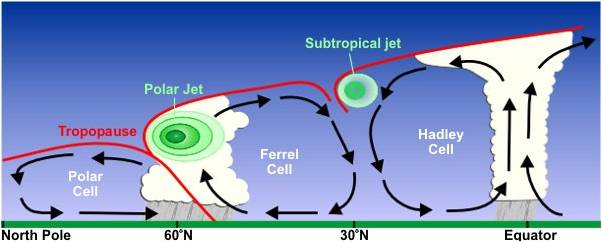
4. How jet streams are formed? What impacts do jet streams have on climate of the world? (15 marks)
Directives: Again a very simple and basic question. The idea is to inculcate in you the habit of dealing easy questions differently so as to make you stand different from the crowd. However, we found very general answers. Try to be more innovative. For diagrams, nothing better than google images:
5. Discuss the models that are used to explain atmospheric pressure and circulation. Also enumerate their merits and limitations. (25 marks)
Directives: This question required an in and out analysis of all the models including their assumptions, merits, limitations, modifications etc. Diagrams were supposed to play the most important role here.