IASbaba's Think Learn and Perform 2017, UPSC Mains Answer Writing

SYNOPSIS: IASbaba’s TLP – 2017 : UPSC Mains General Studies Questions [5th Sep, 2017]- Day 42
Archives
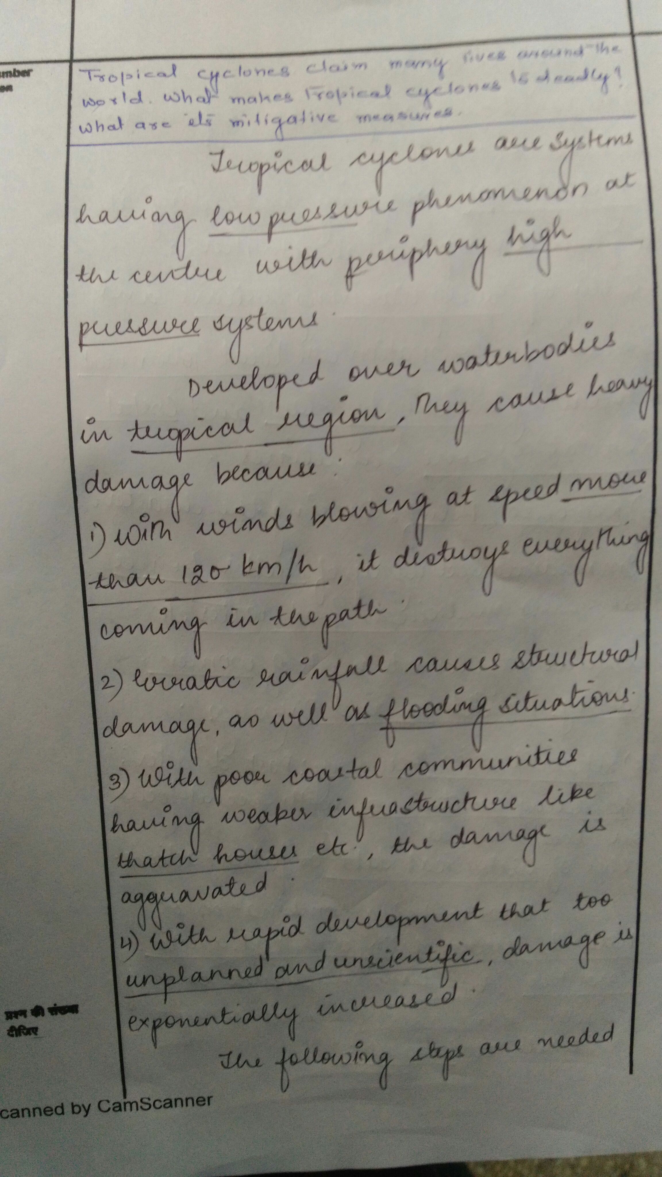
1. Tropical cyclones claim many lives around the world. What makes tropical cyclones to deadly? What are its mitigative measures.
Introduction:
A tropical cyclone is a rapidly rotating storm system characterized by a low-pressure center, a closed low-level atmospheric circulation, strong winds, and a spiral arrangement of thunderstorms that produce heavy rain. Depending on its location and strength, a tropical cyclone is referred to by names such as hurricane , typhoon, tropical storm, cyclonic storm, tropical depression, and simply cyclone.
The latest incident of Hurricane Harvey hitting the east coast USA is said to have damaged more than 185,000 homes and ticking. India sees landfall of these cyclones every year- Cyclone Vardah(2016), Phailin in Odisha (2013) and Hudhud in Andhra Pradesh (2014).
What makes tropical cyclones deadly?
- Within sea it destroys ships, oil rigs falling into its way.
- Heavy downpour on landfall.
- Rapid movement of air. Wind speed more than 120 km/hr
- Strom surges
- Unpredictable nature adds to its deadliness.
- Further given the fact that in India coastal regions are heavily populated by poor people mainly fishing communities the vulnerability of human population further increases.
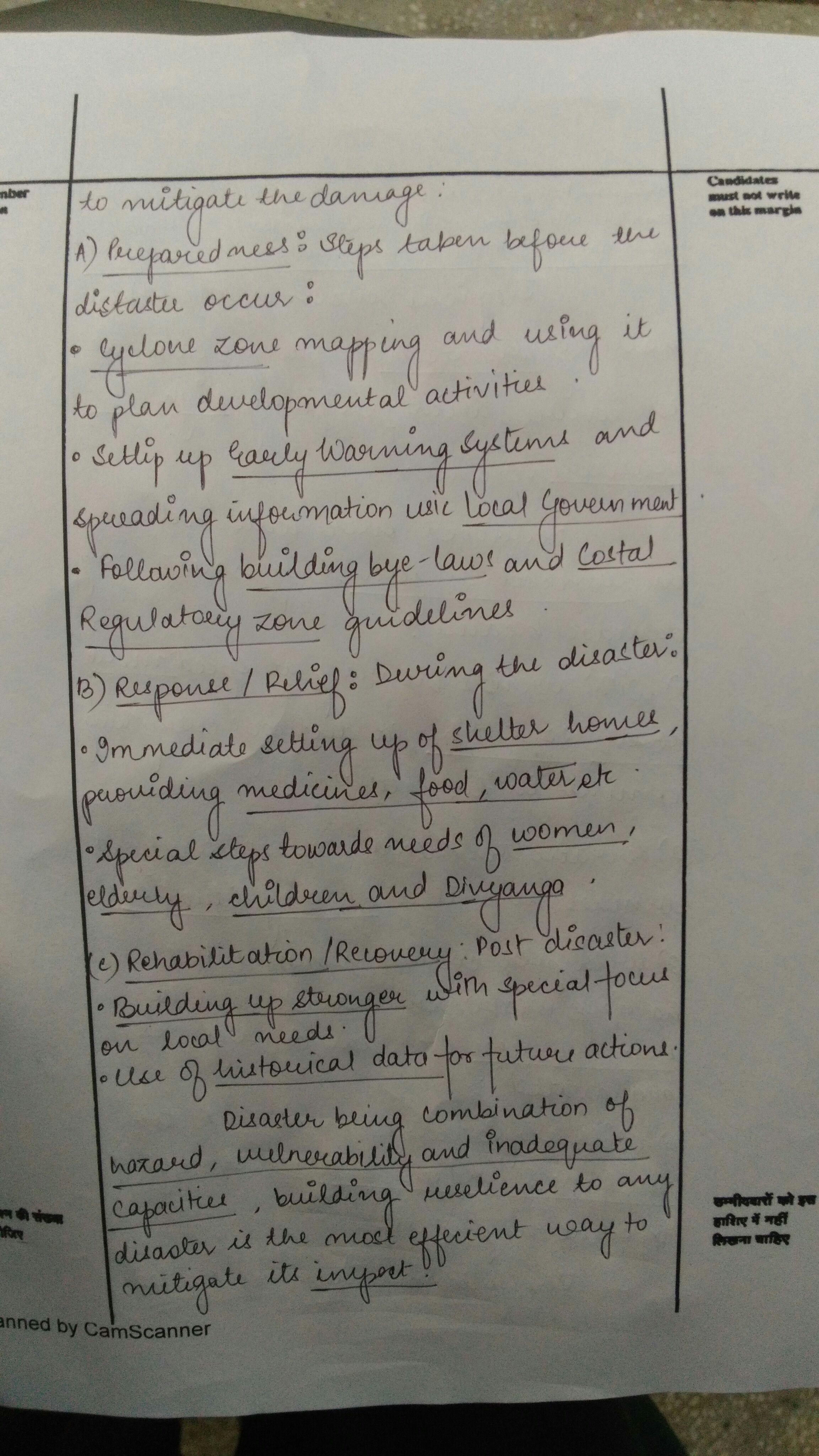
Mitigative measures:
- Cyclone zone mapping and going for plan development.
- Forecasting along with proper warning systems. Efficient satellite tracking of cyclones. Early warning system to initiate mitigation measures with as much lead time as possible
- Training of National disaster response force and the civil society to help eachother in a well-coordinated evacuation effort.
- Awareness generation.
- Plenty of Shelters for the displaced population and availability of the basic needs such as food, water and sanitation.
- Structural interventions- structures which are able to withstand high wind speed of cyclones should be built in coastal areas.
- Plantation of mangroves.
- Checking illegal construction nearby coasts.
- Implementation of Sendai framework which calls for community participation so as to avoid risks in the wake of a disaster.
Conclusion:
Tropical cyclone being a natural disaster cannot be prevented however proper steps as mentioned above can go a long way to reducing its deadliness.
Best answer: Akhil Pareek
2. The hazards associated with earthquakes get aggravated by a number of factors. Can you enumerate these factors? Also discuss the measures to mitigate earthquakes.
SYNOPSIS:
Few natural disasters can match the destructive powers of an earthquake. In addition to causing widespread havoc, severe casualties and destroy country’s infrastructure UNDP report says between 2005-2015 around 7% of world’s GDP has been lost due to earthquakes, which can be further aggravated due to the following factors.
a)Geographic factors:
- Location: an earthquake that hits in a populated area is more likely to do damage than one that hits an unpopulated area or the middle of the ocean.
- Magnitude:. The more energy in an earthquake, the more destructive it can be.
- Depth. In general, deeper earthquakes are less damaging because their energy dissipates before it reaches the surface. The recent Nepal earthquake is an example of a shallow quake causing devastation.
- Distance from the epicenter: The epicenter is the point at the surface right above where the earthquake originates and is usually the place where the earthquake’s intensity is the greatest.
- Local geologic conditions: The nature of the ground at the surface of an earthquake can have a profound influence on the level of damage. Loose, sandy, soggy soil, like in Mexico City, can cause liquefaction and cause widespread damage.
- Secondary effects: Earthquakes can trigger landslides, fires, floods or tsunamis.
- b) Anthropogenic factors:
- Architecture: Even the strongest buildings may not survive a bad earthquake, but architecture plays a huge role in what and who survives a quake. The January 2010 Haiti earthquake, for example, was made far worseby poor construction, weak cement and unenforced building codes
- The absence of warning systems and lack of public awareness on earthquake risks.
- Location of settlements in seismic areas and size of the population
- Dense concentration of building with high occupancy.
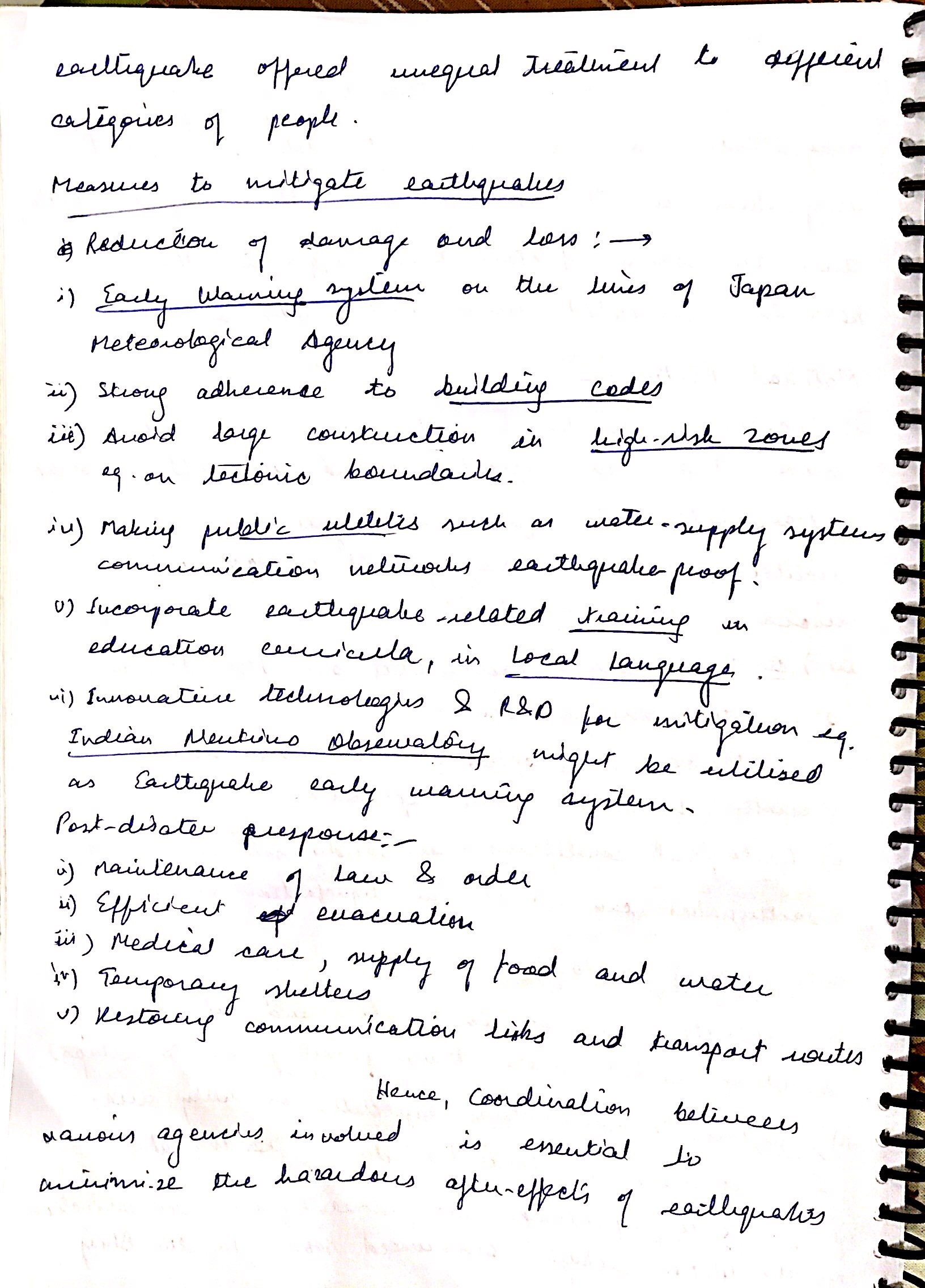
MITIGATION:
The Sendai framework for disaster risk reduction places priority on locally available solutions and revised building codes .The UNSIDR report says that mitigation can be appropriately addressed by following the these practices
- Installation of AEWS(Advanced early warning systems)
- Hazard mapping by identifying seismic zones and vulnerability atlas
- There is a need to constitute a core group to establish a strategy and plan of action – there is a need to revise building codes and adopt seismic retrofitting
- Getting communities involved in the process of disaster mitigation through education and awareness. Networking of local NGOs working in the area of disaster management.
- Supporting R&D in various aspects of disaster mitigation, preparedness and prevention and post-disaster management.
- Evolving educational curricula in architecture and engineering institutions and technical training in polytechnics and schools to include disaster related topics.
Ultimately the capacity to manage disaster risks depends on good governance and the best way to do it is to involve and empower citizens and build partnerships with civil society and the private sector.
BEST ANSWER: REDEEMER 911
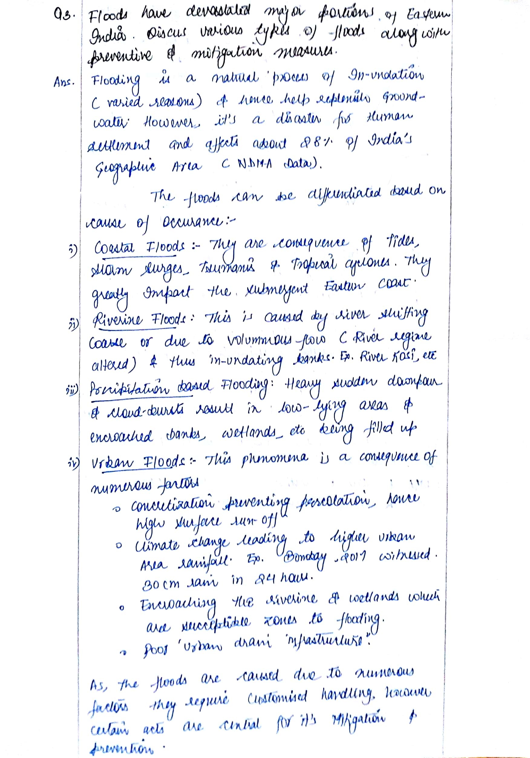
3. Floods have devastated major portions of Eastern India. Discuss various types of floods along with their preventive and mitigative measures.
What do you mean by “Flood”?
It is a temporary inundation of large regions as a result of an increase in reservoir, or
of rivers, flooding their banks because of heavy rains, high winds, cyclones, storm surge
along coast, tsunami, melting snow or dam bursts.
Types of Floods
Flash floods:
It is defined as floods which occur within six hours of the beginning of heavy rainfall , and are usually associated with cloud bursts, storms and cyclones requiring rapid localized warning and immediate response if damage is to be mitigated. In case of flash floods, warning for timely evacuation may not always be possible.
River floods:
Such floods are caused by precipitation over large catchment areas. These floods normally build up slowly or seasonally and may continue for days or weeks as compared to flash floods.
Coastal floods:
Some floods are associated with the cyclonic activities like hurricanes, tropical cyclone etc. Catastrophic flooding is often aggravated by wind-induced storm surges along the coast.
Causes of Flood:
Excessive rainfall in river catchments or concentration of runoff from the tributaries
and river carrying flows in excess of their capacities
Back movement of water in tributaries at their confluence with the main river
Synchronization of flood peaks of the main rivers and tributaries
Landslides causing obstruction to flow and change in the river course
Poor natural drainage
Cyclone and very intense rainfall
Intense rainfall when river is flowing full
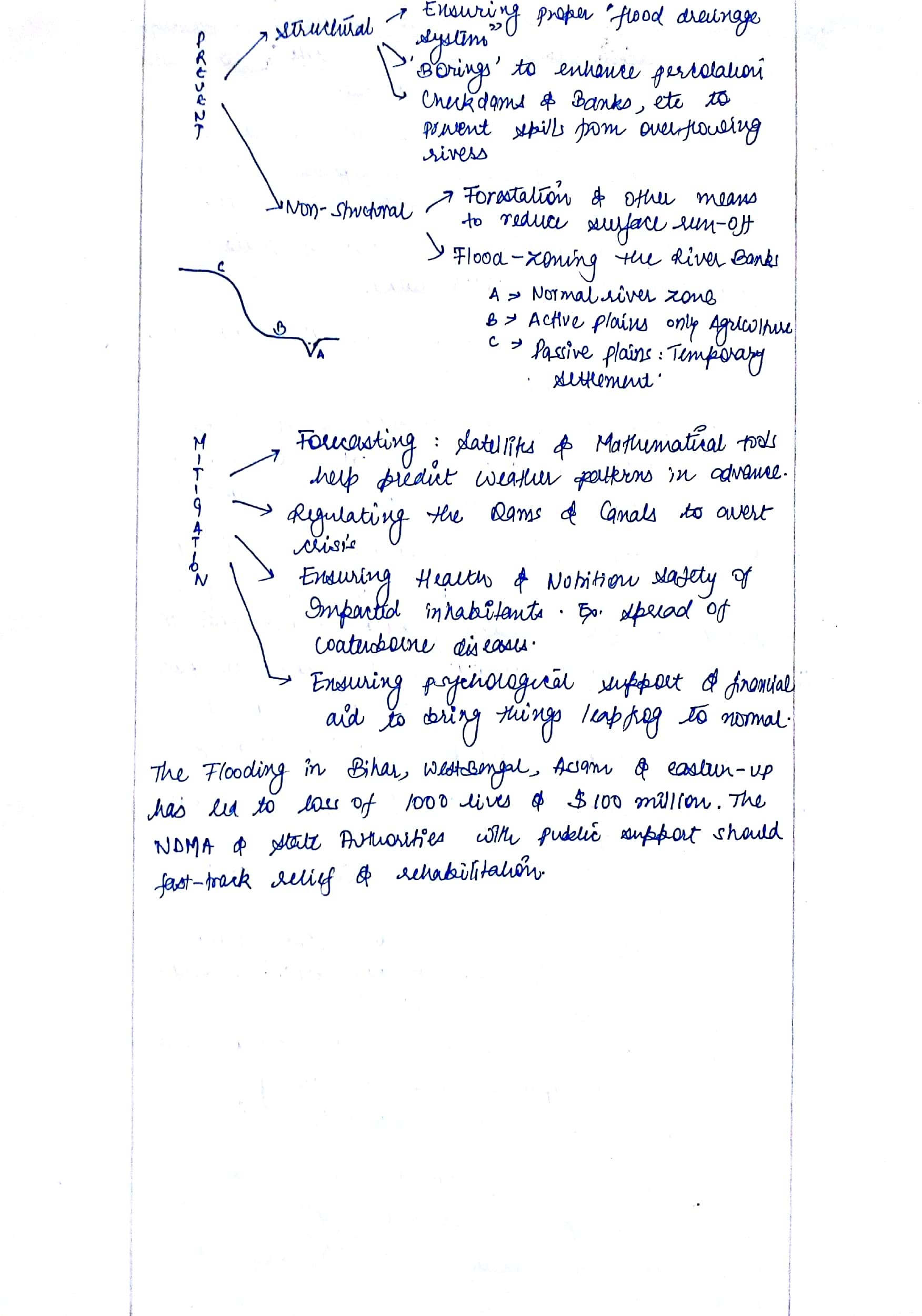
Approach to Flood Management/Prevention
Structural Measures: Attempts to Modify Flood
(a) Dams and Reservoirs
(b) Embankment
(c) Drainage Improvements
(d) Channel Improvements
(e) Diversion of Flood Waters
(f) Using Natural Detention Basin
Non- Structural Measures: Attempts to modify susceptibility of Flood
(a) Flood plain zoning: – It aims to regulate the developments in the flood plains, so that it is compatible with Flood Risk. It recognises the basic fact that the flood plains are essentially the domain of the river, and as such all developmental activities must be compatible with the flood risk involved
(b) Flood forecasting :- Involves observing and collecting hydrological and meteorological data, transmission and then processing the data with a view to work out the likely level to be achieved at a particular site, i.e. to give advance warning
(c) Flood Proofing:- It is essentially a combination of structural change and emergency action without evacuation. A programme of the flood proofing provides the raised platforms for flood
shelter for men and cattle and raising the public utility installations above flood levels.
(d) Attempts to modify loss burden by way of Disaster relief, Flood fighting, Flood insurance
Main Mitigation Strategies for Flood Disaster Management
Mapping of flood prone areas is a primary step involved in reducing the risk of the region.
Historical records give the indication of flood inundation areas and the period of occurrence and the extent of the coverage.
The basic map is combined with other maps and data to form a complete image of the flood-plain.
Warning can be issued looking into the earlier marked heights of the water levels in case of potential threat. In the coastal areas, the tide levels and land characteristics will determine areas liable to inundation.
Flood hazard mapping will give the proper indication of water flow during floods.
Best Answer: NKY
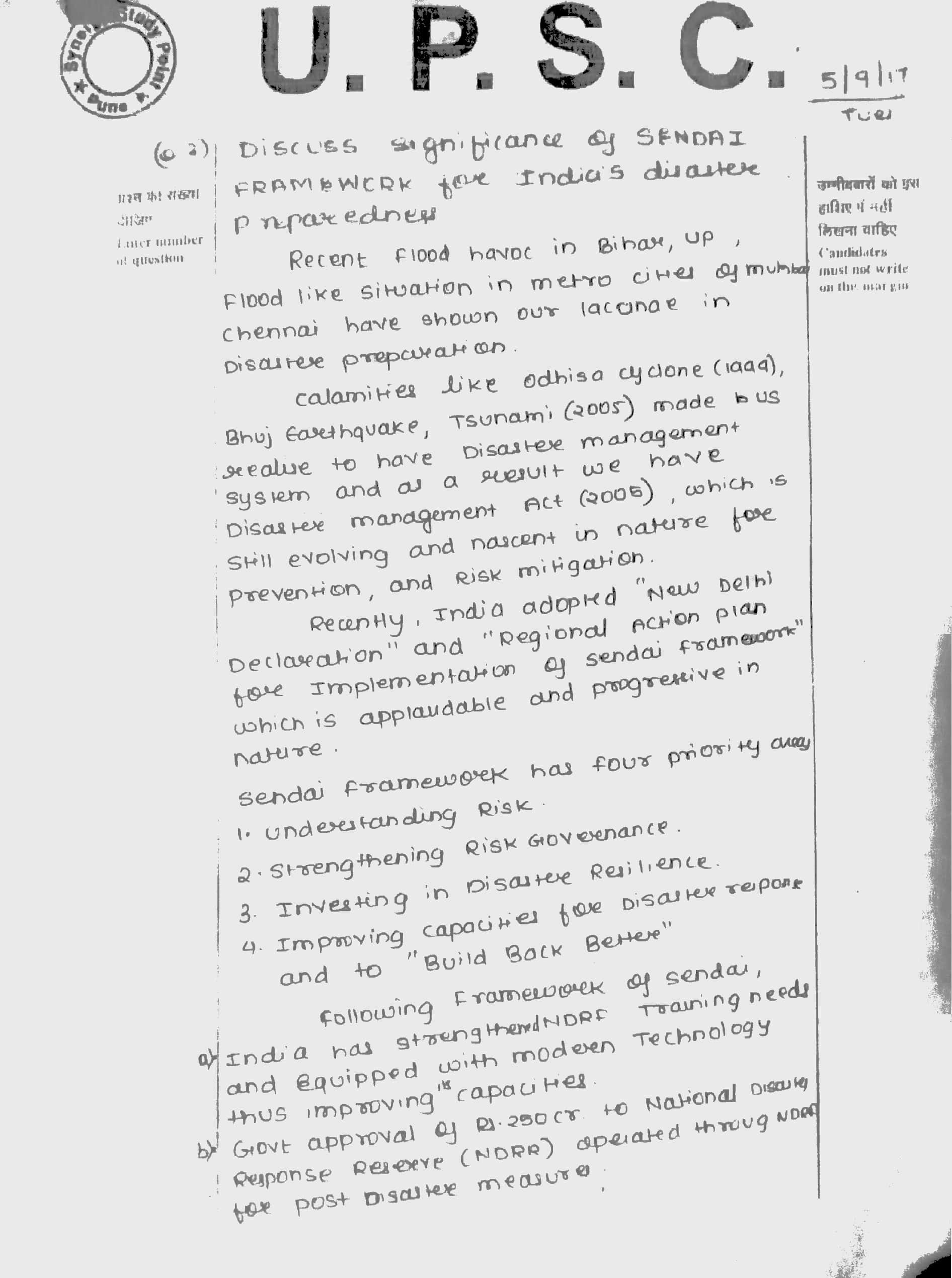
4. Discuss the significance of the Sendai Framework for India’s disaster preparedness.
- What is Sendai framework:
Sendai Framework is a 15 year (2015-2030) non-binding voluntary agreement which recognizes that states has the primary role to reduce disaster risk an also that responsibility of disaster should be shared with other stakeholders such as private sector, local governments and other stakeholders.
- It consists of 7 global targets and 4 priorities for action:
- The Seven Global Targets:
(a) Substantially reduce global disaster mortality by 2030, aiming to lower average per 100,000 global mortality rate in the decade 2020-2030 compared to the period 2005-2015.
(b) Substantially reduce the number of affected people globally by 2030, aiming to lower average global figure per 100,000 in the decade 2020 -2030 compared to the period 2005-2015.
(c) Reduce direct disaster economic loss in relation to global gross domestic product (GDP) by 2030.
(d) Substantially reduce disaster damage to critical infrastructure and disruption of basic services, among them health and educational facilities, including through developing their resilience by 2030.
(e) Substantially increase the number of countries with national and local disaster risk reduction strategies by 2020.
(f) Substantially enhance international cooperation to developing countries through adequate and sustainable support to complement their national actions for implementation of this Framework by 2030.
(g) Substantially increase the availability of and access to multi-hazard early warning systems and disaster risk information and assessments to the people by 2030.
- The Four Priorities for Action
Priority 1. Understanding disaster risk
Disaster risk management should be based on an understanding of disaster risk in all its dimensions of vulnerability, capacity, exposure of persons and assets, hazard characteristics and the environment. Such knowledge can be used for risk assessment, prevention, mitigation, preparedness and response.
Priority 2. Strengthening disaster risk governance to manage disaster risk
Disaster risk governance at the national, regional and global levels is very important for prevention, mitigation, preparedness, response, recovery, and rehabilitation. It fosters collaboration and partnership.
Priority 3. Investing in disaster risk reduction for resilience
Public and private investment in disaster risk prevention and reduction through structural and non-structural measures are essential to enhance the economic, social, health and cultural resilience of persons, communities, countries and their assets, as well as the environment.
Priority 4. Enhancing disaster preparedness for effective response and to “Build Back Better” in recovery, rehabilitation and reconstruction
The growth of disaster risk means there is a need to strengthen disaster preparedness for response, take action in anticipation of events, and ensure capacities are in place for effective response and recovery at all levels. The recovery, rehabilitation and reconstruction phase is a critical opportunity to build back better, including through integrating disaster risk reduction into development measures.
India is suffering from both man-made and natural disasters. Hence, Sendai surely is significant as it will give opportunity for global cooperation, tech transfer for early warning, risk analysis, community awareness and resilience, providing direction and vision for domestic legislation, will help in ensuring food security and having a socio-economic-political-environmental impact.
Best Answer: Raghu.
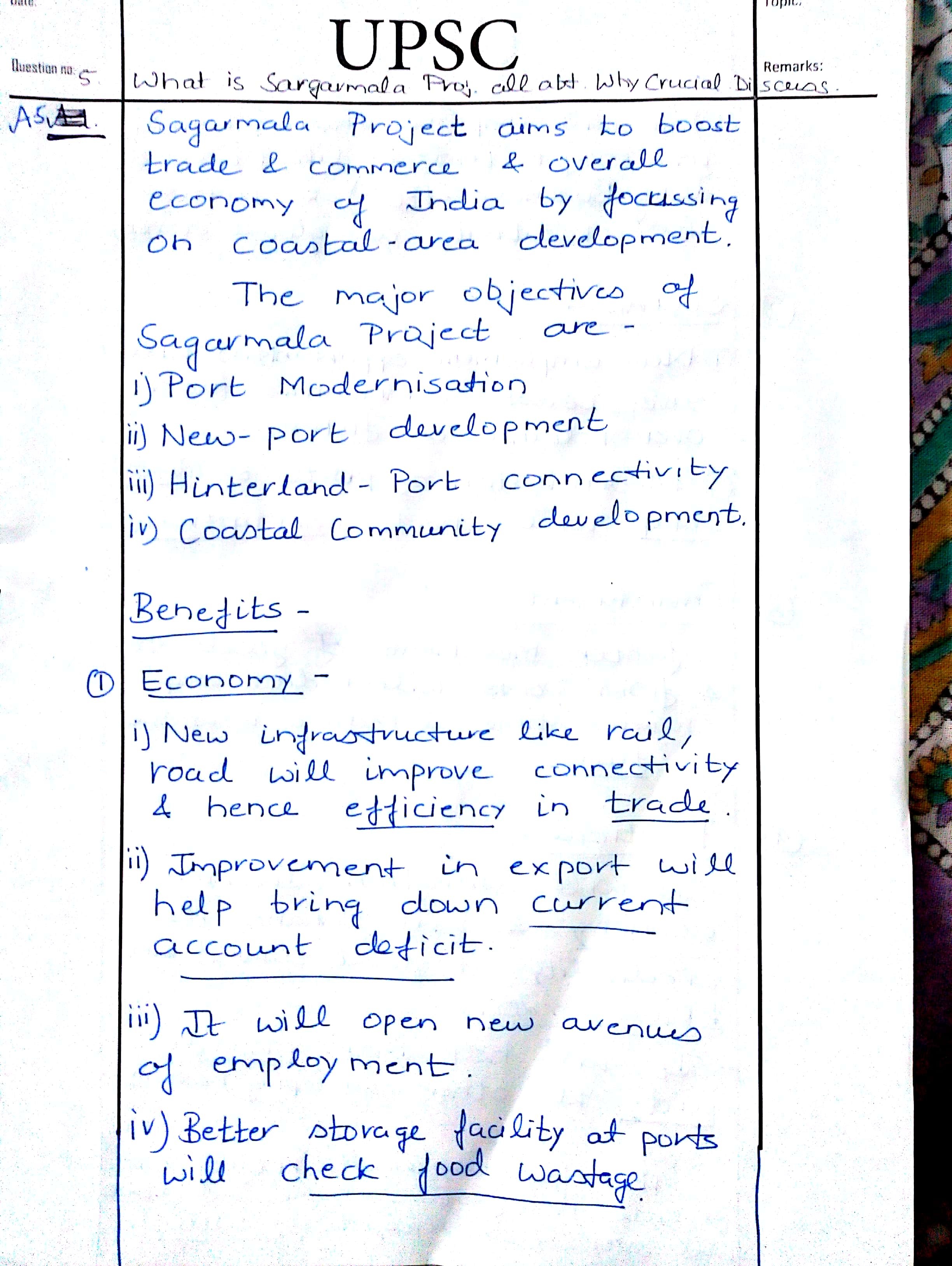
5. What is the Sagarmala project all about? Why is it crucial for India? Discuss.
Introduction:
In order to achieve port led development and develop coastal regions of country, government took up a unique initiative called Sagarmala project. It aims to exploit the Blue economy to achieve high growth and development of country.
Body:
Sagarmala project is about:
- Promote port-led direct and indirect development.
- To provide infrastructure to transport goods to and from ports quickly, efficiently and cost-effectively.
- Enhanced connectivity with main economic centers.
Importance for India:
- Blue economy: To exploit ocean resources for growth.
- Coastal security: It also enhances coastal security along with economic development.
- Port development and modernization: New port infrastructure like better handling capacity, modernization etc.
- Infrastructure: development new infrastructure like new ports, road connectivity to ports etc.
- Inter-connectivity: It leads to inter-connection between roadways, railways, water ways and airways.
- Employment: Provides employment opportunity to coastal area people and increase their standard of living.
- Development: Will help in development of regions around ports by increase in investment, new sectors presence like manufacturing, services etc.
- Efficiency: Will reduce in cost of transportation and make India a new transit hub.
Conclusion:
With this, India’s presence in the region will increase and it will play more roles in piracy threats in India Ocean. This will lead to development of many other minor ports and increase the inflow of foreign capital which helps in growth and development of country.
Best Answer: Abd


