TLP-UPSC Mains Answer Writing

SYNOPSIS: IASbaba’s TLP – 2018: UPSC Mains General Studies Questions [22nd November 2017]- Day 3
1. What are local winds? How do they originate? How do they affect the local weather conditions of a region? Explain.
Approach:
This is a pretty straight forward question where you just need to answer the factual questions. Now if you start explaining everything or every type of local wind, it will be too incomprehensible for you to write and also to complete the answer in world limit. So it’s better that you categorize the winds broadly first and then explain shortly.
In the synopsis we have tried to cover almost all types of prominent winds of the world for your information. In the exam you don’t need to mention them.
Local winds:
There are several winds which develop in response of the local terrain. They are generated through temporary creation of regions with relative high and low pressure. They are known as the local winds. They have a significant impact in the weather conditions of a place and psychology of the society. Broadly they can be catagorised on the basis of periodicity. There can be periodic winds and non periodic winds.
Important periodic winds are – Mountain/Valley winds, Land/sea breeze and monsoons.
Important non periodic winds are – Gravity winds, Chinook, loo etc.
Some of the prominent local winds are:
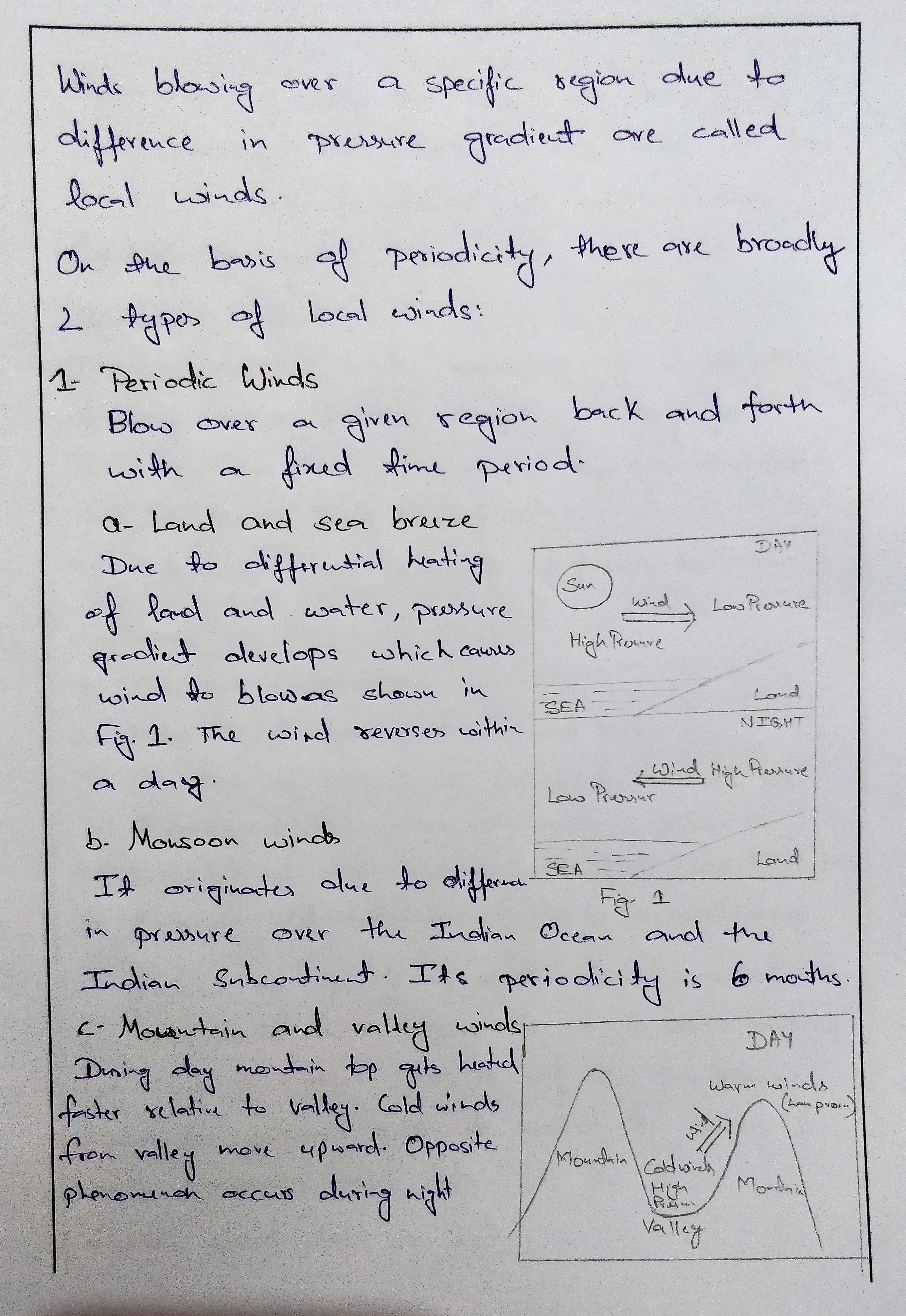
Land and sea breeze: these winds develop as a consequence of the differential heating of the land and sea surfaces. During the day, the land heats up faster and become warmer than the water off shore. Because of this a low pressure area is created over the land surface and relatively high pressure area on sea surface. This causes wind to blow from sea towards the land. This is called sea breeze. On contrary during night, the land loses its heat relatively faster than the sea, hence a breeze starts flowing from land towards the sea surface. This is called land breeze.
These winds are periodic winds and regulate the temperature in coastal areas. The sea breeze has a soothing effect on the weather and increases the efficiency of the people. These winds are more pronounced in tropical and sub-tropical latitudes as differential heating is more here.
Mountain and valley breeze: The mountain and valley breeze also has direction reversal in every 12 hours like land and sea breeze. Mountain air cools rapidly at night and valley air heats up rapidly during day. Thus warm air raises upslope during the day and at night, the cooler air subsides down slope into the valley.
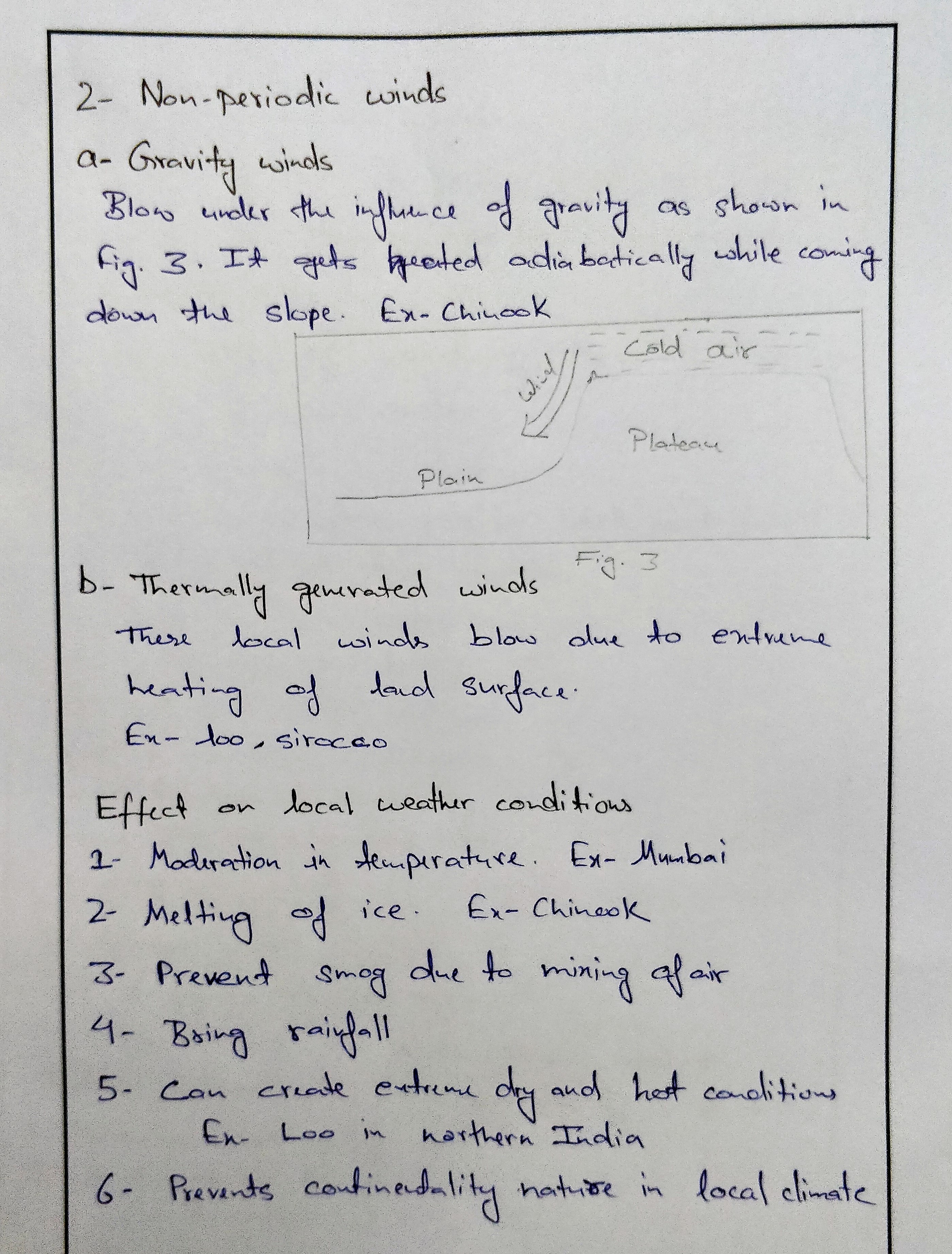
Katabatic winds or stroph( gravity drainage winds) : They are significant on a large scale than mountain and valley winds under certain conditions. These winds are usually stronger than mountain or valley winds. For these winds to blow, an elevated plateau or highland is essential, where layers at the surface cool, become denser and flow down slope. The ferocious winds that can blow off the ice sheets of Antarctica and Greenland are Katabatic in nature.
Some of the local winds, their region of occurrence and characteristics are given blow:
- Blizzard: It is intensely cold fast blowing wind accompanied by snow.blows in north America.
- Bora (Adriatic sea): it descends from mountains during the winter season. It blows with a speed of 120-150km/h. its duration may be from three to five days.
- Brickfielder: it blows from the desert of Australia during the summer season( December to February)
- Buran: it blows in central Asia and Siberia. It is a strong cold north easterly wind which reduces the temperature up to -30o
- Chili: it is a hot dry wind which blows from the Sahara Desert towards the Mediterranean sea through Tunisia.
- Gibli: it blows from the Sahara Desert towards Mediterranean sea through Libya. It is an extreamely hot local wind.it blows during the summer season. It may last for 3-5 days. This wind has extreme effects. Due to heat the government declares the holiday. Because of this the shade temperature reaches up to 60o sometimes the tyres of the car melt and stick to the road. Even the dry grass catches fire. People shelter themselves in the basements.
- Haboob: it is a similar hot wind blowing towards the Mediterranean through Sudan.
- Karaburn: it blows from march to may and leads to hazy weather. It is also responsible for deposition of loess in Huwang Ho valley.
- Khamsin: hot wind blows in Egypt for about 50 days.
- Loo: it blows in summer season in India in northern plains. It is a hot dry wind and raises the temperature. Loo follows a three day cycle. It starts blowing at 9am in the morning till 5 in evening. On its third day, it is accompanied by a storm in the evening called Aandhi and causes little shower taking the temperature down.
- Mistra: it blows in Rhone valley of france. It a cold wind blowing during winters. It has adverse effects on orchards.
- Pampero: cold and dry wind blowing during winter season in Pampas (Argentina).
- Samoon: Hot wind blowing during summers in Iran.
- Simoon: Hot wind blowing during summers in Saudi Arabia.
- Sirroco: hot and humid wind blowing from Sahara to Sicily during April to July.
- Berg: it descends from the Alps in Germany . It helps in melting of snow during winter season.
- Chinook ( snow or ice eater): it blows in USA and Canada between December and march. It descends on the leeward side of the mountain. It is warm and dry and causes the snow to melt. It has a soothing effect on weather and society.
Note:
- In the above synopsis, the weather associated with the winds have been covered with the wind itself. In the form of an answer, you will have to mention that separately as it is asked separately in the question.
- Monsoon as a local wind we have not covered here, as one synopsis is dedicated to monsoon climate.
Best Answer 1: Amber glass
Q.2 Discuss the principles of plate tectonics? Examine the interrelation between plate tectonics and the evolution of the Alps mountain range.
Background:
Plate tectonics defines the movements and features of the Earth’s surface now and in the past. The theory of plate tectonics was advanced in the 1960s and 1970s to generate new information about the Earth’s ancient magnetism, the nature of the ocean floor, the flow of heat from the Earth’s interior, and earthquake and volcanic distribution with the main aim of explaining how the earth works.
Approach:
Mention the principles of plate tectonics and then different types of tectonic boundaries, from it you can interrelate between plate tectonics and the evolution of alps mountain ranges with appropriate diagrams.
Introduction:
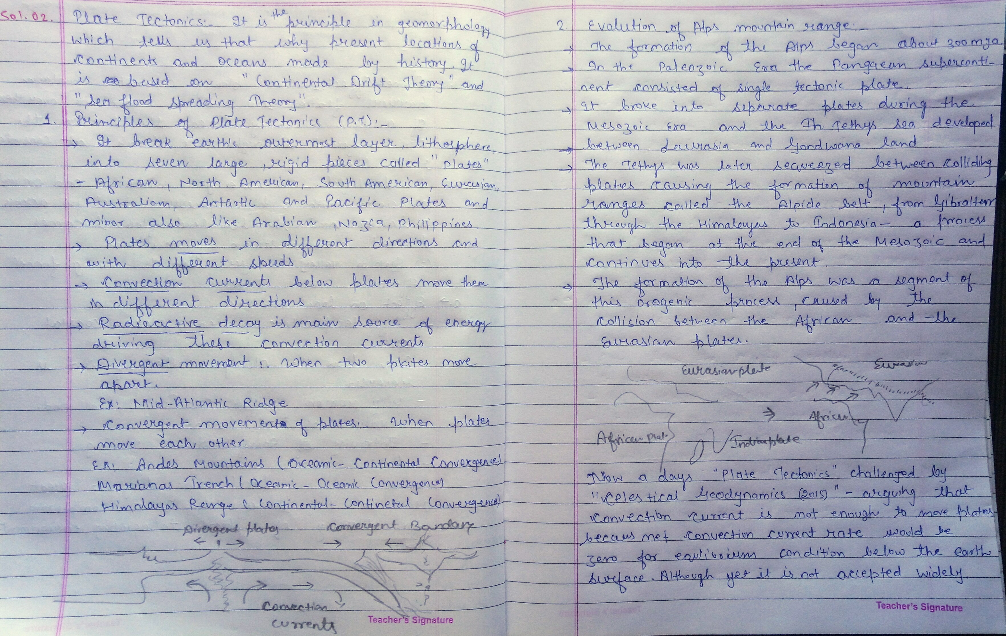
Plate tectonics is a scientific theory describing the large-scale motion of Earth’s lithosphere. There are various basic principles underlying the theory of plate tectonics. The fundamental principles include:
- The plates: This is the principle stating that the Earth’s outer shell is composed of several different hard and rigid plates;
- The Wilson cycle: The Wilson cycle illustrates the lifecycles of oceans and continents. Particularly, it pertains to the rifting, drifting, and colliding of large continental plates to form a small ocean;
- Convection: Convection is the principle defining the movement of the plates. This means, the movement of the plates are influenced by convection currents flowing in the heated, plastic asthenosphere layer below the plates;
- The lithosphere and the asthenosphere: This constitutes the earth’s outermost layer, the crust and the upper mantle. The asthenosphere plate is mostly plastic like fluid due to its nature of high viscosity and mechanical weakness.; and
- The plate tectonic boundaries: Define the regions where the plates meet. The plate tectonic boundaries are usually associated with geological activities like volcanoes, earthquakes, and mountains as well as oceanic physical features.
There are broadly 3 types of plate tectonic boundaries namely:
- Divergent Boundaries: It takes place when the plates move away in opposite directions. Along the boundaries, it is common to find geysers spurting superheated water or lava spews. The process widens the giant basins and renews the ocean floor. Occurrences such as earthquakes and volcanic activities are frequent along the divergent boundaries. E.g. The Great Rift Valley in Africa
- Convergent Boundaries: Formed when the two plates collide ends up forming a rugged mountain range and at times the edge of one or both plates bend the other down into a deep seafloor trench. E.g. the Mariana Trench and formation of Alps.
- Transform Boundaries: Formed due the effects of the plates sideswiping or sliding past each other. During the occurrence of divergent boundaries, artificial and natural structures within the edges of the plates are torn into pieces and carried in opposite directions. E.g. San Andreas Fault in California.
Evolution of Alps mountain ranges:
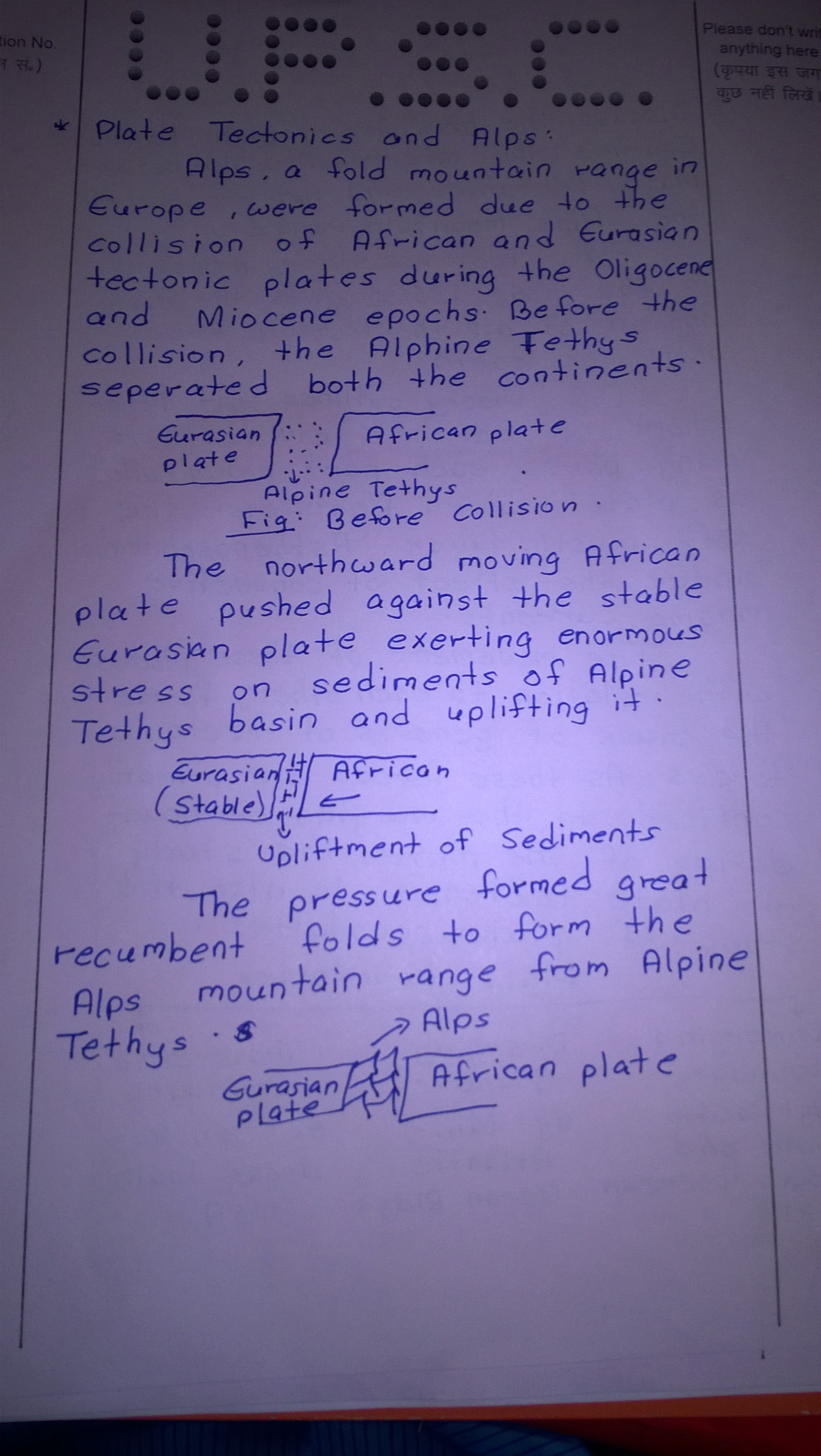
The Alps arose as a result of the collision of the African and Eurasian tectonic plates through the convergent boundary, in which the Alpine Tethys, which was formerly in between these continents, disappeared. Enormous stress was exerted on sediments of the Alpine Tethys basin and its Mesozoic and early Cenozoic strata were pushed against the stable Eurasian landmass by the northward-moving African landmass. Most of this occurred during the Oligocene and Miocene epochs. The pressure formed great recumbent folds, or nappes, that rose out of what had become the Alpine Tethys and pushed northward, often breaking and sliding one over the other to form gigantic thrust faults.
Connection dots:
Please focus on plate tectonics principles and not on plate tectonics, then mention types of plate tectonics boundaries and please explain from it how Alps mountains has formed geologically. Diagrammatic representation is must in geography questions.
Best answer: strider https://uploads.disquscdn.com/images/651384dd642467b3e268500e50184055b8569892f9c5a89b0018abb9958ea857.jpg
Best answer: Mr.√H!π√H∆ ??? https://uploads.disquscdn.com/images/962c199b196fcfe8c9794c91b5d717fc96cdc3c3e5ba9e7e6e9c88c4ba9492fc.jpg
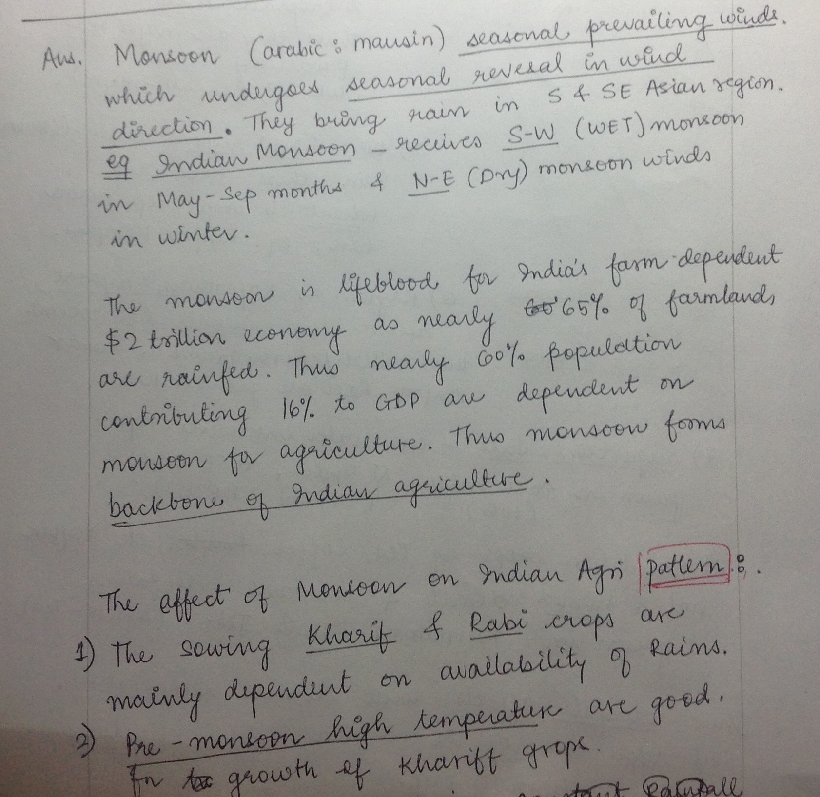
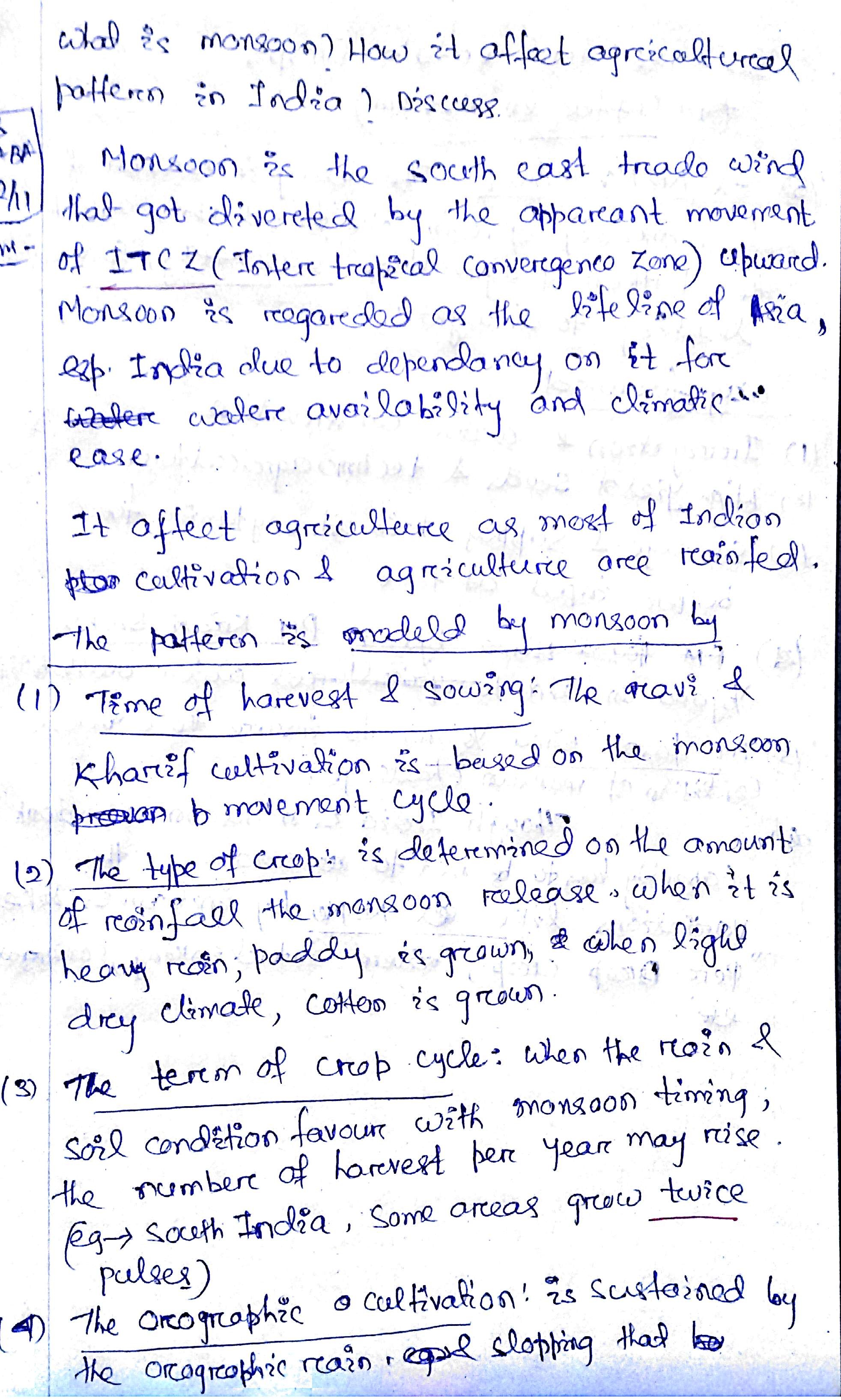
Q.3 What is Monsoon? How does it affect agricultural pattern in India? Discuss.
Approach:
The answer must contain following parts-
- What is monsoon? – It needs to be explained in little detail, rather than just mentioning it is reversal of wind.
- Effect of monsoon on agricultural pattern- This has to be explained temporally (kharif, rabi, zaid seasons) and spatially (rainfall varies from one region to another during monsoon season and so does cropping pattern especially crop choice).
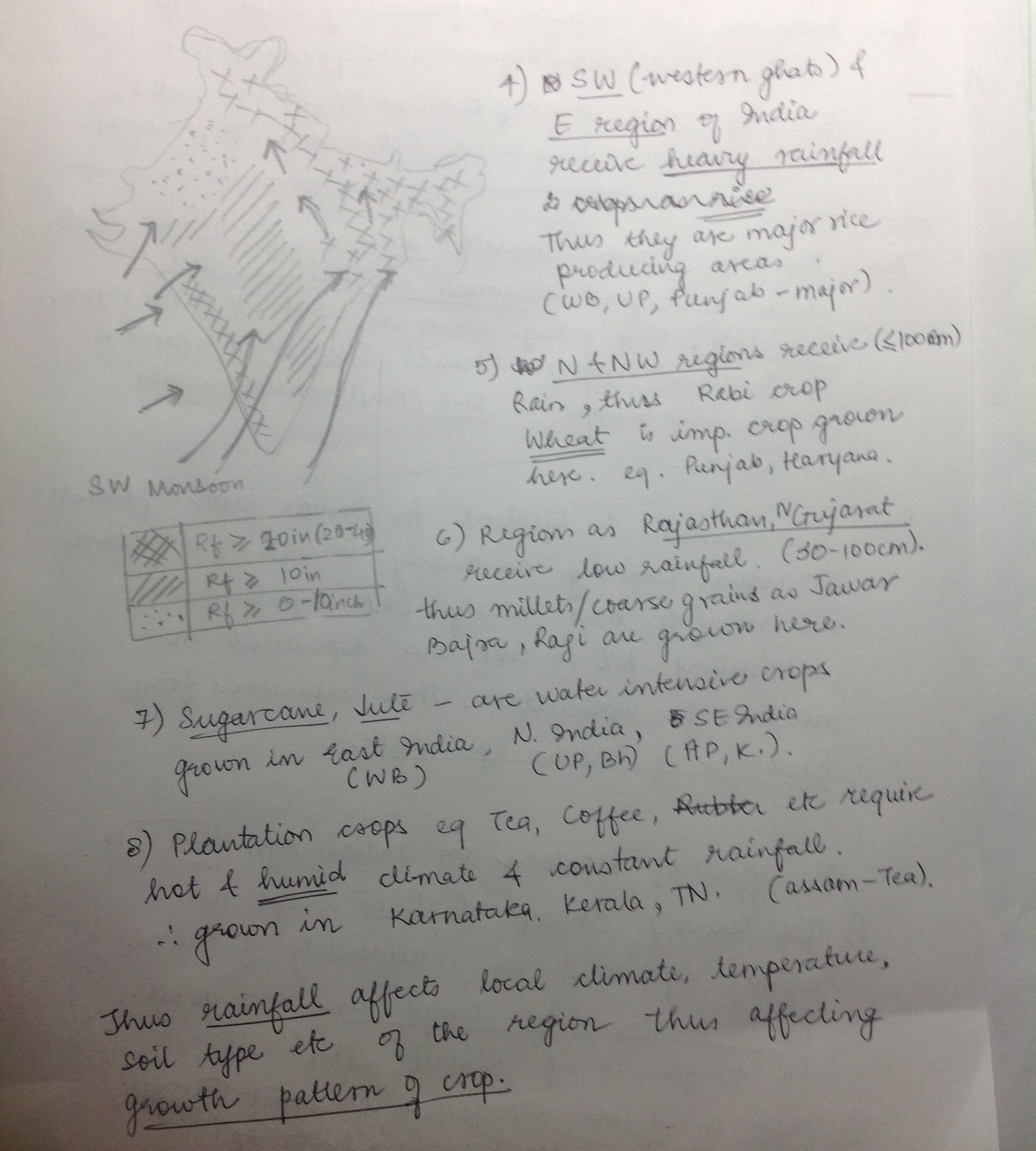
- Diagrams are necessary. Relevant one includes- 1) Images of monsoon wind formation or mechanism, 2) Cropping pattern- different crops grown in different regions depending upon the amount of rainfall.
- Conclusion- Rather than just saying that monsoon affects agricultural pattern we need to stress on how important it is to change traditional ways of agriculture in the wake of climate change.
Background:
Definition of monsoon:
Monsoon is derived from the Arabic word ‘MAUSIM’, which means seasonal reversal of winds,. Shift of ITCZ toward north in summers and change in direction of south east trade winds once it crosses equator results into southwest monsoon. Once the land gets started cooling up the ITCZ regains its pre-summer position and there is reversal of wind resulting into retreating monsoon.
Effect on agriculture pattern:
- Monsson divides Indian seasons into three agricultural seasons-
Kharif (late summer with heavy rainfall)- crops grown includes rice, cotton.
Rabi (winters with winter rainfall from weaterlies)- crops grown includes wheat, mustard.
Zaid seasons (spring with clear weather, occasional showers)- crops grown includes fruits and vegetables - Early monsoon showers also provide conditions for growth of mangoes in Kerala and cherry blossom in Karnataka.
- More rainfall in watershed region across western ghats and northeast India thus plantation agriculture in states like Kerala, Karnataka and northeastern states.
- Rainfall decreasing from east to west in North India, thus rice which requires 100-150 cm rainfall grown in states like WB and wheat which requires less of rainfall grown in Punjab, Haryana etc.
- Nearly 60% of total net sown area comes under rain fed agriculture, rest being irrigated agriculture.
- Three consecutive crops in areas of high rainfall. West Bengal sees three rice growing seasons- Aus, Aman and Boro.
- Around 70% of the agriculture is rainfed, that is it totally depends on the monsoon rains.
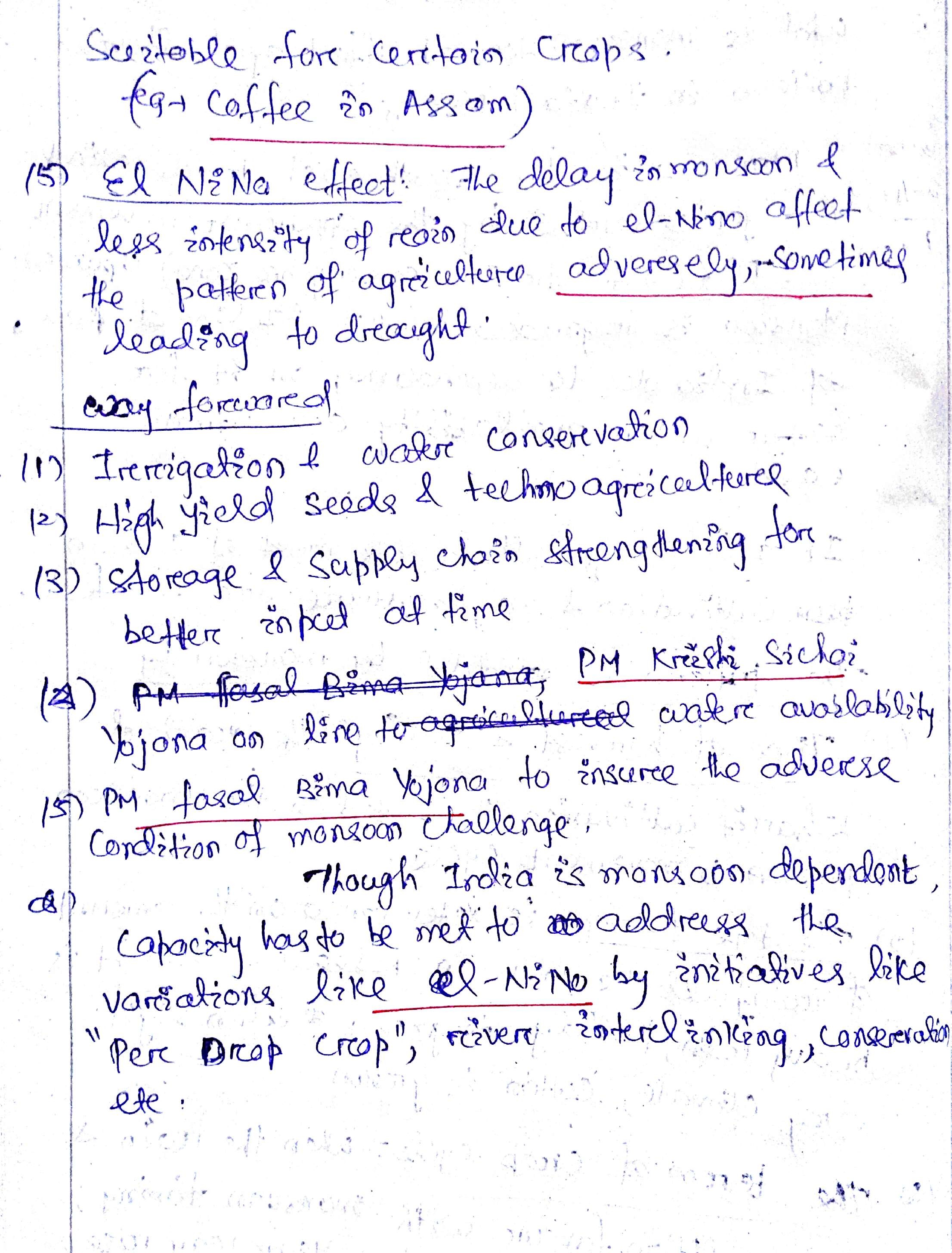
Conclusion:
Ongoing climate change has increased the unpredictability of monsoon rains resulting into more droughts as well as floods across the country. In this light the right step should be to make agriculture monsoon-proof. In this light, schemes like Pradhan Mantri Krishi Sinchai Yojana which seeks to bring more agricultural area into irrigation must be implemented effectively. Further international efforts towards predicting monsoon shoulb be strengthened further so that it becomes more predictable.
Connecting the dots:
- Question is about effect of monsoon on agricultural pattern and not agriculture. This should not be missed. Answer should thus stress on describing how pattern varies from time to time and place to place because of monsoons.
- Another question which can be asked in how changing pattern of monsoon is affecting agricultural pattern.
Best answer 1: Invincible
Best answer 2: Lone fighter
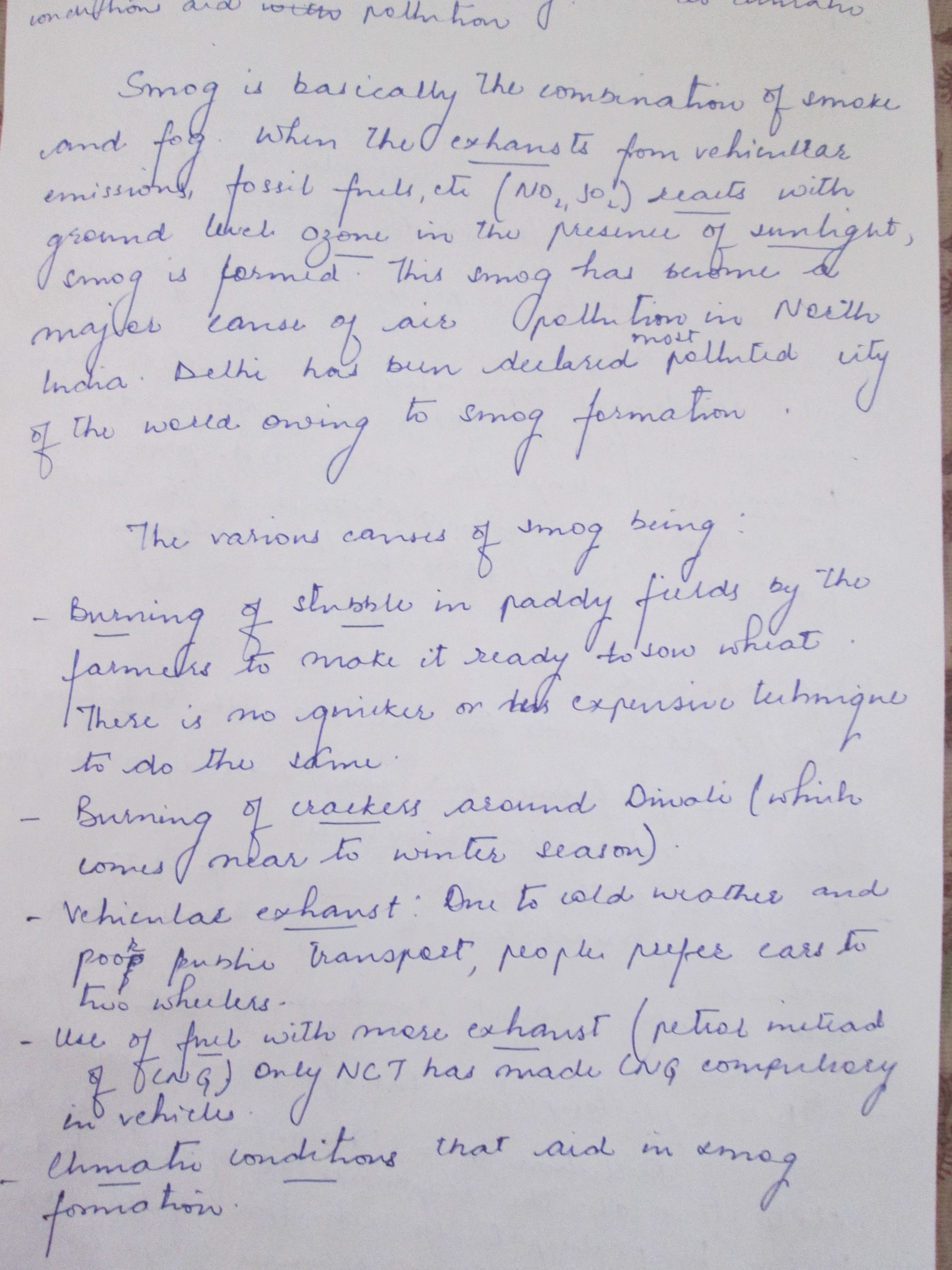
4. North India gets covered by a blanket of smog every year during winters. Why? How do climatic conditions aid pollution? Discuss with the help of suitable examples.
Background: The government is constantly issuing health advisory after parts of North India, including the National Capital Region, came under the grip of a dense smog because of poor air quality.
Approach: This question test Students ability to understand issues of wider concerns and come out with important causes and contributors for such phenomenon. Smog being a recurring phenomenon requires deeper understanding not only from environmental but geographical perspective as well.
Here one should start with defining smog, as this is the primary theme around which whole issues resolve. You need to come out with anthropogenic (manmade) as well as natural factors. You should try to draw diagram for better clarity and impactful presentation in such questions.
Here climatic conditions aiding pollution should connect to theme provided in first part of the question. No need to write general points, better stick to the smog phenomenon and factors aiding smog formation .You should come out with simple and relevant examples.
Conclusion should be suggestive, providing measures to tackle this recurring issue
Introduction:
Every year during winter’s north India gets covered by smog which results in loss of life and property. Smog is result of smoke and fog which diminishes visibility and reduces air quality. The causes for this are many and interlinked to each other.
Body:
The present condition prevailing in north India can be attributed to following reasons:
Weather conditions: During winter North India witnesses calm and cool weather conditions with very little wind speed or no wind at all, along with low temperatures. This results in suspension of emissions from vehicles containing heavier particulate matter in the lower layers of atmosphere and is unable to escape upwards or move away due to low speed of wind that may drive it away.
Stubble burning: The possible inflow of emissions from agriculture residues burning in nearby states like Punjab, Haryana and Uttar Pradesh is decided by the wind patterns. With the direction of winds (from these states) towards Delhi and an increase in its speed, the smog build-up aggravates.
Cyclonic pattern: Further, the cyclonic pattern of Nilofar may have induced a change in the flow and direction of the wind towards Northern states, especially Delhi.
The climatic conditions also play part in aiding the pollution
Wind speed: Wind carries air contaminants away from their source, causing them to disperse. In general, the higher the wind speed, the more contaminants are dispersed and the lower their concentration. However, high wind can also generate dust – a problem in dry windy rural areas.
Atmospheric turbulence/stability: As the ground heats during the day the air becomes more turbulent which causes polluted air to disperse as it moves away from its source. In contrast, under stable air conditions at night when the air is cooler, air contaminants released in urban areas such as from home fires, are not easily dispersed causing localised air pollution.
Inversion layers: Inversions are important because the upper warmer layer acts like a lid which traps air contaminants underneath. They are usually dispersed by wind or by warm air rising as the ground heats up. But if the inversion layer stays in place for a long time pollutants can build up to high levels.
Sunshine: It makes some pollutants undergo chemical reactions, producing smog.
Conclusion: Smog causes a lot of health, environment and economic problems. It is required that alternative is provided to farmers for machinery clearing of their fields rather than burning them. Graded response to pollution, SAFAR app for real-time pollution levels etc are right steps. Right to clean environment is a part of Art 21.Environment is an essential condition for coming good in health indicators; It thus, becomes imperative to address the issue immediately.
Connecting the dots: This topic can be asked from geographical, environmental, medical or health related angles. One can also be asked why north India chokes on bad air as south breathes easy. You should be able to answer all these possible aspects.
Best Answer: Nazia
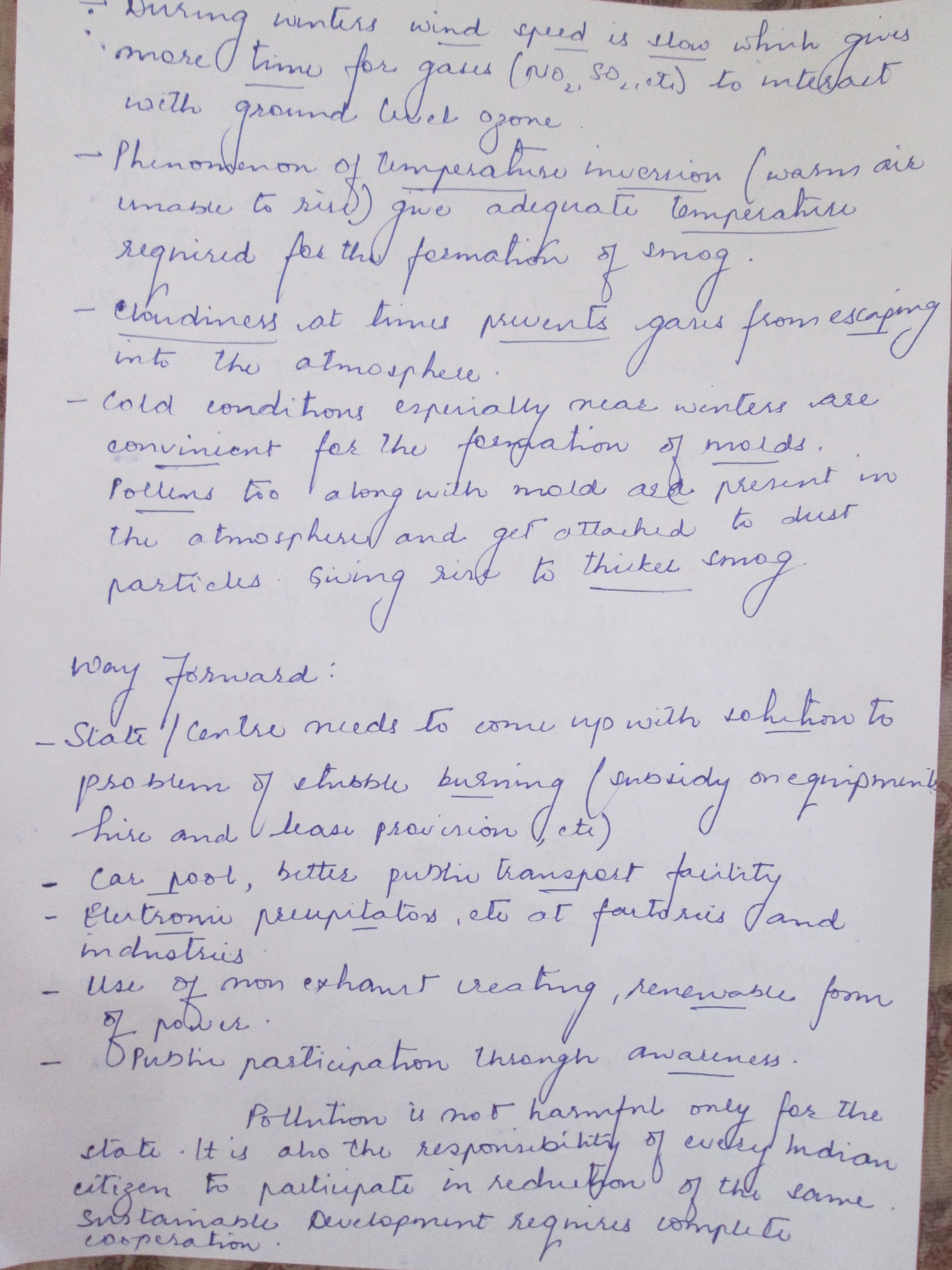
Q.5) The months of July and August witnessed catastrophic floods in North India. Many states got severely affected by it. What causes frequent floods in India? Can river interlinking address this problem? Examine.
Approach:
Since it is easy question and most of the people will have very similar content. Try to categorize and write. Two parts, one is causes and the other Interlinking. First part divide into Natural and Anthropogenic. 2nd part divide into advantages and disadvantages.
Background:
The 2017 monsoon resulted in flooding in several north indian states like Gujarat, Assam, Arunachal Pradesh, Bihar and parts of West Bengal, Uttarakhand, Jammu & Kashmir and Uttar Pradesh.
These areas coincide with actual flood prone areas of India, which stands at total 40 million hectare out of 329 mha of total land area. As Identified by Government of India, chronic flood prone areas include the Indo-gangetic plains , the Brahmaputra plains, Gujarat, Maharashtra, Odisha, Seemandhra and Telangana.
Body:
Points to be covered:
Several factors cause floods in India:
- Natural factors:
- Meteorological- Heavy rainfall, storm surge, tsunami, cloud burst
- Geomorphic- Glacial lake outburst flooding (GLOF), landslides, seismic activity, large catchment area of river, poor drainage, low gradient of river course
- Anthropogenic factors:
Deforestation, Encroachment for agriculture, shifting cultivation, unscientific rotation of crops, bursting of dams and embankments, urbanization, excess water release from dams during heavy rainfall
Factors that make their occurrence frequent:
Climate change, unscientific urban planning (use of storm channels, watershed encroachment) and increasing human interference.
River interlinking:
It is an ambitious project of central government to link surplus river basin with deficient river basin to solve surplus and shortage problems of various regions of the country.
YES:
- Water from surplus to deficit basins (ken to Betwa).
- Reduce excess water which results in flooding . Especially regions like Bihar, UP etc.
- Also helps in keeping flow yearlong useful for water transportation and year round agriculture.
No:
- If water stored: Big dams brought avoidable flood disasters eg. Damodar, Farakka; Problem in water storage in flood prone regions(N-E India terrain, high density in N India)
- If water transferred: Flooding occurs at same time across rivers(Brahmaputra, Mahanadi, godavari etc)
Conclusion:
River interlinking has two sides, where at one side it does solve the problem to some extent but at other end it creates new problems and also it needs enormous funds and diversion of pristine forest areas as many rivers flow through them. If advantages outweigh disadvantages then it can be a transformation in the country.
Connecting the dots:
- Urban flooding
- Flood mitigation
- Disaster planning
- Climate change and coastal inundation
Best Answer: disha


