UPSC Articles

High Speed Rail work gathers momentum for Delhi – Varanasi High Speed Rail Corridor with the start of LiDAR (Aerial Ground) Survey
Part of: GS Prelims and GS-III – Economy; Sci & Tech
In news
- With the start of LiDAR (Aerial Ground) Survey, High Speed Rail work gathered momentum for Delhi – Varanasi High Speed Rail Corridor.
Key takeaways
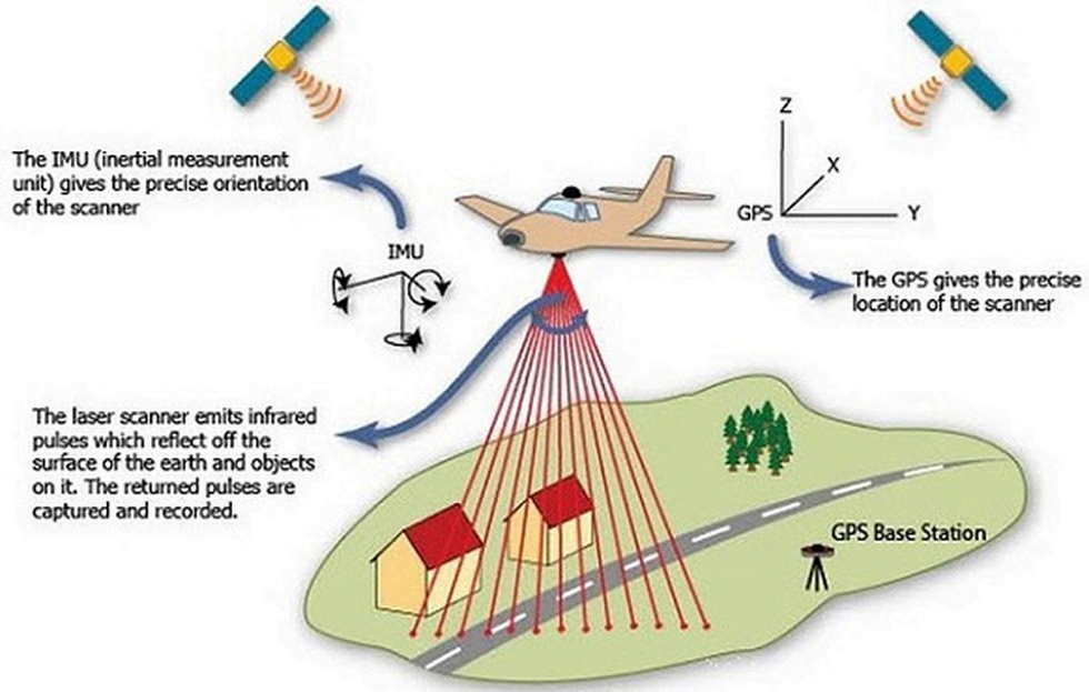
- The LiDAR survey for Delhi-Varanasi High Speed Rail Corridor started from Greater NOIDA where a Helicopter fitted with state of art Aerial LiDAR and Imagery sensors took the first flight and captured the data related to ground survey.
- National High Speed Rail Corporation Limited is adopting Light Detection and Ranging Survey (LiDAR) technology which provides all the ground details and data in 3-4 months wherein this process normally takes 10-12 months.
- The ground survey is a crucial activity for any linear infrastructure project as the survey provides accurate details of areas around the alignment.
Important value additions
LiDAR
- Lidar, which stands for Light Detection and Ranging, is a remote sensing method that uses light in the form of a pulsed laser to measure ranges (variable distances) to the Earth.
- These light pulses—combined with other data recorded by the airborne system— generate precise, three-dimensional information about the shape of the Earth and its surface characteristics.
- A LiDAR instrument principally consists of a laser, a scanner, and a specialized GPS receiver.
- This technology is mostly used for ground-based surveys.
- LiDAR was first used on a spacecraft during the Apollo 15 mission in 1971, when astronauts mapped the surface of the moon.
- Apart from aerial surveys, the LiDAR sensor is the most important component in self-driving cars. The LiDAR sensor provides continuous 360 degrees of visibility and accurate depth information.
Do you know?
- Airplanes and helicopters are the most commonly used platforms for acquiring the data.
- It can be used to examine both natural and manmade environments with accuracy, precision, and flexibility.
- Two types of LiDAR are:
- Topographic typically uses a near-infrared laser to map the land
- Bathymetric uses water-penetrating green light to measure seafloor and riverbed elevations.
Related articles:
- About LiDAR: Click here
- Prehistoric settlements discovered through Light Detection and Ranging (LiDAR) data: Click here