Economics

Syllabus
- GS-3: Disaster Management
- GS-3: Indian Economy & Development
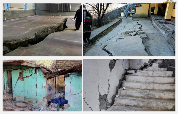
Context: Wide cracks have appeared in many roads and hundreds of houses in Joshimath, Uttarakhand, and the authorities have declared it a landslide and subsidence-hit zone.
- Families were evacuated to temporary relief centres for their own safety.
- The signs of sinking first appeared in October 2021 and subsequently cracks continued to appear around town and residents resorted to repairs.
- It is also worth noting that the Indian Space Research Organisation (ISRO) said in a report that the town in Uttarakhand sank 5.4 cm between December 27, 2022, and January 8, 2023. However, the report and the satellite images were later withdrawn from the ISRO website.
What are India’s seismic zone maps ?
A published in the Journal of theInternational Society for the Prevention and Mitigation of Natural Hazards said that almost 65% of India falls in high to very high seismic zones.
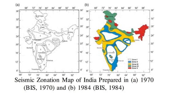
- According to the 2002 version of India’s seismic zone map, earthquake-prone regions in the country are divided into four zones – zone II, III, IV, and V – based on intensity levels during past earthquakes. However, this is not the version of the map that has always been in use.
- The first national seismic zoning map of India was compiled by the Geological Survey of India in 1935, after the 1934 Nepal-India earthquake that measured over 8.0 on the Richter scale and destroyed Kathmandu, Bhaktapur and Patan in Nepal.
- It consisted of three zones – severe, light, and minor hazard, “based on the broad concept of space-time earthquake statistics and the prevailing understanding of geotectonic” movements
- In 1962, the Bureau of Indian Standards (BIS) published a seismic zonation map of India.
- This map marked earthquake epicentres in the country and built on the isoseismic map published by the GSI in 1935.
- It divided India into seven zones – from 0 (no damage) to VI (extensive damage).
- It was reviewed in 1966, using geological and tectonic features to modify the zones.
- Until 1967, seismologists were under the impression that most of the Deccan plateau and peninsular India were free from seismic activity. However, in 1967, a 6.3-magnitude earthquake struck the Koyna hydroelectric project killing hundreds of people and injuring thousands. This led to major revisions in the 1970 seismic zone map of India.
- The 1970 map consisted of five zones – I, II, III, IV, and V – based on the Modified Mercalli Intensity (MMI) scale with a Comprehensive Intensity Scale (CIS-64).
- The MMI scale takes into account the effect of earthquakes on people, objects, and buildings, and estimates the shaking intensity from an earthquake at a specific location.
- Zero was removed as a zone since it was deemed scientifically inappropriate to consider a region completely safe from earthquakes.
- Another major change in the 1970 version of the map was the merging of zones V and VI.
- A new update to India’s seismic zone map was released in 1984. This map identified the seismic potential of regions based on past earthquakes as well as its tectonic features.
- Seismic zone maps after 1984
- Till 1984, IS 1893 was the main seismic code of India, and all seismic zone maps were based on it. This code was revised in 1966, 1970, 1975, and 1984. In 1991, it was decided that IS 1893 would be split into parts.
- Latur in Maharashtra was struck by an earthquake of intensity IX (on MMI-CIS-64 scales) in 1993. The 3-magnitude earthquake killed thousands of people and occurred in a region that was placed in zone I — an area at low risk. This led to further revisions in the seismic zonation map of India.
What do India’s seismic zones signify?
- Seismic zones signify the intensity of earthquakes which are most likely in those classified areas.
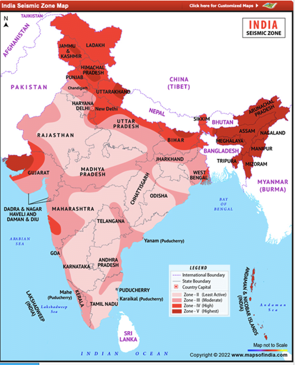
- The latest seismic zone map of India was released in 2002 with only four zones – II, III, IV, and V.
- Color coded in different shades of the color red, this map shows the four distinct seismic zones of India. Following are the varied seismic zones of the nation, which are prominently shown in the map:
- Zone – II: This is said to be the least active seismic zone.
- Zone – III: It is included in the moderate seismic zone.
- Zone – IV: This is considered to be the high seismic zone. Zone IV includes areas prone to earthquakes of severe intensity, and include Patna, Pilibhit, Ludhiana, Roorkee, Gorakhpur, and Amritsar.
- Zone – V: It is the highest seismic zone. The entire northeast India, parts of northwestern Bihar, Kangra Valley in Himachal Pradesh, Andaman and Nicobar Islands, eastern part of Uttarakhand, Rann of Kutch in Gujarat, and Srinagar area in Jammu and Kashmir were all placed in zone V
- Approximately 11% area of the country falls in zone V, 18% in zone IV, 30% in zone III and the remaining in zone II.
- An Indian seismic zoning map assists one in identifying the lowest, moderate as well as highest hazardous or earthquake prone areas in India.
- Even such maps are looked into before constructing any high rise building so as to check the level of seismology in any particular area
Main Practice Question: Why are we frequently witnessing disasters in Chamoli district of Uttarakhand? What measures can be adopted to mitigate it?
Note: Write answer his question in the comment section.


