IASbaba's Daily Current Affairs Analysis

Archives
(PRELIMS & MAINS Focus)
Syllabus
- Prelims & Mains – Economy
Context: Smartphone PLI (production-linked incentive), the most successful of all 14 such schemes, may be extended by a couple of years beyond 2025-26 when it officially ends.
Background:-
- The scheme aimed to attract significant foreign investment in the sector while encouraging domestic mobile phone makers to expand their units and presence in India.
Key takeaways
- The Production Linked Incentive (PLI) Scheme is an initiative by the Government of India to boost domestic manufacturing and reduce imports.
- The scheme provides companies with incentives on incremental sales from products manufactured in domestic units.
Here are some key details about the PLI Scheme:
- The scheme was announced with an outlay of INR 1.97 Lakh Crores across 14 key sectors to create national manufacturing champions, create 60 lakh new jobs, and an additional production of 30 lakh crore during the next 5 years.
- It aims to attract foreign companies to set up units in India while encouraging local companies to expand their manufacturing units.
- The scheme targets labor-intensive sectors in the hope to create new jobs for the ballooning employable workforce of India.
- The 14 sectors are: (i) Mobile Manufacturing and Specified Electronic Components, (ii) Critical Key Starting Materials/Drug Intermediaries & Active Pharmaceutical Ingredients, (iii) Manufacturing of Medical Devices (iv) Automobiles and Auto Components, (v) Pharmaceuticals Drugs, (vi) Specialty Steel, (vii) Telecom & Networking Products, (viii) Electronic/Technology Products, (ix) White Goods (ACs and LEDs), (x) Food Products, (xi) Textile Products: MMF segment and technical textiles, (xii) High efficiency solar PV modules, (xiii) Advanced Chemistry Cell (ACC) Battery, and (xiv) Drones and Drone Components.
- PLI Schemes for all 14 Sectors have been notified by the concerned Ministries/ Departments after due approval. These Schemes are in various stages of implementation by the implementing Ministries/ Departments.
- The PLI scheme is expected to have a cascading effect on the country’s MSME ecosystem.
- All the approved sectors identified under PLI Schemes follow the broad criteria of focusing on key technologies where India can leapfrog and multiply employment, exports and overall economic benefits for the economy.
Additional Information:
- The smartphone PLI has seen domestic production of phones rising to Rs 4.1 trillion in FY24 from Rs 2.14 trillion in FY20, the year before the scheme was announced. Smartphones exports from the country rose to Rs 1.2 trillion in FY24, compared to Rs 27,225 crore in FY20.
Source: Financial Express
Syllabus
- Prelims – GEOGRAPHY
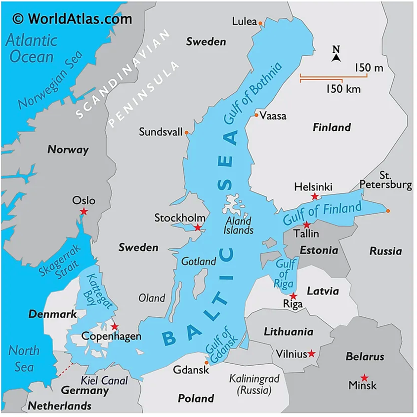
Context: A Russian defence ministry proposal to revise Russia’s maritime border in the eastern Baltic Sea was deleted on Wednesday from an official portal after creating confusion and concern among NATO members such as Finland, Sweden, Lithuania and Estonia.
Background:
- Finland and the Baltic states are all members of the EU and Nato and the military alliance is committed to defending their borders.
About Baltic Sea
- Baltic Sea, arm of the North Atlantic Ocean, extending northward from the latitude of southern Denmark almost to the Arctic Circle and separating the Scandinavian Peninsula from the rest of continental Europe.
- The Baltic Sea is enclosed by Denmark, Estonia, Finland, Germany, Latvia, Lithuania, Poland, Russia, Sweden, and the North and Central European Plain.
- It is a shelf sea and marginal sea of the Atlantic with limited water exchange between the two, making it an inland sea.
- The Baltic Sea drains through the Danish Straits into the Kattegat by way of the Øresund, Great Belt and Little Belt. It includes the Gulf of Bothnia (divided into the Bothnian Bay and the Bothnian Sea), the Gulf of Finland, the Gulf of Riga and the Bay of Gdańsk.
Additional information
- The Baltic states or the Baltic countries is a geopolitical term encompassing Estonia, Latvia, and Lithuania.
- All three countries are members of NATO, the European Union, the Eurozone, and the OECD. The three sovereign states on the eastern coast of the Baltic Sea are sometimes referred to as the “Baltic nations”.
Source: Wikipedia
Syllabus
- Prelims & Mains – Environment
Context: About half of the world’s rangelands are degraded and need policy interventions, and communities depending on them need focused support, according to a new report of the United Nations Convention on Combating Desertification (UNCCD).
Background:
- Rangelands cover 80 million sq km, which is 54 per cent of the earth’s land surface. They are characterised by low vegetation and comprise grasslands, shrublands, wetlands, desert, semi-arid land, mountain pastures, plateaus and tundra.
- In India, rangelands occupy about 1.21 million sq km, from the Thar Desert to Himalayan meadows, as per the UNCCD report.
What are rangelands?
- The UNCCD report defines rangelands as natural or semi-natural ecosystems that are grazed by livestock or wild animals. Rangelands contain vegetation such as grasses, shrubs, bushes, open forests, and agroforestry systems (land which contains trees and crops or pastures). The exact nature of rangelands’ vegetation is influenced by rainfall, temperature, and other climate phenomena.
- Currently, rangelands cover 80 million sq km of Earth’s terrestrial surface area (over half of Earth’s land), and are thus the largest land cover or land use type in the world, the UNCCD report said.
- They act as carbon sinks (which absorb more carbon from the atmosphere than they release), storehouses of freshwater, and prevent desertification of land. Millions of people worldwide depend on rangelands for food security, and livelihoods.
- Rangelands generate 16% of global food production and 70% of feed for domesticated herbivores, most significantly in Africa and South America,” the UNCCD report stated.
What does the UNCCD report say?
- The UNCCD report found that nearly 50% of the world’s rangelands can be considered “degraded” and are facing a “silent demise”.
- Climate change, unsustainable land and livestock management practices, biodiversity loss, and the conversion of rangelands to farmlands are some of the primary drivers of rangeland degradation. Uncertainty over land rights among pastoralist communities also leads to their degradation.
- This, in turn, severely affects the communities dependent on rangelands as their deterioration impacts soil fertility and biodiversity, leading to a dip in incomes and rise in conflicts with authorities over grazing rights.
Who are pastoralists?
- Pastoralism is a livelihood system based on livestock production. This includes livestock rearing, dairy production, meat production, wool production, and leather production.
- The communities and groups, both indigenous and non-indigenous, who are involved in livestock production are known as pastoralists. These communities rear sheeps, goats, cattle, horses, donkeys, camels, yaks, llamas, alpacas, and pigs. Some pastoralist communities also rear ducks and chickens.
- Their livelihood is highly dependent on the quality of pasture (or rangelands) they have access to, and their rights over them.
- In India, while there are no official figures, research and advocacy groups peg their population at around 13 million people, across 46 groups including Gujjars, Bakarwals, Rebaris, Raikas, Kurubas, and Maldharis, to name a few.
What are pastoralists’ economic contributions in India?
- India is home to 20% of the world’s livestock population. Around 77% of these animals are reared in pastoralist systems, meaning they are either herded or left to range on common lands, according to the Accounting for pastoralists in India (2020) report.
- Pastoralists also protect indigenous livestock breeds, and protect traditional knowledge about animal rearing.
- Currently, India is the largest producer of milk in the world, accounting for 23% of global dairy production. It is also the largest producer of buffalo meat and largest exporter of sheep and goat meat, according to the Department of Animal Husbandry and Dairying. Pastoralists are a major contributor in this sector.
Source: Indian Express
Syllabus
- Mains – GS 3
Context: The National Green Tribunal (NGT) has ordered the Chennai Metropolitan Development Authority (CMDA) to get approval from the Tamil Nadu State Coastal Zone Management Authority (TNSCZMA) before carrying out any activity on the city’s beaches, besides cleaning and removing encroachments.
Background:
- As part of its ₹100-crore Chennai Shoreline Renourishment and Revitalization Project, the CMDA had planned for ‘integrated coastal community development’ in Kasimedu, Tiruvottiyur, and Injambakkam-Akkarai stretches involving facilities such as a prefab building, cycle track, food court, landscape, open air theatre, open parking, pedestrian walkway, and a play area in Coastal Regulation Zone (CRZ) II areas, where such activities are prohibited.
Key Takeaways
- The Coastal Regulation Zone (CRZ) is a protective zone along India’s coastline, created by the Indian Government for the preservation of the coastal environment and ecosystem.
- The CRZ was first notified under the section 3 of the Environment Protection Act, 1986 of India, in February 1991
COASTAL REGULATION ZONE NOTIFICATION, 2019
- Apart from the conservation and protection of coastal environment, the 2019 notification also leads to enhanced activities in the coastal regions thereby promoting economic growth resulting in employment generation and better standard of living.
Salient features of the Notification of 2019 are as follows –
- CRZ-I : It has been further classified as CRZ-I A, which are environmentally most critical. CRZ-I B comprises of Intertidal zone i.e., area between LTL (Low Tide Line) and HTL (High Tide Line).
- CRZ-II shall constitute the developed land areas up to or close to the shoreline, within the existing municipal limits or in other existing legally designated urban areas, which are substantially built-up.
- Land areas that are relatively undisturbed (viz rural areas etc) and those do not fall under CRZ-II, shall constitute CRZ –III.
- CRZ-III shall be further classified into following categories:
- CRZ-III A: Such densely populated CRZ-III areas, where the population density is more than 2161per sq km as per 2011 census base, shall be designated as CRZ –III A.
- CRZ-III B: All other CRZ-III areas with population density of less than 2161 per sq km, as per 2011 census base, shall be designated as CRZ-III B.
- Extend of No development zone (NDZ) differs in both areas.
- CRZ IV is classified as Water area and further classified as CRZ-IV A and CRZ-IV B
- Clearance procedures for projects or activities located in CRZ-I and CRZ-IV to be dealt with by the Ministry of Environment, Forests & Climate Change. Whereas, powers for clearance under CRZ-II and CRZ-III have been delegated to State level with necessary guidance.
- Boost for the tourism industry as temporary tourism facilities like shacks, toilets, change rooms, drinking water facilities have been permitted in the No Development Zone of CRZ-III areas with a minimum distance of 10m from the HTL.
- Critically Vulnerable Coastal Areas (CVCA): Sundarban region of West Bengal and other ecologically sensitive areas identified as under Environment (Protection) Act, 1986 such as Gulf of Khambat and Gulf of Kutchh in Gujarat, Malvan, Achra-Ratnagiri in Maharashtra, Karwar and Coondapur in Karnataka, Vembanad in Kerala, Gulf of Mannar in Tamil Nadu, Bhaitarkanika in Odisha, Coringa, East Godavari and Krishna in Andhra Pradesh shall be treated as Critical Vulnerable Coastal Areas (CVCA) and managed with the involvement of coastal communities including fisher folk who depend on coastal resources for their sustainable livelihood.
Source: Hindu
Syllabus
- Prelims – Current Event
Context: Spain has become the 99th member of the International Solar Alliance.
Background:
- The International Solar Alliance (ISA) is a collaborative platform for increased deployment of solar energy technologies as a means for bringing energy access, ensuring energy security, and driving energy transition in its member countries.
About INTERNATIONAL SOLAR ALLIANCE (ISA) :
- The ISA was conceived as a joint effort by India and France to mobilize efforts against climate change through deployment of solar energy solutions.
- It was conceptualized on the side-lines of the 21st Conference of Parties (COP21) to the United Nations Framework Convention on Climate Change (UNFCCC) held in Paris in 2015.
- Vision : Let us together make the sun brighter.
- Mission: Every home no matter how far away, will have a light at home
- The Headquarters is in India with its Interim Secretariat being set up in Gurugram.
- With the amendment of its Framework Agreement in 2020, all member states of the United Nations are now eligible to join the ISA.
- The ISA is guided by its ‘Towards 1000’ strategy which aims to mobilise USD 1,000 billion of investments in solar energy solutions by 2030, while delivering energy access to 1,000 million people using clean energy solutions and resulting in installation of 1,000 GW of solar energy capacity.
- This would help mitigate global solar emissions to the tune of 1,000 million tonnes of CO2 every year.
- The International Solar Alliance is headed by the Director General, who leads the operations and carries out the functions of the ISA Secretariat and is responsible to the ISA Assembly.
Important project of ISA:
- One Sun One World One Grid (OSOWOG): The OSOWOG focuses on a framework for facilitating global cooperation, building a global ecosystem of interconnected renewable energy resources (mainly solar energy) that can be seamlessly shared.
Source: newsonair
Syllabus
- Mains – GS 1 & GS 3
Context: The satellite monitoring data by the Indian Space Research Organisation (ISRO) has shown a large expansion in glacial lakes between 1984 and 2023 in the Himalayan region, which has posed an alarming situation for the downstream areas.
Background:
- The glacial lakes are categorised based on their formation process into four broad categories, namely Moraine-dammed (water dammed by moraine), Ice-dammed (water dammed by ice), erosion-dammed (water dammed in depressions formed by erosion), and other glacial lakes.
ISRO’s Observation on Expansion of Himalayan Glacial Lakes:
- Of the 2,431 lakes larger than 10 hectares identified during 2016-17, 676 glacial lakes have notably expanded since 1984. 130 of these lakes are situated within India, with 65, 7, and 58 lakes located in the Indus, Ganga, and Brahmaputra River basins, respectively.
- Long-term changes in the Ghepang Ghat glacial lake (Indus River Basin) at an elevation of 4,068 m in Himachal Pradesh, India, show a 178% increase in size from 36.49 to 101.30 hectares between 1989 and 2022.
Causes of Expanding Glacial Lakes in the Himalayas:
- Global Warming is causing temperatures to rise in the Himalayas, leading to increased melting of glaciers. This meltwater feeds into existing glacial lakes, causing them to expand in size.
- As glaciers melt, they not only contribute water to the lakes but also expose new land surfaces. This allows for the formation of new glacial lakes.
- Glaciers are often dammed by natural walls of rock and debris called moraines. As glaciers shrink, these moraines become weaker and more susceptible to collapse. A sudden collapse can trigger a Glacial Lake Outburst Flood (GLOF), a catastrophic event where a large volume of water is released downstream.
- Changes in precipitation patterns, including increased rainfall and snowfall in the region, can contribute to the expansion of glacial lakes by providing more water to fill them.
- Permafrost, which is soil that remains frozen year-round, acts as a natural barrier to water drainage. As permafrost thaws due to warming temperatures, it can create depressions that collect water, contributing to the expansion of glacial lakes.
- Infrastructure development, such as roads and hydropower projects, can alter the natural drainage patterns of glacial lakes, leading to their expansion. Additionally, activities such as mining and deforestation can indirectly contribute to glacial lake expansion by accelerating climate change.
Way Forward:
- Addressing the root cause of glacial melt and retreat by reducing greenhouse gas emissions is crucial. This involves global efforts to mitigate climate change through measures such as transitioning to renewable energy, increasing energy efficiency, and implementing policies to reduce carbon emissions across various sectors.
- Developing and implementing early warning systems for monitoring glacial lakes, weather forecasting, and communication networks to disseminate timely alerts to at-risk communities.
- Implementing engineering measures to stabilize and manage glacial lakes can help reduce the risk of GLOFs. This may involve constructing infrastructure such as spillways, drainage channels, and dams to control water levels and prevent uncontrolled releases of water.
- Restoring and conserving natural ecosystems, such as wetlands and forests, can help regulate water flow. These natural infrastructure solutions can also provide additional benefits, such as habitat conservation and carbon sequestration.
- Involving local communities in risk assessment, planning, and decision-making processes is essential for effective glacial lake management. Building local capacity for disaster preparedness, including training in emergency response and evacuation procedures, can help communities better cope with GLOFs and other hazards.
- Given the transboundary nature of many glacial lakes in the Himalayas, international cooperation is essential for effective management and risk reduction. Collaborative efforts among countries sharing glacier-fed river basins can facilitate information sharing, joint monitoring, and coordinated action to address common challenges.
Source: Livemint
Practice MCQs
Q1.) Consider the following countries
- Finland
- Lithuania
- Denmark
- Germany
- Poland
How many of the above countries have a shoreline with Baltic Sea
- Only two
- Only three
- Only four
- All Five
Q2.) Consider the following statements about Costal Regulation Zone (CRZ):
- CRZ-I A constitutes ecologically sensitive areas and geomorphological features which play a role in the maintaining the integrity of the coast like coral reefs and mangroves.
- Even eco tourism activities are prohibited in CRZ-I A.
- Clearance for projects or activities located in CRZ-I and CRZ-IV are to be dealt with by the Ministry of Environment, Forests & Climate Change.
How many of the statements given above are correct?
- Only one
- Only two
- All three
- None
Q3.) Consider the following statements about International Solar Alliance (ISA)
- Its headquarter is located in India.
- All member states of the United Nations are now eligible to join the ISA.
Which of the statements give above is/are correct?
- 1 only
- 2 only
- Both 1 and 2
- Neither 1 nor 2
Comment the answers to the above questions in the comment section below!!
ANSWERS FOR ’ 24th May 2024 – Daily Practice MCQs’ will be updated along with tomorrow’s Daily Current Affairs.st
ANSWERS FOR 23rd May – Daily Practice MCQs
Q.1) – a
Q.2) – b
Q.3) – a


