Geography, Governance

Context: Recently Scientists urged Andhra Pradesh govt. to protect glacial-period coastal red sand dunes of Vizag. This site needs to be protected to study the impact of climate change as Erra Matti Dibbalu have seen both the glacial and the warm periods.
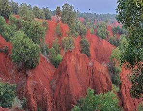
About Coastal Red Sand Dunes/Erra Matti Dibbalu:
Formation of Erra Matti Dibbalu:
- Formed around 12,000 years ago due to sea-land interaction.
- Comprises a mixture of sand (40-50%), silt and clay (another 50%) with oxidation imparting the unique red colour.
Significance of Erra Matti Dibbalu:
- They are geologically important as they represent the geological history of the late Quaternary period and carry the imprints of the fall of sea level and its subsequent rise, the impact of climate, monsoon and geological processes on the sediments.
- They are anthropologically and archeologically important as they possibly contain mesolithic and neolithic cultural materials as well.
Recognition of Erra Matti Dibbalu:
- It was recognised as a national geo-heritage site in 2014 and as a protected site by the Andhra Pradesh Government in 2016.
- The Geological Survey of India (GSI) declares geo-heritage sites/ national geological monuments for protection and maintenance.
- Other Similar Place: The only other place in the country to have a similar stretch of red sand dunes is Tamil Nadu, which has the Teri dune complex.
About Geological Survey of India:
- The Geological Survey of India (GSI) is a scientific agency of India.
- It was founded in 1851, is a Government of India Ministry of Mines organisation, one of the oldest of such organisations in the world and the second oldest survey in India after Survey of India (founded in 1767), for conducting geological surveys and studies of India.
- The main functions of the GSI relate to creation and updating of national geo-scientific information and mineral resource assessment.
- It is headquartered in Kolkata and has six regional offices located at Lucknow, Jaipur, Nagpur, Hyderabad, Shillong and Kolkata. Every state has a state unit.
- John McClelland for the first time used the term Geological Survey of India in his report in 1848. He designated himself as officiating Surveyor, Geological Survey till 1st April 1850.
- The Geological Survey of India (GSI) was set up in 1851 primarily to find coal deposits for the Railways.
- The arrival of Sir Thomas Oldham, Professor of Geology at Trinity College Dublin and the Chief of Irish Geological Survey at Calcutta on 4th March 1851, marked the beginning of the continuous period of the Geological Survey of India.
- 1951 M. S. Krishnan becomes the first Indian to be a Director of the Geological survey of India.
Source: The Hindu
Previous Year Question
Q.1) Gandikota canyon of South India was created by which one of the following rivers? (2022)
- Cauvery
- Manjira
- Pennar
- Tungabhadra


