IASbaba Prelims 60 Days Plan, Rapid Revision Series (RaRe)

Archives
Hello Friends
The 60 Days Rapid Revision (RaRe) Series is IASbaba’s Flagship Initiative recommended by Toppers and loved by the aspirants’ community every year.
It is the most comprehensive program which will help you complete the syllabus, revise and practice tests on a daily basis. The Programme on a daily basis includes
Daily Prelims MCQs from Static (Monday – Saturday)
- Daily Static Quiz will cover all the topics of static subjects – Polity, History, Geography, Economics, Environment and Science and technology.
- 20 questions will be posted daily and these questions are framed from the topics mentioned in the schedule.
- It will ensure timely and streamlined revision of your static subjects.
Daily Current Affairs MCQs (Monday – Saturday)
- Daily 5 Current Affairs questions, based on sources like ‘The Hindu’, ‘Indian Express’ and ‘PIB’, would be published from Monday to Saturday according to the schedule.
Daily CSAT Quiz (Monday – Friday)
- CSAT has been an Achilles heel for many aspirants.
- Daily 5 CSAT Questions will be published.
Note – Daily Test of 20 static questions, 10 current affairs, and 5 CSAT questions. (35 Prelims Questions) in QUIZ FORMAT will be updated on a daily basis.
To Know More about 60 Days Rapid Revision (RaRe) Series – CLICK HERE
60 Day Rapid Revision (RaRe) Series Schedule – CLICK HERE
Important Note
- Comment your Scores in the Comment Section. This will keep you accountable, responsible and sincere in days to come.
- It will help us come out with the Cut-Off on a Daily Basis.
- Let us know if you enjoyed today’s test 🙂
- You can post your comments in the given format
- (1) Your Score
- (2) Matrix Meter
- (3) New Learning from the Test
Test-summary
0 of 35 questions completed
Questions:
- 1
- 2
- 3
- 4
- 5
- 6
- 7
- 8
- 9
- 10
- 11
- 12
- 13
- 14
- 15
- 16
- 17
- 18
- 19
- 20
- 21
- 22
- 23
- 24
- 25
- 26
- 27
- 28
- 29
- 30
- 31
- 32
- 33
- 34
- 35
Information
The following Test is based on the syllabus of 60 Days Plan-2025 for UPSC IAS Prelims 2025.
To view Solutions, follow these instructions:
- Click on – ‘Start Test’ button
- Solve Questions
- Click on ‘Test Summary’ button
- Click on ‘Finish Test’ button
- Now click on ‘View Questions’ button – here you will see solutions and links.
You have already completed the test before. Hence you can not start it again.
Test is loading...
You must sign in or sign up to start the test.
You have to finish following test, to start this test:
Results
0 of 35 questions answered correctly
Your time:
Time has elapsed
You have scored 0 points out of 0 points, (0)
| Average score |
|
| Your score |
|
Categories
- Not categorized 0%
| Pos. | Name | Entered on | Points | Result |
|---|---|---|---|---|
| Table is loading | ||||
| No data available | ||||
- 1
- 2
- 3
- 4
- 5
- 6
- 7
- 8
- 9
- 10
- 11
- 12
- 13
- 14
- 15
- 16
- 17
- 18
- 19
- 20
- 21
- 22
- 23
- 24
- 25
- 26
- 27
- 28
- 29
- 30
- 31
- 32
- 33
- 34
- 35
- Answered
- Review
-
Question 1 of 35
1. Question
Which of the following correctly describes the differences between the Western Ghats and the Eastern Ghats of India?
- Compared to the Eastern Ghats, the Western Ghats generally receive higher rainfall.
- Compared to the Eastern Ghats, the Western Ghats are higher in elevation and are more continuous.
- Western Ghats are spread across four states of India whereas Eastern Ghats are spread across three states of India.
Select the correct answer using the code given below:
Correct
Solution (b)
Explanation:
- The Deccan Plateau is bordered by the Western Ghats in the west and Eastern Ghats in the east.
- Western Ghats generally receive more rainfall than the Eastern Ghats. It is because the Western Ghats block rain-bearing winds which cause rainfall on the western slopes. Whereas South-west monsoon moves parallel to the Eastern Ghats, which cause less rainfall. So, statement 1 is correct.
- Western Ghats are comparatively higher in elevation and more continuous than the Eastern Ghats. The average elevation of the Eastern Ghats is 600m and Western Ghats is from 900 to 1200 metres. Western Ghats lie parallel to the western coast of India. They are a continuous chain of mountains. They do have any major breaks and thus can be crossed through passes only. The Eastern Ghats are discontinuous and irregular and dissected by rivers draining into the Bay of Bengal. Eastern Ghats are a highly broken and discontinuous chain of hill ranges running parallel to the eastern coast of India. So, statement 2 is correct.
- Western Ghats are spread across six states of India: Gujarat, Maharashtra, Goa, Karnataka, Tamil Nadu, and Kerala. Western Ghats are locally known by different names such as Sahyadri in Maharashtra, Nilgiri hills in Karnataka and Tamil Nadu and Anaimalai hills and Cardamom hills in Kerala.
- Eastern Ghats are spread over five states of Odisha, Andhra Pradesh, Telangana, Karnataka and Tamil Nadu. So, statement 3 is not correct.
- The Eastern and the Western Ghats meet each other at the Nilgiri hills.
Incorrect
Solution (b)
Explanation:
- The Deccan Plateau is bordered by the Western Ghats in the west and Eastern Ghats in the east.
- Western Ghats generally receive more rainfall than the Eastern Ghats. It is because the Western Ghats block rain-bearing winds which cause rainfall on the western slopes. Whereas South-west monsoon moves parallel to the Eastern Ghats, which cause less rainfall. So, statement 1 is correct.
- Western Ghats are comparatively higher in elevation and more continuous than the Eastern Ghats. The average elevation of the Eastern Ghats is 600m and Western Ghats is from 900 to 1200 metres. Western Ghats lie parallel to the western coast of India. They are a continuous chain of mountains. They do have any major breaks and thus can be crossed through passes only. The Eastern Ghats are discontinuous and irregular and dissected by rivers draining into the Bay of Bengal. Eastern Ghats are a highly broken and discontinuous chain of hill ranges running parallel to the eastern coast of India. So, statement 2 is correct.
- Western Ghats are spread across six states of India: Gujarat, Maharashtra, Goa, Karnataka, Tamil Nadu, and Kerala. Western Ghats are locally known by different names such as Sahyadri in Maharashtra, Nilgiri hills in Karnataka and Tamil Nadu and Anaimalai hills and Cardamom hills in Kerala.
- Eastern Ghats are spread over five states of Odisha, Andhra Pradesh, Telangana, Karnataka and Tamil Nadu. So, statement 3 is not correct.
- The Eastern and the Western Ghats meet each other at the Nilgiri hills.
-
Question 2 of 35
2. Question
With reference to the extent of India, consider the following statements:
Statement -I: The North-South extent of Indian mainland is longer than its East-West extent.
Statement -II: Unlike longitudes, the distance between two latitudes decreases as one moves from the Equator toward the Poles.
Which one of the following is correct in respect of the statements given above?
Correct
Solution (c)
Explanation:
- The mainland of India extends between latitudes 8°4’N and 37°6’N and longitudes 68°7’E and 97°25’E. Thus, the latitudinal extent and the longitudinal extent of India is roughy the same i.e 30 degree. But the actual distance measured from North to South is not same as East to West. The North-South extent of Indian mainland is roughly 3124 km and East-West extent is about 2933 km. Thus the North-South extent of Indian mainland is longer than its East-West extent. So, Statement I is correct.
- The reason why North-South extent is not same as East-West extent is that the distance between two longitudes decreases as one moves from the Equator toward the Poles. However, the distance between two latitudes is same everywhere. So, Statement II is not correct.
- The distance between two latitudes is fixed between any two points and does not vary according to the location, area or shape. On the other hand, the longitudes are not parallel lines and the distance between the longitudinal lines vary from equator to the poles. The distance is minimum at the poles and maximum near the equator.
Incorrect
Solution (c)
Explanation:
- The mainland of India extends between latitudes 8°4’N and 37°6’N and longitudes 68°7’E and 97°25’E. Thus, the latitudinal extent and the longitudinal extent of India is roughy the same i.e 30 degree. But the actual distance measured from North to South is not same as East to West. The North-South extent of Indian mainland is roughly 3124 km and East-West extent is about 2933 km. Thus the North-South extent of Indian mainland is longer than its East-West extent. So, Statement I is correct.
- The reason why North-South extent is not same as East-West extent is that the distance between two longitudes decreases as one moves from the Equator toward the Poles. However, the distance between two latitudes is same everywhere. So, Statement II is not correct.
- The distance between two latitudes is fixed between any two points and does not vary according to the location, area or shape. On the other hand, the longitudes are not parallel lines and the distance between the longitudinal lines vary from equator to the poles. The distance is minimum at the poles and maximum near the equator.
-
Question 3 of 35
3. Question
Test question
Correct
Test explained
Incorrect
Test explained
-
Question 4 of 35
4. Question
Consider the following Statements regarding ‘Karewas’:
- It is an erosional feature created by a water body that only exists temporarily.
- They are characterized by the presence of fossils of mammals and peat.
- The formations of Karewas are useful for the cultivation of Saffron in Kashmir Valley.
Which of the statements given above is/are correct?
Correct
Solution (b)
Explanation:
- In Kashmiri, the word Karewa means “elevated tableland.” Godwin-Austin (1859) coined the phrase, which was later used by Lydekker (1878), to describe an unconsolidated to semi-consolidated sand-clay-conglomerate succession.
- Statement 1 is incorrect: Karewas are the thick deposits of glacial clay and other materials embedded with moraines. The fertility of these patches is the result of their long history of formation. It was formed during the Pleistocene period (1 million Years Ago). Sediments continued to flow in from rivers and deposit in the lake, eventually resulting in the formation of a lacustrine plain. Over time, the water drained away, leaving behind deposits such as unconsolidated gravel and sludge.
- Statement 2 is correct: Karewas are characterized by the presence of fossils of mammals and places filled with peat. This makes them ideal for cultivation of saffron, almonds, apples and several other cash crops. It is mainly found in the Kashmir valley between Pir Panjal and Zaskar range in the Himalayas. (Hence statement 2 is correct)
- Statement 3 is correct: Karewa formations are useful for the cultivation of Zafran, a local variety of Saffron in Kashmir valley. The Karewa sediments hold fossils and remnants of many human civilisations and habitations, Hence, are the most fertile spots in the valley. Karewa deposits have different soil and sediments such as sand, clay, silt, shale, mud, lignite and losses. Hence, these are very useful for agricultural and horticulture activities. (Hence statement 3 is correct)
Incorrect
Solution (b)
Explanation:
- In Kashmiri, the word Karewa means “elevated tableland.” Godwin-Austin (1859) coined the phrase, which was later used by Lydekker (1878), to describe an unconsolidated to semi-consolidated sand-clay-conglomerate succession.
- Statement 1 is incorrect: Karewas are the thick deposits of glacial clay and other materials embedded with moraines. The fertility of these patches is the result of their long history of formation. It was formed during the Pleistocene period (1 million Years Ago). Sediments continued to flow in from rivers and deposit in the lake, eventually resulting in the formation of a lacustrine plain. Over time, the water drained away, leaving behind deposits such as unconsolidated gravel and sludge.
- Statement 2 is correct: Karewas are characterized by the presence of fossils of mammals and places filled with peat. This makes them ideal for cultivation of saffron, almonds, apples and several other cash crops. It is mainly found in the Kashmir valley between Pir Panjal and Zaskar range in the Himalayas. (Hence statement 2 is correct)
- Statement 3 is correct: Karewa formations are useful for the cultivation of Zafran, a local variety of Saffron in Kashmir valley. The Karewa sediments hold fossils and remnants of many human civilisations and habitations, Hence, are the most fertile spots in the valley. Karewa deposits have different soil and sediments such as sand, clay, silt, shale, mud, lignite and losses. Hence, these are very useful for agricultural and horticulture activities. (Hence statement 3 is correct)
-
Question 5 of 35
5. Question
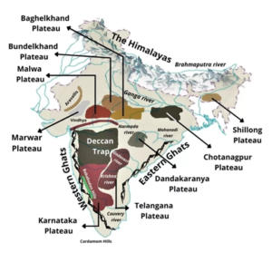
Arrange the following plateaus of Peninsular India in East to West direction:
- Malwa Plateau
- Hazaribagh Plateau
- Marwar Plateau
- Karbi Anglong
- Baghelkhand Plateau
Select the correct option using the code given below:
 Correct
Solution (d)
Explanation:
- The Peninsular Plateau Region is one of the physiographic divisions of India. It is an old stable mass of rocks that forms the core of the Indian tectonic subplate. It consists of many old denuded plateaus that were once mountains. They are rich in minerals. They are bound by ranges like the Aravali, Delhi Ridge, Vindhyas, Maikal in the north, the Gir Hills in the west, the Rajmahal Hills in the East and the Cardamom Hills in the South, they are a roughly triangular shaped region made of many smaller plateaus.
- Option 1: The Malwa Plateau lies atop the Vindhya range in South and is bounded by the Aravali range in the west. It lies in the region straddling south east portions of Rajasthan and western regions of Madhya Pradesh. It comprises the northwest part of the Deccan traps and has black soil.
- Option 2: The Hazaribagh Plateau is one the plateaus making up the Chota Nagpur Plateau complex in the East. Roughly spreading over the Southern part of Bihar, Northern Jharkhand and middle west part of West Bengal, this plateau lies north of the river Damodar. It has an average elevation of 600 m above mean sea level. This plateau has isolated hills; Parasnath in the east rises to 1,366 m. The area is made of granite and gneiss while the hills have quartz rocks. It looks like a peneplain due to large scale erosion.
- Option 3: The Marwar Plateau is the westernmost plateau of the Peninsular Plateau region. It is bounded by the Aravali range in the west and the Malwa Plateau in the east. It is distinct from the Malwa Plateau as it is not a part of the Deccan Trap. It occupies the eastern portion of Rajasthan. The average elevation of this area is 250-500 m above sea level and it slopes down eastwards. It is made up of sandstone, shales and limestones of the Vindhyan period. The Banas River originates in the Aravali Range and flows for about 400 km before joining the Chambal River.
- Option 4: Karbi Anglong is a part of the Shillong/ Meghalaya Plateau present in the North East. It has been separated from the main part of the Peninsular plateau region by the Malda fault. It is present on the western fringe of the Shillong Plateau and occupies some areas of Assam as well. It is largely formed by Archaean (Dharwarian) quartzites, shales and schists with granite intrusions and some basic silt.
- Option 5: The Baghelkhand Plateau lies east of the Maikal range and occupies the region straddling east Madhya Pradesh and north west Chhattisgarh. It lies slightly south and east compared to the Bundelkhand region. It is made of limestone and sandstones in the west and granite in the east. It is bounded by the son River in the north. It acts as a watershed between the Son River in the north and the Mahanadi in the south.
Incorrect
Solution (d)
Explanation:
- The Peninsular Plateau Region is one of the physiographic divisions of India. It is an old stable mass of rocks that forms the core of the Indian tectonic subplate. It consists of many old denuded plateaus that were once mountains. They are rich in minerals. They are bound by ranges like the Aravali, Delhi Ridge, Vindhyas, Maikal in the north, the Gir Hills in the west, the Rajmahal Hills in the East and the Cardamom Hills in the South, they are a roughly triangular shaped region made of many smaller plateaus.
- Option 1: The Malwa Plateau lies atop the Vindhya range in South and is bounded by the Aravali range in the west. It lies in the region straddling south east portions of Rajasthan and western regions of Madhya Pradesh. It comprises the northwest part of the Deccan traps and has black soil.
- Option 2: The Hazaribagh Plateau is one the plateaus making up the Chota Nagpur Plateau complex in the East. Roughly spreading over the Southern part of Bihar, Northern Jharkhand and middle west part of West Bengal, this plateau lies north of the river Damodar. It has an average elevation of 600 m above mean sea level. This plateau has isolated hills; Parasnath in the east rises to 1,366 m. The area is made of granite and gneiss while the hills have quartz rocks. It looks like a peneplain due to large scale erosion.
- Option 3: The Marwar Plateau is the westernmost plateau of the Peninsular Plateau region. It is bounded by the Aravali range in the west and the Malwa Plateau in the east. It is distinct from the Malwa Plateau as it is not a part of the Deccan Trap. It occupies the eastern portion of Rajasthan. The average elevation of this area is 250-500 m above sea level and it slopes down eastwards. It is made up of sandstone, shales and limestones of the Vindhyan period. The Banas River originates in the Aravali Range and flows for about 400 km before joining the Chambal River.
- Option 4: Karbi Anglong is a part of the Shillong/ Meghalaya Plateau present in the North East. It has been separated from the main part of the Peninsular plateau region by the Malda fault. It is present on the western fringe of the Shillong Plateau and occupies some areas of Assam as well. It is largely formed by Archaean (Dharwarian) quartzites, shales and schists with granite intrusions and some basic silt.
- Option 5: The Baghelkhand Plateau lies east of the Maikal range and occupies the region straddling east Madhya Pradesh and north west Chhattisgarh. It lies slightly south and east compared to the Bundelkhand region. It is made of limestone and sandstones in the west and granite in the east. It is bounded by the son River in the north. It acts as a watershed between the Son River in the north and the Mahanadi in the south.
-
Question 6 of 35
6. Question
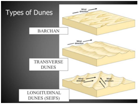
Which one of the following statements correctly describe the term ‘Dhrians’, in the context of Indian geography?
Correct
Solution (b)
Explanation:
- Sand dunes is a land of undulating topography dotted with longitudinal dunes, transverse dunes and barchans. Barchan – A crescent-shaped sand dune, the horns of which point away from the direction of the dominant wind; Longitudinal dune – A sand dune with its crest running parallel to the direction of prevailing wind.
- In desert regions, due to change in the direction of winds, the sand dunes shift from one place to the other. These moving or shifting dunes are called ‘dhrians’ in the desert region of Rajasthan.
- Episodic rivers are formed from run-off channels and found in areas with very dry climates.
- Moraines are the material usually soil and rock left behind by a moving glacier.
- Dykes are sheets of rock that is formed in a fracture of a pre-existing rock body.
 Incorrect
Solution (b)
Explanation:
- Sand dunes is a land of undulating topography dotted with longitudinal dunes, transverse dunes and barchans. Barchan – A crescent-shaped sand dune, the horns of which point away from the direction of the dominant wind; Longitudinal dune – A sand dune with its crest running parallel to the direction of prevailing wind.
- In desert regions, due to change in the direction of winds, the sand dunes shift from one place to the other. These moving or shifting dunes are called ‘dhrians’ in the desert region of Rajasthan.
- Episodic rivers are formed from run-off channels and found in areas with very dry climates.
- Moraines are the material usually soil and rock left behind by a moving glacier.
- Dykes are sheets of rock that is formed in a fracture of a pre-existing rock body.
-
Question 7 of 35
7. Question
Which of the following pairs of water bodies and the land masses separated by them is/ are correctly matched?
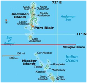
Water Body Landmass Separated 1. Eight Degree Channel Minicoy and Maldives Islands 2. Nine Degree Channel North Andaman and South Andaman Islands 3. Ten Degree Channel Andaman Islands and Nicobar Islands Select the correct option using the code given below:
Correct
Solution (c)
Explanation:

- Pair 1 is correct: The Minicoy Island of Lakshadweep group and Maldives islands are separated by a thin body of water called the Eight Degree Channel.
- Pair 2 is incorrect: The Nine Degree Channel is a thin body of water which separates the Amindivi islands from the Minicoy islands of Lakshadweep group.
- Pair 3 is correct: The Ten Degree Channel separates the Little Andaman Island of Andaman group from the Car Nicobar Island of Nicobar group of islands
 Incorrect
Solution (c)
Explanation:
- Pair 1 is correct: The Minicoy Island of Lakshadweep group and Maldives islands are separated by a thin body of water called the Eight Degree Channel.
- Pair 2 is incorrect: The Nine Degree Channel is a thin body of water which separates the Amindivi islands from the Minicoy islands of Lakshadweep group.
- Pair 3 is correct: The Ten Degree Channel separates the Little Andaman Island of Andaman group from the Car Nicobar Island of Nicobar group of islands
-
Question 8 of 35
8. Question
Which of the following rivers are the tributaries of Brahmaputra River?
- Torsa
- Feni
- Raidak
- Sankosh
- Kameng
Select the correct answer using the code given below:
Correct
Solution (a)
Explanation:
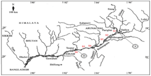
- Option a is correct. The Brahmaputra receives numerous tributaries in its 750 km long journey through the Assam valley. Its major left bank tributaries are the Burhi Dihing, Desang and Dhansari (South) whereas the important right bank tributaries are the Subansiri, Lohit, Dibang, Torsa, Kameng, Manas and Sankosh. Raidak River is also one of the right bank tributaries of Brahmaputra. It flows through Bhutan, India and Bangladesh.
- However, the Feni River, which forms part of the India-Bangladesh border, is not a tributary of Brahmaputra River. It originates in the South Tripura district, passes through Sabroom town on the Indian side, and meets the Bay of Bengal after it flows into Bangladesh.
 Incorrect
Solution (a)
Explanation:
- Option a is correct. The Brahmaputra receives numerous tributaries in its 750 km long journey through the Assam valley. Its major left bank tributaries are the Burhi Dihing, Desang and Dhansari (South) whereas the important right bank tributaries are the Subansiri, Lohit, Dibang, Torsa, Kameng, Manas and Sankosh. Raidak River is also one of the right bank tributaries of Brahmaputra. It flows through Bhutan, India and Bangladesh.
- However, the Feni River, which forms part of the India-Bangladesh border, is not a tributary of Brahmaputra River. It originates in the South Tripura district, passes through Sabroom town on the Indian side, and meets the Bay of Bengal after it flows into Bangladesh.
-
Question 9 of 35
9. Question
Which of the following statements with respect to international remittances is/are correct?
- The United States of America is the largest contributor to remittances globally
- The amount of net remittances to India is much more than combined amount of foreign direct investments (FDI) and portfolio investments.
Select the correct answer using the code below:
Correct
Solution (c)
Explanation:
Statement 1 is correct: In 2023, the United States remained the largest contributor to remittances globally. The leading recipients of these funds were India ($125 billion), followed by Mexico ($67 billion), China ($50 billion), the Philippines ($40 billion), and Egypt ($24 billion).
Statement 2 is correct: In the financial year 2023-24, Indians residing abroad sent an unprecedented $107 billion in remittances to their families in India, surpassing the $100 billion threshold for the second consecutive year, according to a report by The Economic Times.
This amount of net remittances nearly doubles the combined total of $54 billion from foreign direct investments (FDI) and portfolio investments during the same period.
Incorrect
Solution (c)
Explanation:
Statement 1 is correct: In 2023, the United States remained the largest contributor to remittances globally. The leading recipients of these funds were India ($125 billion), followed by Mexico ($67 billion), China ($50 billion), the Philippines ($40 billion), and Egypt ($24 billion).
Statement 2 is correct: In the financial year 2023-24, Indians residing abroad sent an unprecedented $107 billion in remittances to their families in India, surpassing the $100 billion threshold for the second consecutive year, according to a report by The Economic Times.
This amount of net remittances nearly doubles the combined total of $54 billion from foreign direct investments (FDI) and portfolio investments during the same period.
-
Question 10 of 35
10. Question
Which of the following are known as plantation crops?
- Turmeric
- Coffee
- Rubber
- Oil palm
- Cashew nut
Select the correct answer using the code given below:
Correct
Solution (c)
Explanation:
- Plantation agriculture is a form of commercial farming where crops are grown for profit. Large land areas are needed for this type of agriculture. Countries that have plantation agriculture usually experience high annual temperatures and receive high annual rainfall. Plantation agriculture as mentioned above was introduced by the Europeans in colonies situated in the tropics.
- Some of the important plantation crops are tea, coffee, cocoa, rubber, cotton, oil palm, sugarcane, bananas, cashew nut and pineapples. Turmeric is not grown as a plantation crop.
- The plantation has an interface of agriculture and industry. Plantations cover large tracts of land, using capital intensive inputs, with the help of migrant labourers. All the produce is used as raw material in respective industries.
PURPOSE – Plantation agriculture is a form of commercial farming where crops are grown for sale. Some crops are sold as raw materials to manufacturing industries.
INPUTS – Land: Plantations are huge and can extend from a few hectares to a few thousand hectares.
- For example, in Malaysia, an oil palm plantation is usually at least 40 hectares in size. Capital: A large amount of capital is put into building roads, buying machinery and building factories to process the crops harvested from the plantations. Plantation owners also invest large amounts of their capital on fertilizers and pesticides.
- Fertilizers are applied to plantation crops as frequently as these crops use up nutrients from the land quickly. Since plantations usually grow one type of crop, pest attacks can cause total destruction of the plantations. Pesticides are therefore used in huge quantities to prevent crops from being entirely destroyed by pests.
Incorrect
Solution (c)
Explanation:
- Plantation agriculture is a form of commercial farming where crops are grown for profit. Large land areas are needed for this type of agriculture. Countries that have plantation agriculture usually experience high annual temperatures and receive high annual rainfall. Plantation agriculture as mentioned above was introduced by the Europeans in colonies situated in the tropics.
- Some of the important plantation crops are tea, coffee, cocoa, rubber, cotton, oil palm, sugarcane, bananas, cashew nut and pineapples. Turmeric is not grown as a plantation crop.
- The plantation has an interface of agriculture and industry. Plantations cover large tracts of land, using capital intensive inputs, with the help of migrant labourers. All the produce is used as raw material in respective industries.
PURPOSE – Plantation agriculture is a form of commercial farming where crops are grown for sale. Some crops are sold as raw materials to manufacturing industries.
INPUTS – Land: Plantations are huge and can extend from a few hectares to a few thousand hectares.
- For example, in Malaysia, an oil palm plantation is usually at least 40 hectares in size. Capital: A large amount of capital is put into building roads, buying machinery and building factories to process the crops harvested from the plantations. Plantation owners also invest large amounts of their capital on fertilizers and pesticides.
- Fertilizers are applied to plantation crops as frequently as these crops use up nutrients from the land quickly. Since plantations usually grow one type of crop, pest attacks can cause total destruction of the plantations. Pesticides are therefore used in huge quantities to prevent crops from being entirely destroyed by pests.
-
Question 11 of 35
11. Question
In which one of the following regions is extensive commercial grain cultivation not generally practiced?
Correct
Solution (d)
Explanation:
- Amazon Basin is the largest tropical forest in the world. Extensive agriculture is not practiced here. Mostly people practice shifting cultivation here.
- Commercial Grain Farming is an extensive agricultural activity whereby crops are grown for commercial purpose. Most commonly commercial grown grains are wheat and maize.
- It is mostly practiced in temperate grasslands of North America, Europe and Asia.
- Commercial grain farming of wheat
- There are four major areas in the world known for commercial farming of wheat. These are US and Canadian Prairies; Eurasian Steppes; Argentine Pampas and Downs of Australia.
Option a is incorrect. American Canadian prairies experience dry semi-arid climates with an annual precipitation of 12 to 15 inches which is suitable for commercial grain cultivation.
Option b is incorrect. European steppes are the largest temperate steppe and experience semi-arid climate which is best for commercial grain cultivation.
Option c is incorrect. Pampas of Argentina is also semi-arid region. Wheat is Argentina’s largest crop in harvested land area.
Incorrect
Solution (d)
Explanation:
- Amazon Basin is the largest tropical forest in the world. Extensive agriculture is not practiced here. Mostly people practice shifting cultivation here.
- Commercial Grain Farming is an extensive agricultural activity whereby crops are grown for commercial purpose. Most commonly commercial grown grains are wheat and maize.
- It is mostly practiced in temperate grasslands of North America, Europe and Asia.
- Commercial grain farming of wheat
- There are four major areas in the world known for commercial farming of wheat. These are US and Canadian Prairies; Eurasian Steppes; Argentine Pampas and Downs of Australia.
Option a is incorrect. American Canadian prairies experience dry semi-arid climates with an annual precipitation of 12 to 15 inches which is suitable for commercial grain cultivation.
Option b is incorrect. European steppes are the largest temperate steppe and experience semi-arid climate which is best for commercial grain cultivation.
Option c is incorrect. Pampas of Argentina is also semi-arid region. Wheat is Argentina’s largest crop in harvested land area.
-
Question 12 of 35
12. Question
In which of the following types of agriculture is the farming of citrus fruit very important?
Correct
Solution (c)
Explanation:
The term ‘Mediterranean agriculture’ applies to the agriculture done in those regions which are having Mediterranean type of climate. This type of agriculture is determined by climatic conditions, which exert such an influence that both traditional and commercial agriculture flourish with a dominance of the agriculture of citrus fruits along with horticulture and floriculture. This region is an important supplier of citrus fruits.
Viticulture or grape cultivation is a speciality of the Mediterranean region. Best quality wines in the world with distinctive flavours are produced from high quality grapes in various countries of this region. The inferior grapes are dried into raisins and currants. This region also produces olives and figs.
Option a is incorrect. Market gardening and Horticulture: A market garden is relatively small-scale production of fruits, vegetables and flowers as cash crops, frequently sold directly to consumers and restaurants.
Market gardening and horticulture specialize in the cultivation of high value crops such as vegetables, fruits and flowers, solely for the urban markets. Farms are small and are located where there are good transportation links with the urban centre where high income group of consumers is located. It is both labour and capital intensive and lays emphasis on the use of irrigation, HYV seeds, fertilisers, insecticides, greenhouses and artificial heating in colder regions.
Option b is incorrect. Plantation Agriculture: plantation agriculture is the cultivation of a single cash crop on a large scale in a professional way.
Option d is incorrect. Co-operative Farming: A group of farmers forms a co-operative society by pooling in their resources voluntarily for more efficient and profitable farming. Individual farms remain intact and farming is a matter of cooperative initiative.
Incorrect
Solution (c)
Explanation:
The term ‘Mediterranean agriculture’ applies to the agriculture done in those regions which are having Mediterranean type of climate. This type of agriculture is determined by climatic conditions, which exert such an influence that both traditional and commercial agriculture flourish with a dominance of the agriculture of citrus fruits along with horticulture and floriculture. This region is an important supplier of citrus fruits.
Viticulture or grape cultivation is a speciality of the Mediterranean region. Best quality wines in the world with distinctive flavours are produced from high quality grapes in various countries of this region. The inferior grapes are dried into raisins and currants. This region also produces olives and figs.
Option a is incorrect. Market gardening and Horticulture: A market garden is relatively small-scale production of fruits, vegetables and flowers as cash crops, frequently sold directly to consumers and restaurants.
Market gardening and horticulture specialize in the cultivation of high value crops such as vegetables, fruits and flowers, solely for the urban markets. Farms are small and are located where there are good transportation links with the urban centre where high income group of consumers is located. It is both labour and capital intensive and lays emphasis on the use of irrigation, HYV seeds, fertilisers, insecticides, greenhouses and artificial heating in colder regions.
Option b is incorrect. Plantation Agriculture: plantation agriculture is the cultivation of a single cash crop on a large scale in a professional way.
Option d is incorrect. Co-operative Farming: A group of farmers forms a co-operative society by pooling in their resources voluntarily for more efficient and profitable farming. Individual farms remain intact and farming is a matter of cooperative initiative.
-
Question 13 of 35
13. Question
With reference to the Copper deposits in India, which of the following statements are correct?
- Khetri mine in Rajasthan is largest copper producing mine in India.
- The majority of copper is used in electrical industry.
- Odisha has largest reserves of copper ore in India.
- Majority of copper ore occurs in igneous and sedimentary rocks.
Select the correct answer using the codes given below:
Correct
Solution (b)
Explanation:
Statement 1 is incorrect. The Malanjkhand mine is the largest copper producing mine in India. It is a surface and underground mine located in Madhya Pradesh. It is owned by Hindustan Copper and produced an estimated 19.927 thousand tonnes of copper in 2020. The mine will operate until 2036.
Statement 2 is correct. The majority of copper production, about three-quarters, is used by the electrical industries to make electrical wires, telecommunication cables, and electronics. (Hence statement 2 is correct).
Statement 3 is incorrect. Largest reserves/resources of copper ore to a tune of 813 million tonnes (53.81%) are in the state of Rajasthan followed by Jharkhand with 295 million tonnes (19.54%) and Madhya Pradesh with 283 million tonnes (18.75%).
Statement 4 is correct. Mostly copper occurs in ores of igneous (volcanic) rock and sedimentary rock. To process copper commercial, the copper is first extracted from its ores through smelting and is then put through electrodeposition from sulphate solutions.Incorrect
Solution (b)
Explanation:
Statement 1 is incorrect. The Malanjkhand mine is the largest copper producing mine in India. It is a surface and underground mine located in Madhya Pradesh. It is owned by Hindustan Copper and produced an estimated 19.927 thousand tonnes of copper in 2020. The mine will operate until 2036.
Statement 2 is correct. The majority of copper production, about three-quarters, is used by the electrical industries to make electrical wires, telecommunication cables, and electronics. (Hence statement 2 is correct).
Statement 3 is incorrect. Largest reserves/resources of copper ore to a tune of 813 million tonnes (53.81%) are in the state of Rajasthan followed by Jharkhand with 295 million tonnes (19.54%) and Madhya Pradesh with 283 million tonnes (18.75%).
Statement 4 is correct. Mostly copper occurs in ores of igneous (volcanic) rock and sedimentary rock. To process copper commercial, the copper is first extracted from its ores through smelting and is then put through electrodeposition from sulphate solutions. -
Question 14 of 35
14. Question
Consider the following pairs about shifting cultivation and their location:
Shifting Cultivation Location - Podu
Western Ghats - Kumari
Himalayan Belt - Valre
Assam - Kuruwa
Jharkhand How many of the pairs given above are correctly matched?
Correct
Solution (a)
Explanation:
Shifting cultivation, also known as shifting farming, is a technique of agriculture in which primitive people of the tropical forest relocate their plots of agricultural land by clearing the forest with fire. It is also known as migrating primitive agriculture.
Pair 1 is incorrect. ‘Podu’ or ‘Penda’ cultivation is a type of shifting cultivation that uses slash and burn practices. This is widely used by tribes living in Andhra Pradesh and Telangana areas.
Pair 2 is incorrect. ‘Kumari’ is a type of shifting agriculture practiced in the Western Ghats.
Pair 3 is incorrect. ‘Valre’ or ‘Waltre’ agriculture is a type of shifting agriculture practiced in south-eastern Rajasthan.
Pair 4 is correct. ‘Kuruwa’ is the shifting agriculture used in Jharkhand, and ‘Jhumming’ in the north-eastern region.(Hence pair 4 is correct)
Incorrect
Solution (a)
Explanation:
Shifting cultivation, also known as shifting farming, is a technique of agriculture in which primitive people of the tropical forest relocate their plots of agricultural land by clearing the forest with fire. It is also known as migrating primitive agriculture.
Pair 1 is incorrect. ‘Podu’ or ‘Penda’ cultivation is a type of shifting cultivation that uses slash and burn practices. This is widely used by tribes living in Andhra Pradesh and Telangana areas.
Pair 2 is incorrect. ‘Kumari’ is a type of shifting agriculture practiced in the Western Ghats.
Pair 3 is incorrect. ‘Valre’ or ‘Waltre’ agriculture is a type of shifting agriculture practiced in south-eastern Rajasthan.
Pair 4 is correct. ‘Kuruwa’ is the shifting agriculture used in Jharkhand, and ‘Jhumming’ in the north-eastern region.(Hence pair 4 is correct)
-
Question 15 of 35
15. Question
With reference to the wind energy generation in India, consider the following statements:
- India is the largest producer of wind energy in the world
- Tamil Nadu has the highest installed capacity of wind energy in India.
- Wind energy generation in India is highest during the months of February to May.
Which of the statement(s) given above is/are correct?
Correct
Solution (d)
Explanation:
Statement 1 is incorrect. India currently has the fourth highest wind installed capacity in the world with a total installed capacity of 47.36 GW.
Statement 2 is incorrect. Gujarat has the highest wind power installed capacity in India followed by Tamil Nadu. Gujarat had 11,823 MW of installed wind power capacity as of May 2024, while Tamil Nadu had 10,743 MW. Karnataka is ranked third with 6312 MW.
Statement 3 is incorrect. Wind energy generation is the highest from June to September. India’ wind power generation has the peak wind season that begins in June and ends in September. Peak season accounting for 3/4th of India’ annual wind power generation.
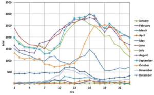
Fig 1: Typical daily wind energy generation pattern month-wise in Tamil Nadu
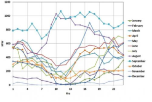
Fig 2: Typical daily wind energy generation pattern month-wise in Gujarat.
Incorrect
Solution (d)
Explanation:
Statement 1 is incorrect. India currently has the fourth highest wind installed capacity in the world with a total installed capacity of 47.36 GW.
Statement 2 is incorrect. Gujarat has the highest wind power installed capacity in India followed by Tamil Nadu. Gujarat had 11,823 MW of installed wind power capacity as of May 2024, while Tamil Nadu had 10,743 MW. Karnataka is ranked third with 6312 MW.
Statement 3 is incorrect. Wind energy generation is the highest from June to September. India’ wind power generation has the peak wind season that begins in June and ends in September. Peak season accounting for 3/4th of India’ annual wind power generation.
Fig 1: Typical daily wind energy generation pattern month-wise in Tamil Nadu
Fig 2: Typical daily wind energy generation pattern month-wise in Gujarat.
-
Question 16 of 35
16. Question
Consider the following statements with reference to rare earth metals (REMs):
- They are characterized by high density, high melting point and high conductivity.
- Scandium and Yttrium are rare earth metals.
- Presently, China produces and mines more than 90% of rare earth elements.
Which of the statements given above is/are correct?
Correct
Solution (c)
Explanation:
Statement 1 is correct. Rare earth elements (REE) are characterized by high density, high melting point, high conductivity and high thermal conductance. A number of rare earth minerals contain thorium and uranium in variable amounts, but they do not constitute essential components in the composition of the minerals. (Hence statement 1 is correct)
Statement 2 is correct. Rare Earth Elements (REE) are metals having many similar properties. Rare earth elements (REE) are a group of seventeen chemical elements that occur together in the periodic table, 15 lanthanides, Scandium and Yttrium. They are Samarium (Sm), scandium (Sc), terbium (Tb), thulium (Tm), ytterbium (Yb), yttrium (Y), cerium (Ce), dysprosium (Dy), erbium (Er), europium (Eu), gadolinium (Gd), holmium (Ho), lanthanum (La), lutetium (Lu), neodymium (Nd), praseodymium (Pr), promethium (Pm).
They are not rare in quantity, in fact, some of them are very abundant in earth’s crust for example, cerium is more abundant than copper and lead. However, their extraction is very difficult.
Statement 3 is correct. The global demand for REMs has increased significantly in line with their expansion into high-end technology, environment, and economic areas. Currently, China has control over 94% in producing and mining REMs and further China has very high natural reserves for these. As per some recent reports, China is even buying this reserve in others countries and regions to have a monopoly over production for a very long time. And due to these very reasons, it has become very critical metal for India since India is not having enough resources and it further suffers technological constraints in mining its own reserves of REMs. (Hence statement 3 is correct).
Incorrect
Solution (c)
Explanation:
Statement 1 is correct. Rare earth elements (REE) are characterized by high density, high melting point, high conductivity and high thermal conductance. A number of rare earth minerals contain thorium and uranium in variable amounts, but they do not constitute essential components in the composition of the minerals. (Hence statement 1 is correct)
Statement 2 is correct. Rare Earth Elements (REE) are metals having many similar properties. Rare earth elements (REE) are a group of seventeen chemical elements that occur together in the periodic table, 15 lanthanides, Scandium and Yttrium. They are Samarium (Sm), scandium (Sc), terbium (Tb), thulium (Tm), ytterbium (Yb), yttrium (Y), cerium (Ce), dysprosium (Dy), erbium (Er), europium (Eu), gadolinium (Gd), holmium (Ho), lanthanum (La), lutetium (Lu), neodymium (Nd), praseodymium (Pr), promethium (Pm).
They are not rare in quantity, in fact, some of them are very abundant in earth’s crust for example, cerium is more abundant than copper and lead. However, their extraction is very difficult.
Statement 3 is correct. The global demand for REMs has increased significantly in line with their expansion into high-end technology, environment, and economic areas. Currently, China has control over 94% in producing and mining REMs and further China has very high natural reserves for these. As per some recent reports, China is even buying this reserve in others countries and regions to have a monopoly over production for a very long time. And due to these very reasons, it has become very critical metal for India since India is not having enough resources and it further suffers technological constraints in mining its own reserves of REMs. (Hence statement 3 is correct).
-
Question 17 of 35
17. Question
With reference to the population of a particular region, consider the following statements:
- Physiological density of population is determined by dividing the total population of a region by its total land area.
- Agricultural density of population is calculated by dividing the total agricultural population in a particular region by its total population.
- Agricultural population of a particular region includes the agricultural labourers, farmers and their family members.
How many of the statements given above are correct?
Correct
Solution (a)
Explanation:
The population density is a crude measure of the relationship between humans and land. The physiological and agricultural densities should be determined in order to have a better understanding of the human-land ratio in terms of the pressure of population on total cultivable land.
Statement 1 is incorrect. The physiological density of population is determined by dividing the total population of a region by its cultivated land area. Physiological density provides the accurate representation of the human pressure on the land.
Statement 2 is incorrect. Agricultural density of population is calculated by dividing the total agricultural population in a particular region by its net cultivable land area. It has proved to be an effective indicator of the human-land relationship, particularly in an agrarian context.
Statement 3 is correct. The agricultural population constitutes the cultivators, agricultural labourers, and their families. (Hence statement 3 is correct).
Incorrect
Solution (a)
Explanation:
The population density is a crude measure of the relationship between humans and land. The physiological and agricultural densities should be determined in order to have a better understanding of the human-land ratio in terms of the pressure of population on total cultivable land.
Statement 1 is incorrect. The physiological density of population is determined by dividing the total population of a region by its cultivated land area. Physiological density provides the accurate representation of the human pressure on the land.
Statement 2 is incorrect. Agricultural density of population is calculated by dividing the total agricultural population in a particular region by its net cultivable land area. It has proved to be an effective indicator of the human-land relationship, particularly in an agrarian context.
Statement 3 is correct. The agricultural population constitutes the cultivators, agricultural labourers, and their families. (Hence statement 3 is correct).
-
Question 18 of 35
18. Question
Which of the following statements are correct regarding the application/usage of minerals?
- Bauxite is mainly used in the manufacturing of aluminium.
- Copper is mixed with gold to provide strength to jewellery.
- Mica is widely used as a conductor in electrical appliances.
- Manganese is used in the manufacturing of steel.
Select the correct answer using the code given below:
Correct
Solution (d)
Explanation:
- Bauxite is the ore which is used in manufacturing of aluminium. It is the only ore used for large-scale aluminium production. Bauxite is also used in abrasive and chemical industries. Bauxite is found mainly in tertiary deposits and is associated with laterite rocks occurring extensively either on the plateau or hill ranges of peninsular India and also in the coastal tracts of the country. Odisha happens to be the largest producer of Bauxite. So, statement 1 is correct.
- Copper is an important metal in the electrical industry. It is used for making wires, electric motors, transformers and generators. It is alloyable, malleable and ductile. It is also mixed with gold to provide strength to jewellery. Pure gold is very soft and malleable. Copper makes it stronger, harder and less brittle in nature. The Copper deposits mainly occur in Singhbhum district in Jharkhand, Balaghat district in Madhya Pradesh and Jhunjhunu and Alwar districts in Rajasthan. So, statement 2 is correct.
- Mica has a high heat tolerance and is a poor conductor of electricity. Mica is mainly used in the electrical and electronic industries. Mica’s exceptional dielectric strength and heat resistance make it an ideal material for electrical insulation. It is commonly used in the production of insulating materials for electrical appliances, cables, and circuit boards. Mica’s ability to withstand high temperatures and resist electrical currents ensures the safety and reliability of electrical systems. Mica in India is mainly produced in Jharkhand, Andhra Pradesh, Telanganga and Rajasthan. So, statement 3 is not correct.
- Manganese is mainly used in the manufacturing of steel and ferro-manganese alloy. Nearly 10 kg of manganese is required to manufacture one tonne of steel. It is used as an alloy in the manufacture of steel to increase its hardness. It is also used in the manufacture of chemicals, chemical fertilizers, bleaching powder, insecticides and paints. Odisha is the leading producer of Manganese. So, statement 4 is correct.
Incorrect
Solution (d)
Explanation:
- Bauxite is the ore which is used in manufacturing of aluminium. It is the only ore used for large-scale aluminium production. Bauxite is also used in abrasive and chemical industries. Bauxite is found mainly in tertiary deposits and is associated with laterite rocks occurring extensively either on the plateau or hill ranges of peninsular India and also in the coastal tracts of the country. Odisha happens to be the largest producer of Bauxite. So, statement 1 is correct.
- Copper is an important metal in the electrical industry. It is used for making wires, electric motors, transformers and generators. It is alloyable, malleable and ductile. It is also mixed with gold to provide strength to jewellery. Pure gold is very soft and malleable. Copper makes it stronger, harder and less brittle in nature. The Copper deposits mainly occur in Singhbhum district in Jharkhand, Balaghat district in Madhya Pradesh and Jhunjhunu and Alwar districts in Rajasthan. So, statement 2 is correct.
- Mica has a high heat tolerance and is a poor conductor of electricity. Mica is mainly used in the electrical and electronic industries. Mica’s exceptional dielectric strength and heat resistance make it an ideal material for electrical insulation. It is commonly used in the production of insulating materials for electrical appliances, cables, and circuit boards. Mica’s ability to withstand high temperatures and resist electrical currents ensures the safety and reliability of electrical systems. Mica in India is mainly produced in Jharkhand, Andhra Pradesh, Telanganga and Rajasthan. So, statement 3 is not correct.
- Manganese is mainly used in the manufacturing of steel and ferro-manganese alloy. Nearly 10 kg of manganese is required to manufacture one tonne of steel. It is used as an alloy in the manufacture of steel to increase its hardness. It is also used in the manufacture of chemicals, chemical fertilizers, bleaching powder, insecticides and paints. Odisha is the leading producer of Manganese. So, statement 4 is correct.
-
Question 19 of 35
19. Question
Consider the following statements:
- Minor minerals include ‘’all minerals that are not declared as ‘major minerals’ by the Central Government.’’
- Only the Central Government have the power to make rules regarding exploration of ‘minor minerals.
- The Central Government cannot reserve a mineral mine for any particular end use.
- Coal is a ‘minor mineral’ whereas gold is a ‘major mineral’.
Which of the statements given above are correct?
Correct
Solution (b)
Explanation:
-
- Minerals are broadly classified in two categories, i.e. Major minerals and Minor minerals. The central government has the power to notify “minor minerals” under section 3 (e) of the MMDR Act, 1957. According to section 3(e) of the Mines and Minerals (Development and Regulation) Act of 1957, Minor minerals means “building stones, gravel, ordinary clay, ordinary sand other than sand used for prescribed purposes, and any other mineral which the Central Government may, by notification in the Official Gazette, declare to be a minor mineral.” So, statement 1 is not correct.
- Major minerals include all minerals other than minor minerals. Major minerals are those specified in the first schedule appended in the Mines and Minerals (Development and Regulation) Act, 1957 (MMDR Act 1957) and the common major minerals are Lignite, Coal, Uranium, iron ore, gold etc. It may be noted that there is no official definition for “major minerals” in the MMDR Act. Hence, whatever is not declared as a “minor mineral” may be treated as the major mineral.
- According to Section 15 of the MMDR Act, the State Government may make rules for regulating the grant of quarry leases, mining leases or other mineral concessions in respect of minor minerals and for purposes connected therewith. Section 23 C of MMDR Act of 1957, empowers the State Government to make rules for prevention of illegal mining, transportation and storage of minerals. So, statement 2 is correct.
- The Mines and Minerals (Development and Regulation) Amendment Act, 2021 amends the Mines and Minerals (Development and Regulation) Act, 1957. The 1957 Act empowered the central government to reserve any mine (other than coal, lignite, and atomic minerals) to be leased through an auction for a particular end-use (such as iron ore mine for a steel plant). Such mines were known as captive mines. The 2021 Act provides that no mine will be reserved for particular end-use. So, statement 3 is correct.
- Both coal and gold are major minerals. So, statement 4 is not correct.
Incorrect
Solution (b)
Explanation:
-
- Minerals are broadly classified in two categories, i.e. Major minerals and Minor minerals. The central government has the power to notify “minor minerals” under section 3 (e) of the MMDR Act, 1957. According to section 3(e) of the Mines and Minerals (Development and Regulation) Act of 1957, Minor minerals means “building stones, gravel, ordinary clay, ordinary sand other than sand used for prescribed purposes, and any other mineral which the Central Government may, by notification in the Official Gazette, declare to be a minor mineral.” So, statement 1 is not correct.
- Major minerals include all minerals other than minor minerals. Major minerals are those specified in the first schedule appended in the Mines and Minerals (Development and Regulation) Act, 1957 (MMDR Act 1957) and the common major minerals are Lignite, Coal, Uranium, iron ore, gold etc. It may be noted that there is no official definition for “major minerals” in the MMDR Act. Hence, whatever is not declared as a “minor mineral” may be treated as the major mineral.
- According to Section 15 of the MMDR Act, the State Government may make rules for regulating the grant of quarry leases, mining leases or other mineral concessions in respect of minor minerals and for purposes connected therewith. Section 23 C of MMDR Act of 1957, empowers the State Government to make rules for prevention of illegal mining, transportation and storage of minerals. So, statement 2 is correct.
- The Mines and Minerals (Development and Regulation) Amendment Act, 2021 amends the Mines and Minerals (Development and Regulation) Act, 1957. The 1957 Act empowered the central government to reserve any mine (other than coal, lignite, and atomic minerals) to be leased through an auction for a particular end-use (such as iron ore mine for a steel plant). Such mines were known as captive mines. The 2021 Act provides that no mine will be reserved for particular end-use. So, statement 3 is correct.
- Both coal and gold are major minerals. So, statement 4 is not correct.
-
Question 20 of 35
20. Question
Consider the following statements:
- India has the second largest deposits of Thorium in the world.
- In India, Jaduguda in Jharkhand was the first uranium deposit to be discovered.
- Australia produces the largest share of uranium in the world.
Which of the statements given above is/are correct?
Correct
Solution (b)
Explanation:
India has huge reserves of atomic minerals. Uranium and Thorium are the main atomic minerals. Thorium is derived from monazite which contains 10 percent thoria and 0.3 percent Urania.
Statement 1 is incorrect. India has the largest deposits of Thorium in the world and is trying hard to get on to the third stage of nuclear fuel consumption in order to get self-reliant in the nuclear fuel supply.
India produces about 2 percent of the world’s uranium. The total reserves of uranium are estimated at 30,480 tonnes. In India, Uranium deposits occur in Crystalline rocks.
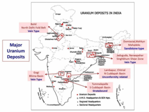
Statement 2 is correct. Jaduguda in Singhbhum Thrust Belt (in the state of Jharkhand, formerly part of Bihar) is the first uranium deposit to be discovered. (Hence statement 2 is correct).
Statement 3 is incorrect. Kazakhstan produces the largest share of uranium from mines (43% of world supply from mines in 2022), followed by Canada (13%) and Australia (12%). The Chu-Sarysu basin in central Kazakhstan alone accounts for over half of the country’s known uranium resources. The largest viable deposits of Uranium are found in Australia, Kazakhstan, and Canada. Olympic Dam and the Ranger mine in south are important mines in Australia. High-grade deposits are only found in the Athabasca Basin region of Canada.
Cigar Lake, McArthur River basin in Canada are other important uranium mining sites.
 Incorrect
Solution (b)
Explanation:
India has huge reserves of atomic minerals. Uranium and Thorium are the main atomic minerals. Thorium is derived from monazite which contains 10 percent thoria and 0.3 percent Urania.
Statement 1 is incorrect. India has the largest deposits of Thorium in the world and is trying hard to get on to the third stage of nuclear fuel consumption in order to get self-reliant in the nuclear fuel supply.
India produces about 2 percent of the world’s uranium. The total reserves of uranium are estimated at 30,480 tonnes. In India, Uranium deposits occur in Crystalline rocks.
Statement 2 is correct. Jaduguda in Singhbhum Thrust Belt (in the state of Jharkhand, formerly part of Bihar) is the first uranium deposit to be discovered. (Hence statement 2 is correct).
Statement 3 is incorrect. Kazakhstan produces the largest share of uranium from mines (43% of world supply from mines in 2022), followed by Canada (13%) and Australia (12%). The Chu-Sarysu basin in central Kazakhstan alone accounts for over half of the country’s known uranium resources. The largest viable deposits of Uranium are found in Australia, Kazakhstan, and Canada. Olympic Dam and the Ranger mine in south are important mines in Australia. High-grade deposits are only found in the Athabasca Basin region of Canada.
Cigar Lake, McArthur River basin in Canada are other important uranium mining sites.
-
Question 21 of 35
21. Question
Exercise INDRA is conducted between?
Correct
Solution (a)
Context:
- India and Russia have commenced a six-day naval exercise, ‘Indra’, off the coast of Chennai, involving sophisticated maritime drills and live weapon firings. In this context, a question about the exercise can be asked by UPSC.
Explanation:
- Exercise INDRA is an India – Russia bilateral naval exercise. Since its inception in 2003, Exercise Indra has epitomised the long-term strategic relationship between the Indian and Russian navies. The exercise has evolved into a symbol of maritime cooperation, showcasing the two nations’ commitment to enhancing naval interoperability and operational synergy. INDRA 2025 is the 14th edition of the exercise. The exercise is being conducted in two phases: Harbour phase at Chennai and Sea phase in the Bay of Bengal. Hence, option a is the correct answer.
Incorrect
Solution (a)
Context:
- India and Russia have commenced a six-day naval exercise, ‘Indra’, off the coast of Chennai, involving sophisticated maritime drills and live weapon firings. In this context, a question about the exercise can be asked by UPSC.
Explanation:
- Exercise INDRA is an India – Russia bilateral naval exercise. Since its inception in 2003, Exercise Indra has epitomised the long-term strategic relationship between the Indian and Russian navies. The exercise has evolved into a symbol of maritime cooperation, showcasing the two nations’ commitment to enhancing naval interoperability and operational synergy. INDRA 2025 is the 14th edition of the exercise. The exercise is being conducted in two phases: Harbour phase at Chennai and Sea phase in the Bay of Bengal. Hence, option a is the correct answer.
-
Question 22 of 35
22. Question
Cauvery Wildlife Sanctuary, seen in news recently is located in which state?
Correct
Solution (c)
Context:
- Recently, a bear died in Cauvery Wildlife Sanctuary after consuming explosive. In this context, a question about the location of the sanctuary can be asked by UPSC.
Explanation:
- Cauvery Wildlife Sanctuary is situated in the Chamarajanagar and Ramanagara districts of Karnataka, and it was established in 1987. The Cauvery River passes through its midst. It was established in 1987. The Sanctuary spans an area of 1027.535 square kilometers. It is home to mammals like elephant, wild boar, leopard, dhole, spotted deer, barking deer, four-horned antelope, chevrotain, common langur, bonnet macaque, honey badger (ratel), malabar giant squirrel, smooth-coated otter and Grizzled giant squirrel. Hence, option c is the correct answer.
Incorrect
Solution (c)
Context:
- Recently, a bear died in Cauvery Wildlife Sanctuary after consuming explosive. In this context, a question about the location of the sanctuary can be asked by UPSC.
Explanation:
- Cauvery Wildlife Sanctuary is situated in the Chamarajanagar and Ramanagara districts of Karnataka, and it was established in 1987. The Cauvery River passes through its midst. It was established in 1987. The Sanctuary spans an area of 1027.535 square kilometers. It is home to mammals like elephant, wild boar, leopard, dhole, spotted deer, barking deer, four-horned antelope, chevrotain, common langur, bonnet macaque, honey badger (ratel), malabar giant squirrel, smooth-coated otter and Grizzled giant squirrel. Hence, option c is the correct answer.
-
Question 23 of 35
23. Question
Consider the following statements about Dwarkadhish Temple:
- It is located in Gujarat.
- It is dedicated to Lord Krishna.
- It is one of the destinations along the Char Dham pilgrimage circuit.
- The temple is one of the 108 Divya Desams, or holy abodes of Vishnu, which are glorified by the Alwars.
How many of the above statements are correct?
Correct
Solution (d)
Context:
- A group of 300 Pakistani citizens of Indian origin, residing in Pakistan’s Sindh, recently visited the Dwarkadhish Temple, Devbhumi Dwarka in Gujarat and offered prayers. In this context, the temple becomes important from the perspective of UPSC.
Explanation:
- Located in Dwarka, Gujarat, India, the Dwarkadhish temple, also known as the Jagat Mandir, is a revered Hindu temple dedicated to Lord Krishna, who is referred to as Dwarkadhish, which means the ‘King of Dwarka’. This temple holds immense significance as it is one of the destinations along the Char Dham pilgrimage circuit, which includes the other pilgrimage sites, Badrinath, Rameshwaram, and Puri. Hence, statements 1, 2 and 3 are correct.
The temple is one of the 108 Divya Desams, or holy abodes of Vishnu, which are glorified by the Alwars, the 12th-century Tamil poet-saints. The temple is the 98th Divya Desam and is praised by four Alwars: Nammalwar, Thirumangai Alwar, Thirumalisai Alwar, and Periyalwar. The temple is also mentioned in the works of other Hindu saints and scholars, such as Adi Shankara, Ramanuja, Madhvacharya, and Narsinh Mehta. Hence, statement 4 is correct.
Incorrect
Solution (d)
Context:
- A group of 300 Pakistani citizens of Indian origin, residing in Pakistan’s Sindh, recently visited the Dwarkadhish Temple, Devbhumi Dwarka in Gujarat and offered prayers. In this context, the temple becomes important from the perspective of UPSC.
Explanation:
- Located in Dwarka, Gujarat, India, the Dwarkadhish temple, also known as the Jagat Mandir, is a revered Hindu temple dedicated to Lord Krishna, who is referred to as Dwarkadhish, which means the ‘King of Dwarka’. This temple holds immense significance as it is one of the destinations along the Char Dham pilgrimage circuit, which includes the other pilgrimage sites, Badrinath, Rameshwaram, and Puri. Hence, statements 1, 2 and 3 are correct.
The temple is one of the 108 Divya Desams, or holy abodes of Vishnu, which are glorified by the Alwars, the 12th-century Tamil poet-saints. The temple is the 98th Divya Desam and is praised by four Alwars: Nammalwar, Thirumangai Alwar, Thirumalisai Alwar, and Periyalwar. The temple is also mentioned in the works of other Hindu saints and scholars, such as Adi Shankara, Ramanuja, Madhvacharya, and Narsinh Mehta. Hence, statement 4 is correct.
-
Question 24 of 35
24. Question
Consider the following statements about Biomass Satellite Mission, which was in news recently:
- It will be launched jointly by NASA and ISRO.
- It aims to provide more accurate measurements of forest biomass to enhance our understanding of the carbon cycle.
- It will be placed in a sun-synchronous orbit (SSO) — a type of orbit in which satellites are in sync with the Sun.
- It is the first space satellite to carry a long-wavelength radar, called P-band.
How many of the above statements are correct?
Correct
Solution (c)
Context:
- The European Space Agency (ESA) is preparing to launch its newest space satellite, called Biomass. In this context, UPSC can ask a question about the mission.
Explanation:
- Biomass Satellite Mission will be launched by European Space Agency (ESA) to provide more accurate measurements of forest biomass to enhance our understanding of the carbon cycle. It will provide detailed 3D maps of the world’s most dense and remote tropical forests. The mission will lift off aboard the Vega C rocket from Europe’s spaceport in French Guiana. Hence, statement 1 is not correct and statement 2 is correct.
- It will be placed in a sun-synchronous orbit (SSO) — a type of orbit in which satellites are in sync with the Sun — at an altitude of around 666 km. It is the first space satellite to carry a long-wavelength radar, called P-band. This special radar means that it can scan deep through the forest canopy and collect information on different parts of the forest, such as tree trunks, branches, and stems, where trees store most of their carbon. Hence, statements 3 and 4 are correct.
Incorrect
Solution (c)
Context:
- The European Space Agency (ESA) is preparing to launch its newest space satellite, called Biomass. In this context, UPSC can ask a question about the mission.
Explanation:
- Biomass Satellite Mission will be launched by European Space Agency (ESA) to provide more accurate measurements of forest biomass to enhance our understanding of the carbon cycle. It will provide detailed 3D maps of the world’s most dense and remote tropical forests. The mission will lift off aboard the Vega C rocket from Europe’s spaceport in French Guiana. Hence, statement 1 is not correct and statement 2 is correct.
- It will be placed in a sun-synchronous orbit (SSO) — a type of orbit in which satellites are in sync with the Sun — at an altitude of around 666 km. It is the first space satellite to carry a long-wavelength radar, called P-band. This special radar means that it can scan deep through the forest canopy and collect information on different parts of the forest, such as tree trunks, branches, and stems, where trees store most of their carbon. Hence, statements 3 and 4 are correct.
-
Question 25 of 35
25. Question
The ‘Technology and Innovation Report’ was recently released by?
Correct
Solution (a)
Context:
- India has been ranked 10th in the world with significant private investments in Artificial Intelligence (AI) in 2023, according to the 2025 Technology and Innovation Report. In this context, a question can be asked by UPSC about the report.
Explanation:
- The ‘Technology and Innovation Report’ was released by the UN Conference on Trade and Development (UNCTAD). It seeks to address issues in science, technology and innovation that are topical and important for developing countries in a comprehensive way with an emphasis on policy-relevant analysis and conclusions. The 2025 edition of the report, entitled: Inclusive artificial intelligence for development, aims to guide policymakers through the complex Artificial Intelligence (AI) landscape and support them in designing science, technology and innovation policies that foster inclusive and equitable technological progress. Hence, option a is the correct answer.
Incorrect
Solution (a)
Context:
- India has been ranked 10th in the world with significant private investments in Artificial Intelligence (AI) in 2023, according to the 2025 Technology and Innovation Report. In this context, a question can be asked by UPSC about the report.
Explanation:
- The ‘Technology and Innovation Report’ was released by the UN Conference on Trade and Development (UNCTAD). It seeks to address issues in science, technology and innovation that are topical and important for developing countries in a comprehensive way with an emphasis on policy-relevant analysis and conclusions. The 2025 edition of the report, entitled: Inclusive artificial intelligence for development, aims to guide policymakers through the complex Artificial Intelligence (AI) landscape and support them in designing science, technology and innovation policies that foster inclusive and equitable technological progress. Hence, option a is the correct answer.
-
Question 26 of 35
26. Question
World Health Day is observed every year on?
Correct
Solution (c)
Context:
- Every year on April 7, World Health Day is observed to increase global awareness of a varied range of health-related concerns. In this context, a question can be asked about the day by UPSC.
Explanation:
World Health Day is observed on April 07 every year. This day marks the anniversary of the founding of the World Health Organization (WHO) in 1948 and has been celebrated since 1950. Each year, World Health Day is used as an opportunity to draw attention to a specific health topic that affects people all over the world. By emphasizing one particular theme every year, World Health Day encourages governments, healthcare organisations, and individuals to work collectively toward improving health standards and access to healthcare. The theme for World Health Day 2025 is ‘Healthy beginnings, hopeful futures.’ Hence, option c is the correct answer.
Incorrect
Solution (c)
Context:
- Every year on April 7, World Health Day is observed to increase global awareness of a varied range of health-related concerns. In this context, a question can be asked about the day by UPSC.
Explanation:
World Health Day is observed on April 07 every year. This day marks the anniversary of the founding of the World Health Organization (WHO) in 1948 and has been celebrated since 1950. Each year, World Health Day is used as an opportunity to draw attention to a specific health topic that affects people all over the world. By emphasizing one particular theme every year, World Health Day encourages governments, healthcare organisations, and individuals to work collectively toward improving health standards and access to healthcare. The theme for World Health Day 2025 is ‘Healthy beginnings, hopeful futures.’ Hence, option c is the correct answer.
-
Question 27 of 35
27. Question
Consider the following statements about Dudhwa Tiger Reserve:
- It is located on the Indo-Nepal border in the state of Uttarakhand.
- The reserve includes Dudhwa National Park, Kishanpur Wildlife Sanctuary and Katarniaghat Wildlife Sanctuary.
- It lies within the Tarai-Bhabar zone of the Upper Gangetic Plains Biogeographic Province.
Which of the above statements are correct?
Correct
Solution (c)
Context:
- Recently, a rare long-snouted vine snake (Ahaetulla longirostris) was rediscovered in the Dudhwa Tiger Reserve, Uttar Pradesh, during a rhino release operation in the Palia Kheri division. In this context, a question can be asked about the tiger reserve by UPSC.
Explanation:
-
- Dudhwa Tiger Reserve is located on the Indo-Nepal border in the Lakhimpur Kheri district, Uttar Pradesh. It features North Indian Moist Deciduous Forests, dominated by Sal trees (Shorea robusta). Major Mammals here include Tiger, Leopard (Guldar), Fishing cat, Langur, Jackal, Civet, Mongoose, etc. Hence, statement 1 is not correct.
- The reserve includes Dudhwa National Park, Kishanpur Wildlife Sanctuary, Katarniaghat Wildlife Sanctuary, and forest areas of North Kheri, South Kheri, and Shahjahanpur. It lies within the Tarai-Bhabar zone of the Upper Gangetic Plains Biogeographic Province. Major rivers in the region include Sharda river, Geruwa river, Suheli river and Mohana river. Hence, statements 2 and 3 are correct.
Incorrect
Solution (c)
Context:
- Recently, a rare long-snouted vine snake (Ahaetulla longirostris) was rediscovered in the Dudhwa Tiger Reserve, Uttar Pradesh, during a rhino release operation in the Palia Kheri division. In this context, a question can be asked about the tiger reserve by UPSC.
Explanation:
-
- Dudhwa Tiger Reserve is located on the Indo-Nepal border in the Lakhimpur Kheri district, Uttar Pradesh. It features North Indian Moist Deciduous Forests, dominated by Sal trees (Shorea robusta). Major Mammals here include Tiger, Leopard (Guldar), Fishing cat, Langur, Jackal, Civet, Mongoose, etc. Hence, statement 1 is not correct.
- The reserve includes Dudhwa National Park, Kishanpur Wildlife Sanctuary, Katarniaghat Wildlife Sanctuary, and forest areas of North Kheri, South Kheri, and Shahjahanpur. It lies within the Tarai-Bhabar zone of the Upper Gangetic Plains Biogeographic Province. Major rivers in the region include Sharda river, Geruwa river, Suheli river and Mohana river. Hence, statements 2 and 3 are correct.
-
Question 28 of 35
28. Question
Consider the following statements about Soyuz spacecraft, seen in news recently:
- The Soyuz spacecraft was jointly built by JAXA (Japan Aerospace Exploration Agency) and NASA (National Aeronautics and Space Administration).
- The Soyuz programme is the longest operational human spacecraft programme in the history of space exploration.
- A Soyuz vehicle can carry up to ten astronauts to space.
Which of the above statements are INCORRECT?
Correct
Solution (b)
Context:
- A Soyuz spacecraft, adorned to commemorate the 80th anniversary of World War II’s conclusion, departed from Kazakhstan’s Baikonur Cosmodrome recently, transporting an American and two Russians to the International Space Station (ISS). In this context, a question about the Soyuz spacecraft and mission can be asked by UPSC.
Explanation:
- The Soyuz spacecraft is a Russian (formerly Soviet) spacecraft that has been used since the 1960s to transport astronauts and cosmonauts to and from space. Soyuz means “union” in Russian. Although they were conceived by the Soviet Union at the start of the sixties, the Soyuz spacecraft are still used today, but with important modifications. Hence, statement 1 is INCORRECT.
- The Soyuz programme is the longest operational human spacecraft programme in the history of space exploration. The first crewed flight into space was on 23 April 1967. It has served mainly as a crew ferry to and from Earth-orbiting space stations, specifically the Salyut stations, Mir, and the International Space Station (ISS). The Soyuz vehicles are launched by Russian rockets of the same name, which have already had over 1680 successful launches in total, including satellites and manned spacecraft. Hence, statement 2 is correct.
- A Soyuz vehicle can carry up to three astronauts. A Soyuz is made up of three modules: the service, the orbital, and the re-entry modules. The orbital module (the “tip” of the spacecraft) carries the equipment necessary to dock with the International Space Station. The service module (the lower part) transports, among other things, telecommunications and altitude control equipment and the coupling of the solar panels. The descent module (in the middle) is where the astronauts travel, and it is the only section that re-enters the atmosphere – the orbital module breaks up during re-entry. Hence, statement 3 is INCORRECT.
Incorrect
Solution (b)
Context:
- A Soyuz spacecraft, adorned to commemorate the 80th anniversary of World War II’s conclusion, departed from Kazakhstan’s Baikonur Cosmodrome recently, transporting an American and two Russians to the International Space Station (ISS). In this context, a question about the Soyuz spacecraft and mission can be asked by UPSC.
Explanation:
- The Soyuz spacecraft is a Russian (formerly Soviet) spacecraft that has been used since the 1960s to transport astronauts and cosmonauts to and from space. Soyuz means “union” in Russian. Although they were conceived by the Soviet Union at the start of the sixties, the Soyuz spacecraft are still used today, but with important modifications. Hence, statement 1 is INCORRECT.
- The Soyuz programme is the longest operational human spacecraft programme in the history of space exploration. The first crewed flight into space was on 23 April 1967. It has served mainly as a crew ferry to and from Earth-orbiting space stations, specifically the Salyut stations, Mir, and the International Space Station (ISS). The Soyuz vehicles are launched by Russian rockets of the same name, which have already had over 1680 successful launches in total, including satellites and manned spacecraft. Hence, statement 2 is correct.
- A Soyuz vehicle can carry up to three astronauts. A Soyuz is made up of three modules: the service, the orbital, and the re-entry modules. The orbital module (the “tip” of the spacecraft) carries the equipment necessary to dock with the International Space Station. The service module (the lower part) transports, among other things, telecommunications and altitude control equipment and the coupling of the solar panels. The descent module (in the middle) is where the astronauts travel, and it is the only section that re-enters the atmosphere – the orbital module breaks up during re-entry. Hence, statement 3 is INCORRECT.
-
Question 29 of 35
29. Question
Consider the following statements about the term ‘De-Extinction’ seen in news recently:
- De-extinction refers to the scientific process of reviving extinct species by using their genetic material, often through gene editing and cloning techniques.
- It involves reconstructing the genome of an extinct species and modifying the DNA of a closely related living organism to resemble the extinct one.
Which of the above statements is/are correct?
Correct
Solution (c)
Context:
- A US-based bioscience company, Colossal Biosciences, has recently made headlines by announcing the birth of three genetically modified grey wolf pups. In this context, a question can be asked about the term ‘De-Extinction’ which is associated with it.
Explanation:
- De-extinction refers to the scientific process of reviving extinct species by using their genetic material, often through gene editing and cloning techniques. It involves reconstructing the genome of an extinct species and modifying the DNA of a closely related living organism to resemble the extinct one. Hence, statements 1 and 2 are correct.
- The de-extinction process followed by Colossal involved the following steps:
- DNA extraction: Scientists obtained DNA from two ancient dire wolf specimens: a 13,000-year-old tooth and a 72,000-year-old skull. The petrous bone from the skull, known for its preserved DNA, was crucial in this process.
- Genome reconstruction: The DNA was sequenced to recreate the complete genome of the dire wolf. This was then compared with genomes from closely related canids like coyotes, jackals, dholes, and particularly, grey wolves, which were found to share 99.5% of their DNA with dire wolves.
- Gene editing: Using gene editing tools, scientists made 20 unique changes to 14 genes in the grey wolf genome.
- Surrogacy and Birth: The genetically modified embryos were implanted into surrogate dog mothers, leading to the birth of the pups.
Incorrect
Solution (c)
Context:
- A US-based bioscience company, Colossal Biosciences, has recently made headlines by announcing the birth of three genetically modified grey wolf pups. In this context, a question can be asked about the term ‘De-Extinction’ which is associated with it.
Explanation:
- De-extinction refers to the scientific process of reviving extinct species by using their genetic material, often through gene editing and cloning techniques. It involves reconstructing the genome of an extinct species and modifying the DNA of a closely related living organism to resemble the extinct one. Hence, statements 1 and 2 are correct.
- The de-extinction process followed by Colossal involved the following steps:
- DNA extraction: Scientists obtained DNA from two ancient dire wolf specimens: a 13,000-year-old tooth and a 72,000-year-old skull. The petrous bone from the skull, known for its preserved DNA, was crucial in this process.
- Genome reconstruction: The DNA was sequenced to recreate the complete genome of the dire wolf. This was then compared with genomes from closely related canids like coyotes, jackals, dholes, and particularly, grey wolves, which were found to share 99.5% of their DNA with dire wolves.
- Gene editing: Using gene editing tools, scientists made 20 unique changes to 14 genes in the grey wolf genome.
- Surrogacy and Birth: The genetically modified embryos were implanted into surrogate dog mothers, leading to the birth of the pups.
-
Question 30 of 35
30. Question
Consider the following statements about Electronics Components Manufacturing Scheme:
- It is the first dedicated production-linked incentive (PLI) scheme to promote the manufacturing of select passive electronic components.
- Employment generation will be a mandatory requirement for all applicants, including both component manufacturers and capital equipment producers.
Which of the above statements is/are correct?
Correct
Solution (c)
Context:
- The Ministry of Electronics and Information Technology (MeitY) recently notified the Electronics Components Manufacturing Scheme, marking a significant step towards strengthening India’s position as a global hub for electronics manufacturing. In this context, a question can be asked by UPSC about the scheme.
Explanation:
- The Electronics Components Manufacturing Scheme is the first dedicated production-linked incentive (PLI) scheme to promote the manufacturing of select passive electronic components, including resistors, capacitors, speakers, microphones, special ceramics, relays, switches, and connectors. Hence, statement 1 is correct.
- Employment generation will be a mandatory requirement for all applicants, including both component manufacturers and capital equipment producers. Thus, the scheme not only boosts manufacturing but also creates skilled jobs. This scheme has a tenure of six years, with a one-year gestation period. Hence, statement 2 is correct.
Incorrect
Solution (c)
Context:
- The Ministry of Electronics and Information Technology (MeitY) recently notified the Electronics Components Manufacturing Scheme, marking a significant step towards strengthening India’s position as a global hub for electronics manufacturing. In this context, a question can be asked by UPSC about the scheme.
Explanation:
- The Electronics Components Manufacturing Scheme is the first dedicated production-linked incentive (PLI) scheme to promote the manufacturing of select passive electronic components, including resistors, capacitors, speakers, microphones, special ceramics, relays, switches, and connectors. Hence, statement 1 is correct.
- Employment generation will be a mandatory requirement for all applicants, including both component manufacturers and capital equipment producers. Thus, the scheme not only boosts manufacturing but also creates skilled jobs. This scheme has a tenure of six years, with a one-year gestation period. Hence, statement 2 is correct.
-
Question 31 of 35
31. Question
Passage
It is a pity that India, which has been at the forefront of fighting for the TRIPS waiver, is at risk of being edged out. This is a failure of India’s economic diplomacy. However, it would be inappropriate to lay all the blame at the door of Indian diplomacy. Several failures domestically have undesirably impacted India’s global campaign. First, during the entire pandemic, India rarely made use of the existing flexibilities under the Indian Patent Act, such as compulsory licenses (CL), which are consistent with the TRIPS agreement, to increase the supply of Covid-19 medical products despite being nudged by the judiciary to do so. On the contrary, during the peak of the second Covid wave in May last year, the central government filed an affidavit in the Supreme Court stating that the main constraint in boosting the production of key drugs is the unavailability of raw materials, not IP-related legal hurdles. This stand completely contradicted India’s argument internationally that views IP as an obstacle to augmenting the supply of Covid-19 medical products.
Q.31) Which of the following statements best reflects the critical message of the passage?
Correct
Solution (b)
Explanation
Statement (a) is incorrect. Refer to the line, “India rarely made use of existing flexibilities under the Indian Patent Act. It is not mentioned that none of the flexibilities were used by India. Compulsory Licences (CL) is one such flexibility which is consistent with the TRIPS agreement and was not used to increase the supply of Covid-19 medical products.” The passage only makes a reference to limited use of flexibilities under the Indian Patent Act during pandemic which was a specific public health emergency. This cannot be generalised to say that India does not use these flexibilities under all public health emergencies. Hence, this answer option is incorrect.
Statement (b) is correct. The entire passage revolves around the fact that India faces a risk of getting marginalised in an attempt to gain a waiver of TRIPS. This has happened partly because of the failure of India’s economic diplomacy and some domestic failures, like the affidavit of the Central government in the Supreme Court which states that unavailability of the raw material is the main constraint in boosting production of key drugs. Internationally, India made the argument that Intellectual Property is an obstacle in augmenting the supply of Covid19 medical products.
Statement (c) is incorrect. Refer to the line, “However, it would be inappropriate to lay all the blame at the door of Indian diplomacy.” This clearly states that not all the blame can be put on Indian diplomacy. Several other factors like domestic failures are responsible. Hence, this option can be outrightly rejected.
Statement (d) is incorrect as option (a) is incorrect.
Incorrect
Solution (b)
Explanation
Statement (a) is incorrect. Refer to the line, “India rarely made use of existing flexibilities under the Indian Patent Act. It is not mentioned that none of the flexibilities were used by India. Compulsory Licences (CL) is one such flexibility which is consistent with the TRIPS agreement and was not used to increase the supply of Covid-19 medical products.” The passage only makes a reference to limited use of flexibilities under the Indian Patent Act during pandemic which was a specific public health emergency. This cannot be generalised to say that India does not use these flexibilities under all public health emergencies. Hence, this answer option is incorrect.
Statement (b) is correct. The entire passage revolves around the fact that India faces a risk of getting marginalised in an attempt to gain a waiver of TRIPS. This has happened partly because of the failure of India’s economic diplomacy and some domestic failures, like the affidavit of the Central government in the Supreme Court which states that unavailability of the raw material is the main constraint in boosting production of key drugs. Internationally, India made the argument that Intellectual Property is an obstacle in augmenting the supply of Covid19 medical products.
Statement (c) is incorrect. Refer to the line, “However, it would be inappropriate to lay all the blame at the door of Indian diplomacy.” This clearly states that not all the blame can be put on Indian diplomacy. Several other factors like domestic failures are responsible. Hence, this option can be outrightly rejected.
Statement (d) is incorrect as option (a) is incorrect.
-
Question 32 of 35
32. Question
Direction for the following 1 (one) item: Read the information given below and answer the 1 (one) item that follow.
Seven people J, K, L, M, N, O and P are standing in a queue facing north, but not necessarily in the same order. L sits second from one of the extreme ends of the row. Number of people to the left of M is the same as the number of people to the right of M. N sits fourth to the left of O. K sits on the immediate right of P. Neither P nor J sits at any of the extreme ends of the row.
Q.32) What is the position of P with respect to J?
Correct
Solution (b)
Explanation
L sits second from one of the extreme ends of the row.
Number of people to the left of M is the same as the number of people to the right of M. Also, N sits fourth to the left of O. So, the possible cases are:
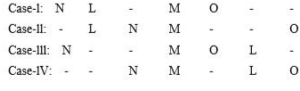
K sits on the immediate right of P. And the remaining place is taken by J.
Case-I: N L J M O P K
Case-II: J L N M P K O
Case-III: N P K M O L J
Case-IV: P K N M J L O
But neither P nor J sits at any of the extreme ends of the row. So, case-ll, case-lll and case-lV can be eliminated. Hence case-l is the final arrangement.
Final arrangement:
N L J M O P
P is 3rd to the right of J
Incorrect
Solution (b)
Explanation
L sits second from one of the extreme ends of the row.
Number of people to the left of M is the same as the number of people to the right of M. Also, N sits fourth to the left of O. So, the possible cases are:
K sits on the immediate right of P. And the remaining place is taken by J.
Case-I: N L J M O P K
Case-II: J L N M P K O
Case-III: N P K M O L J
Case-IV: P K N M J L O
But neither P nor J sits at any of the extreme ends of the row. So, case-ll, case-lll and case-lV can be eliminated. Hence case-l is the final arrangement.
Final arrangement:
N L J M O P
P is 3rd to the right of J
-
Question 33 of 35
33. Question
Directions for the following 1(one) item: Read the information given below carefully and answer the 1(one) items that follow.
In a school tournament, 28 students participated in cricket, 34 participated in hockey, and 30 participated in basketball. Moreover, it’s known that 16 students participated in both cricket and hockey, 12 participated in both cricket and basketball, and 15 participated in both basketball and hockey. While, 7 participated in all the three sports.
Q.33) How many students are there in all?
Correct
Solution (c)
Explanation
Total number of students = 7 + 5 + 7 + 9 + 8 + 10 + 10 = 56 Hence, option (c) is the correct answer.
Incorrect
Solution (c)
Explanation
Total number of students = 7 + 5 + 7 + 9 + 8 + 10 + 10 = 56 Hence, option (c) is the correct answer.
-
Question 34 of 35
34. Question
Passage
In many corners of the world, there is a growing belief that leaders, companies, and institutions are not accountable to the people they are supposed to serve. There is also powerful new evidence that our leaders are failing to address one problem at the heart of these corrosive trends: extreme and growing economic inequality. While there are straightforward ways the world’s leaders—inside and outside of government— could act together to enhance transparency and accountability, two big developments emphasize the daunting scale of the task at hand. First underscores that the wealth gap is driven primarily by public policy choices and that the growth of that gap is accelerating and second, sweeping federal tax reform passed in the United States will accelerate the growth of that wealth gap dramatically. In recent years, we have seen powerful results when we make data and evidence accessible and analyze it, and when citizens mobilize to make their voices heard and hold leaders accountable.
Q.34) Which one of the following statements best reflects the crux of the passage?
Correct
Solution (c)
Explanation
Option (a) is incorrect. The passage mentions that “There is also powerful new evidence that our leaders are failing to address one problem at the heart of these corrosive trends.” However, it does not mention anything related to the crunch of able leaders in governance skills. Therefore, this option cannot be the crux of the passage.
Option (b) is incorrect. According to the passage, “second, sweeping federal tax reform passed in the United States will accelerate the growth of that wealth gap dramatically.” This implies that the growing wealth gap will increase due to tax reforms.
Option (c) is correct. The line, “data and evidence accessible and analyze it, and when citizens mobilize to make their voices heard and hold leaders accountable.”, reflects that by using the data and evidence the citizens could make the leaders accountable.
Option (d) is incorrect. The passage mentions economic inequality as a challenge, but not as the biggest one. So, this statement cannot be the crux of the given passage.
Incorrect
Solution (c)
Explanation
Option (a) is incorrect. The passage mentions that “There is also powerful new evidence that our leaders are failing to address one problem at the heart of these corrosive trends.” However, it does not mention anything related to the crunch of able leaders in governance skills. Therefore, this option cannot be the crux of the passage.
Option (b) is incorrect. According to the passage, “second, sweeping federal tax reform passed in the United States will accelerate the growth of that wealth gap dramatically.” This implies that the growing wealth gap will increase due to tax reforms.
Option (c) is correct. The line, “data and evidence accessible and analyze it, and when citizens mobilize to make their voices heard and hold leaders accountable.”, reflects that by using the data and evidence the citizens could make the leaders accountable.
Option (d) is incorrect. The passage mentions economic inequality as a challenge, but not as the biggest one. So, this statement cannot be the crux of the given passage.
-
Question 35 of 35
35. Question
One pendulum ticks 57 times in 58 seconds and another 608 times in 609 seconds. If they started simultaneously, find the time after which they will tick together.
Correct
Solution (c)
Explanation
Time between two consecutive ticks:
58/57 seconds and 609/608 seconds
Therefore, Required time = LCM of 58/57 and 609/608 = LCM of 58 and 609 / HCF of 57 and 608 = 1218 / 19 seconds
Incorrect
Solution (c)
Explanation
Time between two consecutive ticks:
58/57 seconds and 609/608 seconds
Therefore, Required time = LCM of 58/57 and 609/608 = LCM of 58 and 609 / HCF of 57 and 608 = 1218 / 19 seconds
All the Best
IASbaba