TLP-UPSC Mains Answer Writing

SYNOPSIS [21st July,2020] Day 36: IASbaba’s TLP (Phase 2): UPSC Mains Answer Writing (General Studies)
1. What are shields? How are they formed? Examine the distribution of shields in the world.
ढाल क्या हैं? वे कैसे बनते हैं? दुनिया में ढाल के वितरण की जाँच करें।
Demand of the question:
It expects students to explain about the shields and their formation process. It also expects students to present clear data about the distribution of shields in the world.
Introduction:
A shield is a large area of exposed Precambrian crystalline igneous and high-grade metamorphic rocks that form tectonically stable areas. These rocks are older than 570 million years and sometimes date back 2 to 3.5 billion years.
Body:
Shields have been little affected by tectonic events following the end of the Precambrian, and are relatively flat regions where mountain building, faulting, and other tectonic processes are minor, compared with the activity at their margins and between tectonic plates.
Formation of Shields:
- A shield is that part of the continental crust in which these usually Precambrian basement rocks crop out extensively at the surface.
- Shields themselves can be very complex: they consist of vast areas of granitic or granodioritic gneisses, usually of tonalitic composition, and they also contain belts of sedimentary rocks, often surrounded by low-grade volcano-sedimentary sequences, or greenstone belts.
- Shield form over the years through processes such as plate tectonics, erosion and glaciations. Plate tectonics refers to the movement and collision of the Earth’s outer crust. When these crustal plates collide they may weld together, forming larger landmasses.
- These rocks are frequently metamorphosed greenschist, amphibolite, and granulite facies. It is estimated that over 50% of Earth’s shields surface is made up of gneiss.
Distribution of shields in the world:
- Shield areas in general are regarded as continental nuclei, the observation often being made that most continental shields are bordered by belts of folded rocks of post-Precambrian age. Following figure 1 represents distribution of shields in the world.
- Shields, occur on each of the continents. One of the best known is the Canadian Shield, which extends from Lake Superior on the south to the Arctic Islands on the north, and from western Canada eastward, to include most of Greenland.
- In South America, the principal shield area is called the Amazonian Shield. It occupies much of the eastern bulge of the continent. Smaller areas of Precambrian rocks to the north and south of the Amazonian Shield are designated the Guiana and Platian shields, respectively.
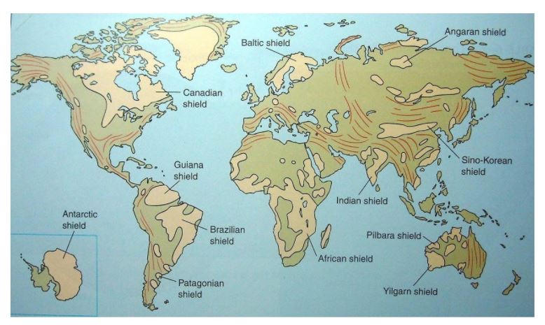
figure 1
- The Baltic, or Fennoscandian, Shield occupies most of Finland and Sweden, as well as eastern Norway. It is bordered on the west by the Caledonian Belt of younger, folded rocks.
- The African Shield, sometimes called the Ethiopian Shield, extends eastward to include western Saudi Arabia and the eastern half of Madagascar.
- The southern two-thirds of peninsular India, most of the western half of Australia, and the eastern segment of Antarctica are also areas of continental shields. These areas of Precambrian rocks are termed, appropriately, the Indian Shield, the Australian Shield, and the Antarctic Shield.
- In Asia the name Angaran Shield is applied to a large stable block bounded by the Lena and Yenisey rivers on the east and west and by the Arctic Ocean and Lake Baikal to the north and south.
Based on their location Shields are also known to provide other economic benefits like:
- Dharwad Shield with laterite soil has promoted development of building materials like bricks.
- Baltic shield: with glacier retreat shield depressions have turned into lakes supporting inland transport in Sweden and Finland.
Conclusion:
We have seen that based on their location shields have different economic significance. Hence, it becomes important to understand more about the characteristics of shields so that their true potential can be used to achieve sustainable development.
2. How do geographic features of a place aid to pollution? Explain with the help of suitable examples.
किसी स्थान की भौगोलिक विशेषताएं प्रदूषण कैसे बढाती हैं? उपयुक्त उदाहरणों की सहायता से समझाएँ।
Demand of the question:
It expects students to put a clear picture of how do geographic features of a place aid to pollution with relative examples.
Introduction:
Pollution is the introduction of harmful materials into the environment. Pollution can be caused by the natural as well as human factors. Geographical features of a place aid pollution in natural as well as human related ways.
Body:
Geographical features aid to Pollution:
- Mountains: Mountains stop the horizontal transport of smog, or divert it in another direction, unless the wind is strong enough to blow over the mountain.
- For instance, Delhi-NCR lies to the north-east of the Thar Desert, to the north-west of the central plains and to the south-west of the Himalayas.
- As winds arrive from the coasts, bringing with them pollutants picked up along the way, they get ‘trapped’ right before the Himalayas.
- Wind direction: Winds originating from over the desert landscapes gets trapped inside two parallel mountainous system. Hence, being not able to pass from one direction to other it settles down over the region between two mountains hence, it aids the pollution.
- The region becomes a “bowl” that collects pollutants, with only a narrow outlet for it to escape.
- For instance, The air pressure pushes from one direction, and with the inability to escape quickly in the other, the particulate matter accumulates over the northern plains i.e. the entire expanse between Punjab in the west to West Bengal in the east, including Delhi.
- Distant away from coastal regions: The most fundamental parameter that impacts air quality is the speed and direction of wind. The wind carries the air pollutants away from it. Winds origination from coastal areas carry away with them pollutants.
- Resulting in freeing the nearby area from pollution.
- For example, Chennai has the third highest number of automobiles in India, next only to Delhi-NCR and Bangalore. But being a coastal city Chennai doesn’t experiences same problem of pollution as that of the Delhi-NCR.
- Cropping pattern and cycles: Depending on the geographical features farming practises are established. As we know in the plains of Punjab wheat crop is harvested during the times of winter. Hence, stubble burning takes place. It aggravates the pollution in adjoining Northern Indian regions.
- As the Cropping pattern and cycle is based on the geographical features it aids the pollution. As to intensify the production use of pesticides and fertilizers takes place.
- Excess amount of pesticide and fertilizer in fresh water gives rise to water pollution.
- River water moves slowly in the plain areas hence, it is likely possible that the pollutants may accumulate in to the water and result in pollution of major rivers. e.g. Han River in Wuhan.
- Also, many of the industrial areas are also established based on the availability of the required raw material in the surrounding area and other factors. As concentration of the industries takes place in one particular area due to geographical factors it helps to aggravate the pollution problem.
- For instance, brick kilns industry’s concentration in one particular area can add up to air pollution.
- Land Pollution: Many of the same pollutants that foul the water also harm the land. Mining industries located in specific geographic regions due to their need of raw materials, sometimes leaves the soil contaminated with dangerous chemicals.
Actions to combat Geographically aided pollution:
- Countries around the world are tackling various forms of pollution. China, for example, is making strides in cleaning up smog-choked skies from years of rapid industrial expansion, partly by closing or cancelling coal-fired power plants.
- Increased use of clean renewable energy: As burning fossil fuels contribute major chunk of pollution. Shifting to clean and renewable energy sources is the best way to reduce the intensity of pollution. For example, India is aiming to produce 175GW of renewable energy by 2022.
- Introducing the new technological innovations such as smog towers installed in Delhi-NCR.
- Integrated waste management & circular economy policy can be implemented.
- Efforts to combat pollution will contribute to SDG 3 (good health and well-being). SDG target 7.2 on access to clean energy in the home, SDG target 11.6 on air quality in cities, SDG target 11.2 on access to sustainable transport and SDG 13 (climate action), as well as the goals of the Paris Agreement on climate .
Conclusion:
As we have understood that geographical feature aids the pollution and pollution is emerged as one of the major global threats; a proper, clean and planned approach will help to reduce the impact of pollution and helps to achieve the clean & clear environment for the people.
3. What are ‘internet balloons’? Why was it in news recently? Discuss.
‘इंटरनेट गुब्बारे‘ क्या हैं? यह हाल ही में खबरों में क्यों था? चर्चा करें।
Demand of the question:
It expects students to discuss various perspectives of ‘internet balloons’ and present a logical arguments regarding its advantages and disadvantages.
Introduction:
Billions of people around the world are still without internet access. Loon is a network of balloons travelling on the edge of space, delivering connectivity to people in un-served and underserved communities around the world. In short, internet balloon is a device which provides internet connectivity while floating in the air.
Body:
Recently, A fleet of high-altitude balloons started delivering internet service to Kenya , extending online access to tens of thousands of people in the first-ever commercial deployment of the technology.
- The balloons, which hover about 12 miles up in the stratosphere — well above commercial airplanes — will initially provide a 4G LTE network connection to a nearly 31,000-square-mile area across central and western Kenya, including the capital, Nairobi.
- It is now being fast-tracked to help improve communications during the corona virus pandemic.
- Loon, a unit of Google’s parent company, Alphabet, launched 35 balloons to provide internet connectivity in Kenya.
Technology used in internet balloons:
- Delivering connectivity from balloons flying 20 km up in the stratosphere poses a unique set of engineering challenges. To expand connectivity to un-served and underserved areas around the world, Loon combines advancements in materials science, atmospheric modelling, machine learning, communications systems, and more.
- Loon balloons are designed and manufactured to endure the harsh conditions in the stratosphere, where winds can blow over 100 km/hr, and temperatures can drop as low as -90° C.
- Balloon made from sheets of polyethylene, each tennis court-sized balloon is built to last for well over 100 days before landing back on Earth in a controlled descent.
- Antennas transmit connectivity from ground stations, across a balloon mesh network, and back down to a user’s LTE phone. A user needs nothing more than a standard LTE phone to connect to a Loon balloon.
Advantages of Internet balloon:
- Internet balloon bills the service as a cost-effective solution to the difficult challenge of bringing internet access to people in underserved remote areas.
- This could be effective in scattered population regions, such as in Africa, where just over 28 percent of the continent’s 1.3 billion people were using the internet in 2019 — the lowest rate in any region worldwide — according to the International Telecommunication Union, a United Nations agency.
- It would be a cheaper solution than installing fibre optic cables or building mobile phone masts across the areas which contain jungles and mountains.
Disadvantages of Internet balloon:
- Coverage: Due to its lower height, its signals cover a relatively small area. As a result, many more balloon are needed in order to reach signals to every part of the area.
- Difficulty for aeroplanes: The Internet balloons float in the stratosphere. As aeroplanes too fly in the stratosphere, Internet balloons pose a serious threat of air disaster if not controlled neatly.
- Difficulty in Space Studies: The constellations of internet balloons will make it difficult to observe space objects, and to detect their signals.
Conclusion:
With its high end technology internet balloon can prove to be an essential solution to the problem of expanding internet to the every corner of the world. But, at the same time more improvement is needed in them to reduce their drawbacks and achieving the internet connectivity to all.


