Question Compilation, TLP-UPSC Mains Answer Writing

For Previous TLP (ARCHIVES) – CLICK HERE
SYNOPSIS [10th DECEMBER,2020] Day 52: IASbaba’s TLP (Phase 2): UPSC Mains Answer Writing (General Studies)
1. Discuss the physiographic features of shields and cratons. How do they get formed? Discuss.
Approach:
It expects aspirants to write about various physiographic features of shields and craton. Also write about how shields and cratons formed. You can also draw diagram for better illustration.
Introduction:
A craton is an old and stable part of the continental lithosphere, which consists of Earth’s two topmost layers, the crust and the uppermost mantle. A shield is a large area of exposed Precambrian crystalline igneous and high-grade metamorphic rocks that form tectonically stable areas.
Body:
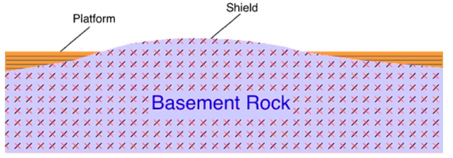
Cratons:
- Cratons have thick lithospheric roots. Mantle tomography shows that cratons are underlain by anomalously cold mantle corresponding to lithosphere more than twice the typical 100 km thickness of mature oceanic or non-cratonic, continental lithosphere. At that depth, craton roots extend into the asthenosphere. Craton lithosphere is distinctly different from oceanic lithosphere because cratons have a neutral or positive buoyancy, and a low intrinsic isopycnic density. This low density offsets density increases due to geothermal contraction and prevents the craton from sinking into the deep mantle. Cratonic lithosphere is much older than oceanic lithosphere—up to 4 billion years versus 180 million years.
- The process by which cratons were formed from early rock is called cratonization. The first large cratonic landmasses formed during the Archean eon. During the early Archean, Earth’s heat flow was nearly three times higher than it is today because of the greater concentration of radioactive isotopes and the residual heat from the Earth’s accretion. There was considerably greater tectonic and volcanic activity; the mantle was less viscous and the crust thinner. This resulted in rapid formation of oceanic crust at ridges and hot spots, and rapid recycling of oceanic crust at subduction zones. There are at least three hypotheses of how cratons have been formed: 1) surface crust was thickened by a rising plume of deep molten material, 2) successive subducting plates of oceanic lithosphere became lodged beneath a proto-craton in an under-plating process, 3) accretion from island arcs or continental fragments rafting together to thicken into a craton.
Shields:
- A shield is that part of the continental crust in which these usually Precambrian basement rocks crop out extensively at the surface. Shields themselves can be very complex: they consist of vast areas of granitic or granodioritic gneisses, usually of tonalitic composition, and they also contain belts of sedimentary rocks, often surrounded by low-grade volcano-sedimentary sequences, or greenstone belts. These rocks are frequently metamorphosed greenschist, amphibolite, and granulite facies. It is estimated that over 50% of Earth’s shields surface is made up of gneiss.
Conclusion:
Thus Craton comprising shields both form major geological features of earth. They help in understanding the process of formation of rocks and their period of formation.
Q 2. Examine the factors that lead to extremely arid conditions in the Atacama.
Approach:
It expects students to examine different factors like Subtropical high, Double rain shadow and Cold ocean current leads to arid conditions in Atacama. You can also draw diagram/map to explain it further.
Introduction:
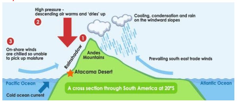
Atacama Desert extends from the west coast of Chile and spills over the bordering nations of Argentina, Peru, and Bolivia. While it’s not truly the driest place on the whole planet, it’s the driest hot desert on Earth, receiving less than 0.6 inches of rain on average the whole year.
Body:
The Atacama Desert can attribute its astoundingly low precipitation to a combination of several “drying” factors: the subtropical high, a double rain shadow, and the cold ocean current running up the west coast of South America. These factors work together to make an amazing synthesis of dry conditions that form the unique climate of the Atacama.
Subtropical high:
- The first factor, the subtropical high, is a global wind and pressure belt that can be found around 30 degrees North or South, right around where the Atacama Desert is. This pressure belt stretches around the world at this latitude and suppresses the formation of clouds by making it difficult for air to rise. Naturally, this creates a zone of low precipitation. Many areas around the world under the subtropical high have lower rainfall levels, but none quite as low as the Atacama. That’s because there are other influences at work here.
Double rain shadow:
- The second factor is the double rain shadow over the desert. A rain shadow is an area that receives less rainfall as a result of a nearby mountain chain. Oftentimes, a mountain will have a prevailing wind blowing into one side of it, and that receives a lot of rainfall because that wind pushes the moisture in the wind up the mountain, creating clouds and precipitation. Consequently, the other side of the mountain often has less rain because there’s much less moisture in the air. This phenomenon affects the Atacama Desert on two fronts: the Andes Mountains and the Chilean Coast Range. The desert is primarily on the leeward side of each mountain chain, which is where the rain shadow is for mountain ranges, further decreasing the amount of rain the desert gets.
Cold ocean current:
- The third major factor that keeps the Atacama Desert so dry is the cold ocean current that runs adjacent to the coast of South America. This cold current decreases the temperature of the surrounding air, making it unable to accumulate a good deal of moisture over the ocean (since cold air can’t “hold” as much moisture as hot air). Of course, this means that the desert doesn’t have much of a chance to receive moisture from the ocean next to it, making it even drier.
Conclusion:
Atacama Desert is an important desert to study because it encompasses many important aspects of climate. Not only this, but the desert impacts the well-being of the people that live in or around it. Understanding how the climate of the area came to be is important to understand how climate works, how it changes the environment, and how it impacts people in its environment.
Q 3. Why has the Aral Sea shrunk? Discuss.
Approach:
As the directive here is discuss, you have to cover various angles related to the topic. In the introduction you explain the location of Aral sea and then brief how it shrunk. In the main body part enlist the reasons and in brief give a way forward. Drawing a map to show the location of Aral sea or showing the extent of shrinking will be a value addition.
Introduction:
The Aral was an endorheic lake lying between Kazakhstan and Uzbekistan which began shrinking in the 1960s and had largely dried up by the 2010s. Today, the lake-which was called a sea due its sheer size and salinity-has reduced to a mere 25 per cent of its original size. The re-routing of Amu Darya river and Syr Darya river to give impetus to cotton production aggravated shrinking of the Aral Sea.
Body:
In the 1960s, the depth of the lake was 68 metres. Today, it is less than 10 metres. A relatively shallow water level spread across a large surface area has led to faster evaporation. This has caused over 90 per cent loss in the volume of water in the last six decades. Following are the major reasons for the shrunk:
- By establishing a program to promote agriculture and especially that of cotton, Soviet government led by Khrouchtchev in the 1950s deliberately deprived the Aral Sea of its two main sources of water income, which almost immediately led to less water arriving to the sea.
- Layered problems: The Aral Sea is a terminal lake with no outlets. As it lies in a rain-shadow region, the rate of evaporation far outweighs the rate of precipitation as an average annual rainfall in the nearby regions is nearly 100mm.
- The need to strike a balance between the river feed, precipitation, evaporation and seepage has made it difficult to ensure its survival. Any change in any of these four factors affects the quantity and quality of water, rapidly.
- Therefore, the reason of ongoing disaster lies beyond the northern region of Kaza-khstan and the Ustyurt Plateau region that includes the critical mass of the Aral Sea. Following figure 1 shows the drying up of the Aral sea.
- There has been an increase in the abstraction of groundwater throughout the basins of the two rivers. The water is pumped out at the upstream of the Amu Darya River that feeds the Silk Route towns—Bukhara, Samarkand and Tashkent in Uzbekistan. The outflow from these towns does not balance the inflow.
- Increase in evaporation, coupled with reduced groundwater inflow and precipitation, has further led to salinisation and the foaming of water.
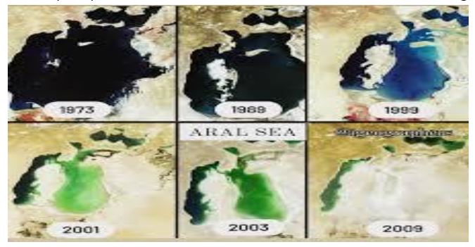
Figure 1: Drying up of the Aral sea
- The south-west edge of the Aral Sea has eroded, forming large canyons along the Ustyurt Plateau. These canyons were formed by a process of long-time erosion. The Ustyurt Plateau, which overlooks the western edge of the Aral Sea, is a clay and stony desert with an average elevation of 150 metres. In geological terms, it is called “Sarmatian limestones’ with separated edges leading to steep slopes.
- The Aral Sea catastrophe exemplifies the Anthropogenic era. This human-made disaster is affecting the ecosystem for more than five decades now.
- Yet, the current development paradigm is conveniently ignoring the long-term repercussions and is choosing the option of altering the water bodies to suit bigger and profitable agendas. The current state of the Aral Sea needs to be understood and its lessons be applied whenever we think of altering the course of any waterbody.
In 1993, Central Asian countries-Kazakhstan, Kyrgyzstan, Tajikistan, Turk-menistan and Uzbekistan-established the International Fund for Saving the Aral Sea to rehabilitate the affected region ecologically. The mission was to save the people living in Aral Sea basin by improving their living conditions.
Conclusion:
In 2005, the Kokaral Dam was built in a joint collaboration between the Kazakh government and the World Bank to restore the delta and the wetland region in Syr Darya River basin. However, these sporadic efforts are not enough to revive the basin spanning seven nations. A cross-country method needs to be put in place by owning collective responsibility. Because it may take many generations to revive the lost lake back to its original glory.
Q.4 Why is the Tibetan plateau called the roof of the world? How does the Tibetan
plateau affect the climate in the Indian subcontinent? Discuss.
Approach – It expects students to write about Tibetan plateau and how does Tibetan plateau affect the climate in the Indian subcontinent.
Introduction
Highest and largest plateau in the world and hence called the ‘roof of the world’. Formed due to collision of the Indo-Australian and Eurasian tectonic plates. It covers most of the Autonomous Tibetan Region, Qinghai Province of Western China, and a part of Ladakh in Jammu and Kashmir.
Body
Tibetan plateaus affecting on climate pattern in India Subcontinent:
- The Tibetan Plateau is an enormous block of highland acting as a formidable barrier. Due to its protruded height it receives 2-3°C more insolation than the neighbouring areas. The plateau affects the atmosphere in two ways: (a) as a mechanical barrier, and (b) as a high- level heat sources.
- At the beginning of June the subtropical jet stream is completely withdrawn from India and occupies a position along 40° N (to the north of Tibetan Plateau).The plateau accentuates the northward displacement of the jet stream. Hence the burst of monsoon in June is prompted by the Himalayas and not by the thermally induced low pressure cell over Tibet. (Tibetan plateau is responsible for south-west monsoons. But it is the subtropical jet stream that facilitates sudden outburst of monsoons with its sudden northward migration)
- In the middle of October the plateau proves to be the most important factor in causing the advance of the jet south of the Himalayas or bifurcating it into two parts.
- The winter Tibetan Plateau cools rapidly and produces a high pressure cell. (Cyclonic condition over Tibet ceases and an anticyclonic condition is established). The high pressure cell over Tibet strengthens N-E monsoons.
- Tibet gets heated in summer and is 2°C to 3°C warmer than the air over the adjoining regions. Because the Tibet Plateau is a source of heat for the atmosphere, it generates an area of rising air (convergence)(intense low pressure cell).
- During its ascent the air spreads outwards in upper troposphere (divergence) and gradually sinks (subsidence) over the equatorial part of the Indian Ocean.
- It finally approaches the west coast of India as a return current from a south-westerly direction and is termed as equatorial westerlies. It picks up moisture from the Indian Ocean and causes rainfall in India.
- The snow-monsoon tele-connection works by altering this temperature gradient. There is dominant effect of the Himalaya and Tibetan plateau snow on monsoon is because of albedo, the reflectivity of snow. Increased snow cover over the Himalaya and Tibetan plateau reflects more solar radiation, resulting in less than normal warming of the land surface there. Consequently, the temperature gradient decreases and monsoon winds weaken. This means they bring less moisture to India and don’t penetrate as far north.
- With a much lower latitude, the ice in Tibet reflects at least four times more radiation energy per unit area into space than ice at higher latitudes. Solar heating in late spring heats the Indian subcontinent, making it warmer than the Indian Ocean. It also warms the Tibetan plateau that acts as an elevated heat source. This drives southwest monsoon winds towards the Indian landmass.
Conclusion
The importance of Tibet to the world’s geopolitical events is much understated. Often relegated to as the China issue, it holds enormous geopolitical and environmental significance, especially in context of Asia. As a geographical region, Tibet is a rich bed of minerals, water bodies and energy resources. It has often been referred to as the roof top of the world given that there are 10 river systems originating here, and is also considered the maker of Asian Monsoons. Therefore it needs to study well for sustainable environment.
Q 5. Discuss the factors that led to the formation of the Deccan traps.
Approach:
It expects students to write about Deccan traps and factors leading to the formation of Deccan traps.
Introduction
Deccan Trap is a thick sequence of late cretaceous basaltic lava flows. Due to erosion this basaltic lava soil has been eroded step wise which is often termed as Deccan trap. This Deccan trap is widely prevalent in Deccan plateau, covering Saurashtra, Maharashtra, Karnataka parts of Tamil Nadu and Andhra Pradesh. Its thickness is not uniform rather it is somewhere deep and somewhere shallow depending on the surface whether flat or sloppy.
Body
Factors that led to formation of the Deccan traps:
- Mantle plume: On the continents, mantle plumes have been responsible for extensive accumulations of flood basalts such as Deccan traps. Mantle plumes (few hundred kilometres in diameter) rise slowly towards the upper mantle. When a plume head encounters the base of the lithosphere, it flattens out and undergoes widespread decompression melting to form large volumes of basalt magma. The basaltic magma may then erupt onto the surface through a series of fissures giving rise to large igneous provinces. When created, these regions often occupy several thousand square kilometres.
- Plate tectonic: Most scientists believe that the Deccan Traps poured out as the Indian plate, on its northward journey after the Gondwana breakup, passed over the Reunion hotspot, a still active volcanic island located in the south-west Indian Ocean. Coeval with (or probably as a result of) this event, there was also a continental rift-drift between India and the Seychelles Islands. Indeed, flood basalts of similar age also occur on the Seychelles.
- Reunion Hotspot: The Reunion hotspot is a volcanic hotspot which currently lies under the Island of Reunion in the Indian Ocean. A huge eruption of this hotspot 66 million years ago is thought to have laid down the Deccan Traps and opened a rift which separated India from the Seychelles Plateau.
- Highly fluid lava: The lava when erupted was in a highly liquid form, which is indicated by the long distances over which the individual flows could spread. This fact also suggests that the lava might have been super-heated to reach that state of mobility.
- Linear fissures: Eruptions of the lava took place along linear fissures, forming fissure-type of eruption and not from any central cone-type volcanoes. This is explained by numerous flows and their remarkably consistent horizontal (or nearly so) attitude.
- Sub aerial environment: They were erupted in a sub-aerial environment (and not subaqueous, that is under water). This is suggested by their relation with the older rocks.
- Intersecting dykes: A large number of dykes that have been found occurring intersecting many lava flows might be quite younger to those flows, but some such dykes might have also been the feeder dykes for the volcanic eruptions.
- Seafloor spreading: Seafloor spreading at the boundary between the Indian and African Plates subsequently pushed India north over the plume, which now lies under Réunion island in the Indian Ocean, southwest of India.
Conclusion
Deccan trap is one of the important formation in Indian stratigraphy. The lava erupted all along the fission crack in the surface of the earth intermittently. It is the store house for many minerals and black soil important for Indian agriculture therefore studying it can help in better understanding of Indian geological set up.
For a dedicated peer group, Motivation & Quick updates, Join our official telegram channel – https://t.me/IASbabaOfficialAccount
Subscribe to our YouTube Channel HERE to watch Explainer Videos, Strategy Sessions, Toppers Talks & many more…


 Plus - 2025")