Geography

In News: On September 1, 2022, super typhoon Hinnamnor, the strongest tropical cyclone of the year, was hurtling towards Taiwan from the western Pacific Ocean and another tropical storm called Gardo was moving towards Hinnamnor from its southeast and as they approached each other, they showed a textbook example of what is known as the Fujiwhara Effect.
About Fujiwhara effect:
- It refers to any interaction between tropical storms formed around the same time in the same ocean region with their centres or eyes at less than 1,400 km, with intensity that could vary between a depression (wind speed under 63 km per hour) and a super typhoon (wind speed over 209 km per hour).
- The interaction could lead to changes in the track and intensity of either or both storms systems.
- In rare cases, the two systems could merge, especially when they are of similar size and intensity, to form a bigger storm.
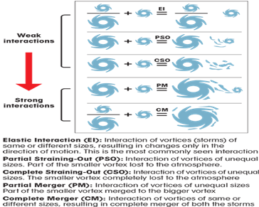
- There are five different ways in which Fujiwhara Effect can take place.
- Elastic interaction in which only the direction of motion of the storms changes and is the most common case but difficult to assess and need closer examination.
- Partial straining out in which a part of the smaller storm is lost to the atmosphere.
- Complete straining out in which the smaller storm is completely lost to the atmosphere. The straining out does not happen for storms of equal strengths.
- Partial merger in which the smaller storm merges into the bigger one
- Complete merger which takes places between two storms of similar strength.
- During a merger interaction between two tropical cyclones the wind circulations come together and form a sort of whirlpool of winds in the atmosphere.
- Fujiwhara effect was identified by Sakuhei Fujiwhara, a Japanese meteorologist in 1921.
- The first known instance of the effect was in 1964 in the western Pacific Ocean when typhoons Marie and Kathy merged.
Effect:
- It makes cyclones more unpredictable due to their rapid intensification, carrying of more rain and newer ways of moving over warming oceans.
- This is because each of the interactions between the two storm systems is unique and very difficult to capture with current climate models.
- This may result in large-scale devastation.
- In an increasingly warming world, a dance and merger between two large enough tropical cyclones over any of the global oceans could lead to the formation of a mega cyclone, causing devastation along coast-lines.
Examples:
- In April 2021, in Indian Ocean, cyclone Seroja interacted with cyclone Odette just off the coast of western Australia.
- Seroja became a unique storm because the northwestern coast of Australia is prone to cyclones while the southwestern part hit by the cyclone does not get much storm activity.
Source Down To Earth
Previous Year Question
Q.1) Consider the following statements: (2017)
- In tropical regions, Zika virus disease is transmitted by ‘the same mosquito that transmits dengue.
- Sexual transmission of Zika virus disease is possible
Which of the statements given above is/are correct?
- 1 only
- 2 only
- Both 1 and 2
- Neither 1 nor 2


